Enable Location

We need your location to show you interesting places around you

Discover nearby places

Find interesting locations and hidden gems around you

Precise directions

Get accurate directions and distances to places

Your location is never shared with other users. It's only used when you tap the location button.

Fort McClary

Log in to your account

Start exploring — it's free

Trusted by 61,324 travelers worldwide

Continue with Google
Continue with Apple
or

We will send you a code to connect

By continuing, you accept our Terms and Conditions and our Privacy Policy

Check your inbox

We've sent a pincode in your inbox. Please enter the code below.

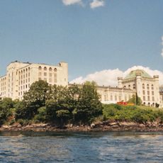
Fort McClary, Military fortification in Kittery, United States

Description

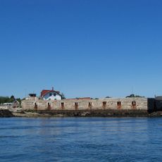
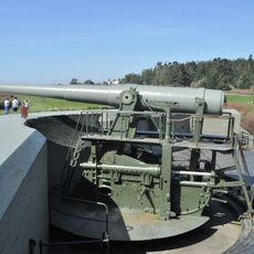
Fort McClary is a military fort located at Kittery where the Piscataqua River meets the coast between Maine and New Hampshire. The site contains a granite blockhouse, a powder magazine, and defensive walls that together formed a coastal defense position.

History

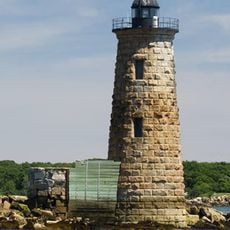
The site started as a defensive position in 1689 when William Pepperrell built initial fortifications, and the federal government created Fort McClary in 1808 as a formal installation. The hexagonal blockhouse built in 1844 represented how military design changed over the decades.

Culture

The blockhouse holds military objects and displays that show how people designed coastal defenses from the colonial period through World War I. You can see the actual strategies people used to protect the waterfront back then.

Practical

The fort opens to visitors from April through October, with guided tours available at the blockhouse that explain the military architecture. Plan to spend a few hours exploring the grounds, especially if you join a guided tour.

Did you know?

The blockhouse features a hexagonal shape rather than the typical square or rectangular fortress design, which allowed defenders to protect multiple angles at once. This distinctive form reflected practical solutions for guarding a river mouth.

Location
Inception
1808
GPS coordinates
43.08315,-70.70894
Latest update
December 8, 2025 19:55

AroundUs brings together thousands of curated places, local tips, and hidden gems, enriched daily by 60,000 contributors worldwide. Discover all places nearby (Kittery).

Around this place
Portsmouth Naval Prison
United States of America

Portsmouth Naval Prison

2 km
Fort William and Mary
United States of America

Fort William and Mary

1.3 km
Odiorne Point State Park
United States of America

Odiorne Point State Park

4.4 km
Memorial Bridge
United States of America

Memorial Bridge

3.6 km
Fort Stark
United States of America

Fort Stark

2.8 km
Bray House
United States of America

Bray House

503 m
Fort Foster
United States of America

Fort Foster

2.3 km
Portsmouth Harbor Light
United States of America

Portsmouth Harbor Light

1.3 km
Wentworth-Coolidge Mansion
United States of America

Wentworth-Coolidge Mansion

3.4 km
Whaleback Light
United States of America

Whaleback Light

2.9 km
Prescott Park
United States of America

Prescott Park

3.6 km
Wentworth-Gardner House
United States of America

Wentworth-Gardner House

3.5 km
Lady Pepperrell House
United States of America

Lady Pepperrell House

658 m
MacPheadris-Warner House
United States of America

MacPheadris-Warner House

3.8 km
First Congregational Church and Parsonage
United States of America

First Congregational Church and Parsonage

562 m
William Pepperrell House
United States of America

William Pepperrell House

433 m
John Paul Jones Memorial Park
United States of America

John Paul Jones Memorial Park

3.4 km
Rock Rest
United States of America

Rock Rest

3.7 km
Mark Wentworth House
United States of America

Mark Wentworth House

3.8 km
Gerrish Warehouse
United States of America

Gerrish Warehouse

796 m
Rice Public Library
United States of America

Rice Public Library

2.8 km
South Meetinghouse
United States of America

South Meetinghouse

3.7 km
William Dean Howells House
United States of America

William Dean Howells House

387 m
Kittery Community Center
United States of America

Kittery Community Center

2.7 km
Mark F. and Eliza J. Wentworth House
United States of America

Mark F. and Eliza J. Wentworth House

2.8 km
Samuel Badger Monument
United States of America

Samuel Badger Monument

3 km
Shapley Town House
United States of America

Shapley Town House

3.7 km
Robert and Louisa Traip House
United States of America

Robert and Louisa Traip House

2.8 km
Show the full map
« Fort McClary - Military fortification in Kittery, United States » is provided by Around Us (aroundus.com). Images and texts are derived from Wikimedia project under a Creative Commons license. You are allowed to copy, distribute, and modify copies of this page, under the conditions set by the license, as long as this note is clearly visible.

Discover hidden gems everywhere you go!

From secret cafés to breathtaking viewpoints, skip the crowded tourist spots and find places that match your style. Our app makes it easy with voice search, smart filtering, route optimization, and insider tips from travelers worldwide. Download now for the complete mobile experience.

Around Us App Screenshot

A unique approach to discovering new places

Le Figaro

All the places worth exploring

France Info

A tailor-made excursion in just a few clicks

20 Minutes

Around Us
Travel Guide & Maps
Download

Send to your phone

QR Code
1

Open the camera app on your mobile.

2

Point at the QR code with your camera. A notification will appear.

3

Tap the notification to open the link.