Enable Location

We need your location to show you interesting places around you

Discover nearby places

Find interesting locations and hidden gems around you

Precise directions

Get accurate directions and distances to places

Your location is never shared with other users. It's only used when you tap the location button.

Fells Connector Parkways

Log in to your account

Start exploring — it's free

Trusted by 61,867 travelers worldwide

Continue with Google
Continue with Apple
or

We will send you a code to connect

By continuing, you accept our Terms and Conditions and our Privacy Policy

Check your inbox

We've sent a pincode in your inbox. Please enter the code below.

Fells Connector Parkways, Connecting parkways between Mystic River and Middlesex Fells Reservation in Malden and Medford, Massachusetts.

Description

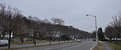
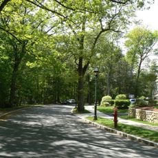
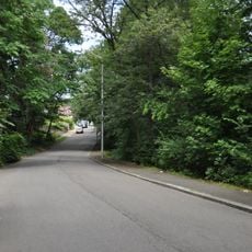
The Fells Connector Parkways system links the Mystic River to the Middlesex Fells Reservation through three main routes: the Fellsway, Fellsway West, and Fellsway East. This network passes through Malden and Medford with wide roads bordered by vegetated strips that soften the driving experience.

History

The Metropolitan Parks Commission began building these parkways in 1894 to create direct connections between Boston and the Middlesex Fells Reservation. The project was part of a broader movement in New England to make natural areas accessible through planned transportation corridors.

Culture

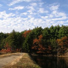
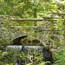
These roads show an early vision of cities where traffic and nature coexist rather than compete. They demonstrate how planners believed transportation corridors could preserve green spaces instead of paving over them.

Practical

These routes accommodate multiple types of traffic with clear lanes for cars and space for pedestrians along the edges. Visitors find it easiest to explore them by car, with regular access points connecting to the parks and recreation areas they serve.

Did you know?

The system was designed with wide rights-of-way specifically to preserve natural elements even as traffic moved through them. These green corridors were revolutionary for their era and show early thinking about protecting landscapes during urban expansion.

Location
Location
Inception
1895
GPS coordinates
42.44444,-71.07917
Latest update
December 12, 2025 17:48

AroundUs brings together thousands of curated places, local tips, and hidden gems, enriched daily by 60,000 contributors worldwide. Discover all places nearby (Malden).

Around this place
Middlesex Fells Reservation
United States of America

Middlesex Fells Reservation

3 km
Stone Zoo
United States of America

Stone Zoo

2.4 km
Waitt's Mountain
United States of America

Waitt's Mountain

1.6 km
Congregation Beth Israel
United States of America

Congregation Beth Israel

1.8 km
Converse Memorial Library
United States of America

Converse Memorial Library

2.2 km
Bell Rock Memorial Park
United States of America

Bell Rock Memorial Park

2.8 km
Bell Rock Cemetery
United States of America

Bell Rock Cemetery

3.1 km
John Bottume House
United States of America

John Bottume House

1.5 km
Middlesex Fells Reservation Parkways
United States of America

Middlesex Fells Reservation Parkways

1.9 km
Spot Pond Archeological District
United States of America

Spot Pond Archeological District

1.4 km
Jonathan Green House
United States of America

Jonathan Green House

2.5 km
Fellsmere Park Parkways
United States of America

Fellsmere Park Parkways

1.9 km
Beebe Estate
United States of America

Beebe Estate

1.4 km
Phineas Upham House
United States of America

Phineas Upham House

2.2 km
House at 118 Greenwood Street
United States of America

House at 118 Greenwood Street

3.4 km
Middlesex Fells Reservoirs Historic District
United States of America

Middlesex Fells Reservoirs Historic District

1.8 km
Henry Bradlee Jr. House
United States of America

Henry Bradlee Jr. House

3.7 km
House at 54 Spring Street
United States of America

House at 54 Spring Street

3.5 km
Old Ship Street Historic District
United States of America

Old Ship Street Historic District

3.6 km
St. Paul's Parish Church
United States of America

St. Paul's Parish Church

1.4 km
Central Square Historic District
United States of America

Central Square Historic District

3.4 km
David Kenney House
United States of America

David Kenney House

3.6 km
Odd Fellows Building
United States of America

Odd Fellows Building

2 km
Wilbur Fiske Haven House
United States of America

Wilbur Fiske Haven House

1.9 km
Elisha Wright Homestead
United States of America

Elisha Wright Homestead

3.4 km
Waitt Brick Block
United States of America

Waitt Brick Block

2.2 km
Metropolitan District Commission Pumping House
United States of America

Metropolitan District Commission Pumping House

1.6 km
Larrabee's Brick Block
United States of America

Larrabee's Brick Block

1.7 km
Show the full map
« Fells Connector Parkways - Connecting parkways between Mystic River and Middlesex Fells Reservation in Malden and Medford, Massachusetts » is provided by Around Us (aroundus.com). Images and texts are derived from Wikimedia project under a Creative Commons license. You are allowed to copy, distribute, and modify copies of this page, under the conditions set by the license, as long as this note is clearly visible.

Discover hidden gems everywhere you go!

From secret cafés to breathtaking viewpoints, skip the crowded tourist spots and find places that match your style. Our app makes it easy with voice search, smart filtering, route optimization, and insider tips from travelers worldwide. Download now for the complete mobile experience.

Around Us App Screenshot

A unique approach to discovering new places

Le Figaro

All the places worth exploring

France Info

A tailor-made excursion in just a few clicks

20 Minutes

Around Us
Travel Guide & Maps
Download

Send to your phone

QR Code
1

Open the camera app on your mobile.

2

Point at the QR code with your camera. A notification will appear.

3

Tap the notification to open the link.