Red River Gorge

Log in to your account

AroundUs is a community-driven map of interesting places, built by curious explorers like you. It grows with every review, story, and photo you share.
Connect to save your favorite spots, contribute locations, and create personalized routes.
By continuing, you accept our Terms and Conditions and our Privacy Policy
Add to collection
Map
Suggest a change
Share

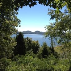
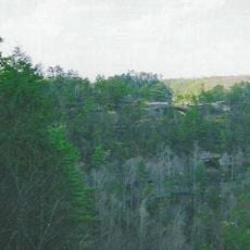
Red River Gorge, Natural canyon system in Slade, Kentucky, United States

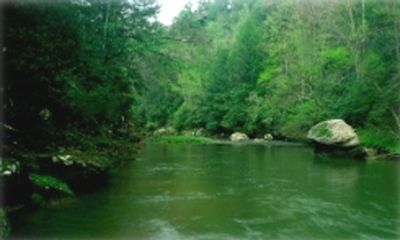
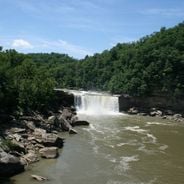
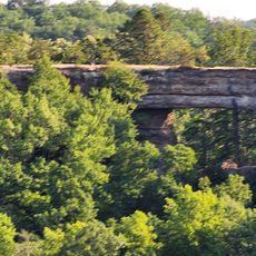
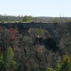
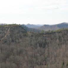
Red River Gorge is a natural canyon system with sandstone cliffs and arches within the Daniel Boone National Forest in Kentucky. The gorge cuts through forested hills and displays rock shelters, overhangs, and small streams that have carved through the soft stone over thousands of years.

Early inhabitants lived in the area about 11,000 years ago and left tools and traces in the rock shelters. In the early 20th century, a railway tunnel was built for logging transport and now serves as a main access route.

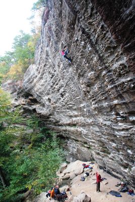
The name comes from the reddish tint of the sandstone walls, which glow especially at sunset. Rock climbers from around the world visit the more than 1,500 established routes that rise along the vertical faces.

Backcountry camping requires a permit that must be requested from the forest service in advance. More than 60 miles (95 kilometers) of marked trails run through the terrain and offer different difficulty levels for hikers and climbers.

A rare white-haired goldenrod grows in a limited section of the gorge and is found nowhere else in this form. The rock arches formed through erosion and freeze-thaw cycles, with some openings becoming visible only in recent decades.

Location: Kentucky

GPS coordinates: 37.83400,-83.60790

Latest update: December 12, 2025 18:04

Photos
Natural areas and historical sites in Kentucky

Kentucky combines natural areas and historical places in ways that tell the story of the state. Cave systems run beneath the earth, including Mammoth Cave, one of the world's largest. Rivers cut through gorges and valleys, creating waterfalls like Cumberland Falls and rock formations that draw...

Around this place
Cave Run Lake
United States of America

Cave Run Lake

29.4 km
Pilot Knob State Nature Preserve
United States of America

Pilot Knob State Nature Preserve

30.1 km
Furnace Mountain
United States of America

Furnace Mountain

21.8 km
Kentucky Reptile Zoo
United States of America

Kentucky Reptile Zoo

9.6 km
Clifty Wilderness
United States of America

Clifty Wilderness

3.9 km
Confederate Monument of Mt. Sterling
United States of America

Confederate Monument of Mt. Sterling

37.7 km
Natural Bridge
United States of America

Natural Bridge

9.6 km
Jackson Post Office
United States of America

Jackson Post Office

36.8 km
Ravenna Motor Vehicle Service Building
United States of America

Ravenna Motor Vehicle Service Building

34.6 km
Confederate Monument in Owingsville
United States of America

Confederate Monument in Owingsville

36.8 km
St. Thomas Episcopal Church
United States of America

St. Thomas Episcopal Church

30.2 km
Breathitt County Jail
United States of America

Breathitt County Jail

37 km
M.E. Church, South
United States of America

M.E. Church, South

37 km
St. Therese Catholic Church
United States of America

St. Therese Catholic Church

30.7 km
William L. Hurst Law Office
United States of America

William L. Hurst Law Office

12.3 km
Raccoon John Smith House
United States of America

Raccoon John Smith House

37.3 km
Thomas Deye Owings House
United States of America

Thomas Deye Owings House

37.2 km
Irvine Historic Business District
United States of America

Irvine Historic Business District

35.6 km
Irvine Grade School
United States of America

Irvine Grade School

35.1 km
Judge John E. Cooper House
United States of America

Judge John E. Cooper House

32.2 km
J.J. Nesbitt House
United States of America

J.J. Nesbitt House

37.3 km
Beattyville Grade School
United States of America

Beattyville Grade School

30.3 km
Clay City National Bank Building
United States of America

Clay City National Bank Building

27.7 km
Owingsville Commercial District and Courthouse Square
United States of America

Owingsville Commercial District and Courthouse Square

37.2 km
Jackson Commercial District
United States of America

Jackson Commercial District

36.9 km
Morgan County Courthouse
United States of America

Morgan County Courthouse

32.4 km
Natural Bridge State Resort Park
United States of America

Natural Bridge State Resort Park

9.8 km
Double Arch
United States of America

Double Arch

6.7 km
Show the full map
Reviews

Visited this place? Tap the stars to rate it and share your experience / photos with the community! Try now! You can cancel it anytime.

« Red River Gorge - Natural canyon system in Slade, Kentucky, United States » is provided by Around Us (aroundus.com). Images and texts are derived from Wikimedia project under a Creative Commons license. You are allowed to copy, distribute, and modify copies of this page, under the conditions set by the license, as long as this note is clearly visible.

Discover hidden gems everywhere you go!

From secret cafés to breathtaking viewpoints, skip the crowded tourist spots and find places that match your style. Our app makes it easy with voice search, smart filtering, route optimization, and insider tips from travelers worldwide. Download now for the complete mobile experience.

Around Us App Screenshot

A unique approach to discovering new places

Le Figaro

All the places worth exploring

France Info

A tailor-made excursion in just a few clicks

20 Minutes