Natural Bridge State Resort Park

Log in to your account

AroundUs is a community-driven map of interesting places, built by curious explorers like you. It grows with every review, story, and photo you share.
Connect to save your favorite spots, contribute locations, and create personalized routes.
By continuing, you accept our Terms and Conditions and our Privacy Policy

Natural Bridge State Resort Park

Add to collection
Map
Suggest a change
Share

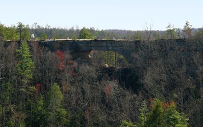
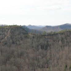
Natural Bridge State Resort Park, State park with sandstone arch in Powell County, Kentucky, US

Natural Bridge rises 65 feet high and extends 78 feet across, forming a natural sandstone arch through millions of years of weather erosion.

The park originated as a tourist destination in 1895 when the Lexington and Eastern Railroad developed the land before its transfer to Kentucky State Parks in 1926.

The 2,300-acre parkland includes multiple geological formations named by early settlers, such as Lovers Leap and Balanced Rock, which define local identity.

Visitors can reach the natural bridge through a half-mile Original Trail or take the aerial skylift system that transports guests directly to the formation.

The park contains over 20 miles of trails that connect to the 307-mile Sheltowee Trace National Recreation Trail through the Daniel Boone National Forest.

Location: Powell County

Location: Wolfe County

Inception: 1926

Website: https://parks.ky.gov/slade/parks/resort/natural-bridge-state-resort-park

Website: https://parks.ky.gov/slade/parks/resort/natural-bridge-state-resort-park

GPS coordinates: 37.77750,-83.69360

Latest update: March 3, 2025 02:43

Natural areas and historical sites in Kentucky

Kentucky combines natural areas and historical places. The state includes cave systems, Civil War battlefields, colonial structures, and rock formations. Mammoth Cave, the Civil War sites in Perryville and Mill Springs display the state's natural and cultural heritage.

Around this place
Show the full map
Red River Gorge
United States of America

Red River Gorge

9.8 km
Cave Run Lake
United States of America

Cave Run Lake

40.8 km
Pilot Knob State Nature Preserve
United States of America

Pilot Knob State Nature Preserve

26 km
Furnace Mountain
United States of America

Furnace Mountain

13.1 km
Clifty Wilderness
United States of America

Clifty Wilderness

12.8 km
Confederate Monument of Mt. Sterling
United States of America

Confederate Monument of Mt. Sterling

37.4 km
KEAS Tabernacle Christian Methodist Episcopal Church
United States of America

KEAS Tabernacle Christian Methodist Episcopal Church

37.7 km
Jackson Post Office
United States of America

Jackson Post Office

36.8 km
Enoch Smith House
United States of America

Enoch Smith House

38.6 km
Ravenna Motor Vehicle Service Building
United States of America

Ravenna Motor Vehicle Service Building

25 km
Confederate Monument in Owingsville
United States of America

Confederate Monument in Owingsville

41 km
Methodist Episcopal Church South
United States of America

Methodist Episcopal Church South

38.1 km
Church of the Ascension
United States of America

Church of the Ascension

38.1 km
St. Thomas Episcopal Church
United States of America

St. Thomas Episcopal Church

22.6 km
Breathitt County Jail
United States of America

Breathitt County Jail

37 km
M.E. Church, South
United States of America

M.E. Church, South

37 km
St. Therese Catholic Church
United States of America

St. Therese Catholic Church

21.7 km
William L. Hurst Law Office
United States of America

William L. Hurst Law Office

13.7 km
Corinth Christian Methodist Episcopal Church
United States of America

Corinth Christian Methodist Episcopal Church

40.4 km
Raccoon John Smith House
United States of America

Raccoon John Smith House

41.3 km
Thomas Deye Owings House
United States of America

Thomas Deye Owings House

41.3 km
Irvine Historic Business District
United States of America

Irvine Historic Business District

26.2 km
Irvine Grade School
United States of America

Irvine Grade School

25.7 km
J.J. Nesbitt House
United States of America

J.J. Nesbitt House

41.3 km
Beattyville Grade School
United States of America

Beattyville Grade School

22.8 km
Clay City National Bank Building
United States of America

Clay City National Bank Building

22 km
Jackson Commercial District
United States of America

Jackson Commercial District

36.9 km
Double Arch
United States of America

Double Arch

6.7 km
Show the full map

Reviews

Visited this place? Tap the stars to rate it and share your experience / photos with the community! Try now! You can cancel it anytime.

« Natural Bridge State Resort Park - State park with sandstone arch in Powell County, Kentucky, US » is provided by Around Us (aroundus.com). Images and texts are derived from Wikimedia project under a Creative Commons license. You are allowed to copy, distribute, and modify copies of this page, under the conditions set by the license, as long as this note is clearly visible.

Discover hidden gems everywhere you go!

From secret cafés to breathtaking viewpoints, skip the crowded tourist spots and find places that match your style. Our app makes it easy with voice search, smart filtering, route optimization, and insider tips from travelers worldwide. Download now for the complete mobile experience.

Around Us App Screenshot

A unique approach to discovering new places

Le Figaro

All the places worth exploring

France Info

A tailor-made excursion in just a few clicks

20 Minutes