Enable Location

We need your location to show you interesting places around you

Discover nearby places

Find interesting locations and hidden gems around you

Precise directions

Get accurate directions and distances to places

Your location is never shared with other users. It's only used when you tap the location button.

Wolfe County

Log in to your account

Start exploring — it's free

Trusted by 62,827 travelers worldwide

Continue with Google
Continue with Apple
or

We will send you a code to connect

By continuing, you accept our Terms and Conditions and our Privacy Policy

Check your inbox

We've sent a pincode in your inbox. Please enter the code below.

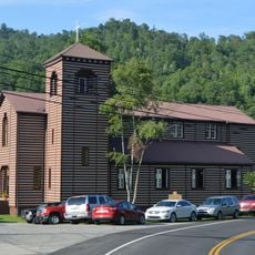
Wolfe County, County in Kentucky, United States.

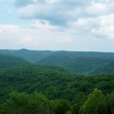
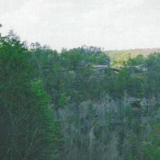
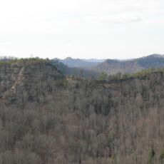
Wolfe County is an administrative division in Kentucky located at the intersection of four neighboring counties, spanning 223 square miles of dense woodlands and rolling hills. The Daniel Boone National Forest encompasses a substantial portion of the county and shapes its forested landscape.

The county was established on March 5, 1860, and named after Nathaniel Wolfe, a Unionist attorney and University of Virginia graduate who played a role in the region's formation. Its founding occurred during a period of mounting tensions in the nation.

The Swift Silver Mine Festival brings community members together each Labor Day weekend with a traditional parade and local vendors in downtown Campton. The event reflects the region's connection to its mining heritage and local identity.

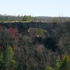
Visitors find hundreds of miles of marked trails in the Daniel Boone National Forest for outdoor activities at various difficulty levels. The best time for hiking is during autumn and spring when weather is mild and trails remain readily accessible.

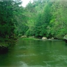
The Red River flowing through the county is Kentucky's only waterway holding official Wild and Scenic River designation from the federal government. This protected status shields the river from dams and alterations, making it a rare natural treasure in the region.

The community of curious travelers

AroundUs brings together thousands of curated places, local tips, and hidden gems, enriched daily by 60,000 contributors worldwide.

Start exploring
Location
Inception
March 5, 1860
Capital city
Campton
Shares border with
Morgan County, Magoffin County, Breathitt County, Lee County, Menifee County, Powell County
GPS coordinates
37.74000,-83.49000
Latest update
December 7, 2025 19:32
Around this place
Red River Gorge
United States of America

Red River Gorge

14.7 km
United States of America

Eastern Kentucky Coal Field region

35.8 km
Cave Run Lake
United States of America

Cave Run Lake

38 km
United States of America

Pilot Knob State Nature Preserve

43.6 km
Furnace Mountain
United States of America

Furnace Mountain

31.2 km
Kentucky Reptile Zoo
United States of America

Kentucky Reptile Zoo

19.7 km
Robinson Forest
United States of America

Robinson Forest

42.6 km
Magoffin County Pioneer Village and Museum
United States of America

Magoffin County Pioneer Village and Museum

37.2 km
Clifty Wilderness
United States of America

Clifty Wilderness

11.9 km
Salyersville National Bank
United States of America

Salyersville National Bank

37.1 km
Buckhorn Presbyterian Church and the Greer Gymnasium
United States of America

Buckhorn Presbyterian Church and the Greer Gymnasium

43.6 km
Jackson Post Office
United States of America

Jackson Post Office

22.7 km
Ravenna Motor Vehicle Service Building
United States of America

Ravenna Motor Vehicle Service Building

41.2 km
St. Thomas Episcopal Church
United States of America

St. Thomas Episcopal Church

26.7 km
Breathitt County Jail
United States of America

Breathitt County Jail

22.8 km
M.E. Church, South
United States of America

M.E. Church, South

22.8 km
St. Therese Catholic Church
United States of America

St. Therese Catholic Church

30.3 km
William L. Hurst Law Office
United States of America

William L. Hurst Law Office

5.1 km
Irvine Historic Business District
United States of America

Irvine Historic Business District

42.9 km
Judge John E. Cooper House
United States of America

Judge John E. Cooper House

28.8 km
Irvine Grade School
United States of America

Irvine Grade School

42.4 km
Beattyville Grade School
United States of America

Beattyville Grade School

26.5 km
Clay City National Bank Building
United States of America

Clay City National Bank Building

40.2 km
Jackson Commercial District
United States of America

Jackson Commercial District

22.8 km
Morgan County Courthouse
United States of America

Morgan County Courthouse

28.8 km
Natural Bridge State Resort Park
United States of America

Natural Bridge State Resort Park

18.4 km
Double Arch
United States of America

Double Arch

20.2 km
Stacey Hotel
United States of America

Stacey Hotel

22.9 km
Show the full map
Administrative divisions
« Wolfe County - County in Kentucky, United States » is provided by Around Us (aroundus.com). Images and texts are derived from Wikimedia project under a Creative Commons license. You are allowed to copy, distribute, and modify copies of this page, under the conditions set by the license, as long as this note is clearly visible.

Discover hidden gems everywhere you go!

From secret cafés to breathtaking viewpoints, skip the crowded tourist spots and find places that match your style. Our app makes it easy with voice search, smart filtering, route optimization, and insider tips from travelers worldwide. Download now for the complete mobile experience.

Around Us App Screenshot

A unique approach to discovering new places

Le Figaro

All the places worth exploring

France Info

A tailor-made excursion in just a few clicks

20 Minutes

Around Us
Travel Guide & Maps
Download

Send to your phone

QR Code
1

Open the camera app on your mobile.

2

Point at the QR code with your camera. A notification will appear.

3

Tap the notification to open the link.