Fort Randall, Military fort near Missouri River, South Dakota.
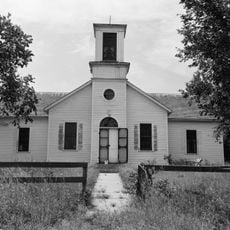
Fort Randall sits on the western bank of the Missouri River with preserved stone walls and building foundations from its original military structures built in 1856. The site features a parade ground with interpretive markers that explain the fort's layout and how soldiers used the various buildings.
The fort was established in 1856 and operated for decades as a military outpost on the frontier between settlers and Lakota territory. It later became a location where notable tribal leaders were held under guard, marking important moments in relations between the US government and Native nations.
This location served as a meeting point between military forces and local Lakota communities over many decades. The ruins and grounds today reflect how soldiers and Native peoples coexisted in this remote outpost and shaped one another's history.
The grounds are easy to walk through and offer clear views of all remaining structures throughout the site. Wear comfortable shoes and plan time to read the interpretive signs to understand what each building area was used for and where things were located.
This location served as a meeting point between high-ranking tribal leaders and the American military establishment during critical historical moments. These encounters and relationships between officials and indigenous leaders influenced larger negotiations over the future of Plains peoples.
Location: South Dakota
Inception: 1856
GPS coordinates: 43.02444,-98.62417
Latest update: December 10, 2025 20:00
Niobrara Formation
56.8 km
Niobrara State Park
56.1 km
Chief Standing Bear Memorial Bridge
59 kmLake Andes National Wildlife Refuge
22.8 km
Snake Creek Recreation Area
57.2 kmWhite Horse Ranch
39.2 km
Niobrara River Bridge
55 km
Congregational Church and Manse
66.7 km
Herrick Elevator
46.8 km
Church of Our Most Merciful Saviour
67.3 km
Delmont Public School
46 km
Rad Sladkovsky
47.3 km
ZCBJ Hall
61.8 km
Church of Christ in LaRoche Township
60.7 km
Rouse Ranch
36.8 km
Brantly Sturdevant House
62.3 km
William P. Smith House
65.1 km
Armour Historic District
39.7 km
Holt County Courthouse
62.9 km
Charles Mix County Courthouse
16.2 km
Old Nebraska State Bank Building
63.2 km
Bon Homme County Courthouse
61.8 km
Ponca Tribal Self-Help Community Building Historic District
55.8 km
Douglas County Courthouse
39.5 km
Delmont State Bank
46.4 km
Wagner House
38 km
Gross State Aid Bridge
62.8 km
Lake Francis Case
6.4 kmVisited this place? Tap the stars to rate it and share your experience / photos with the community! Try now! You can cancel it anytime.
Discover hidden gems everywhere you go!
From secret cafés to breathtaking viewpoints, skip the crowded tourist spots and find places that match your style. Our app makes it easy with voice search, smart filtering, route optimization, and insider tips from travelers worldwide. Download now for the complete mobile experience.
A unique approach to discovering new places❞
— Le Figaro
All the places worth exploring❞
— France Info
A tailor-made excursion in just a few clicks❞
— 20 Minutes