Enable Location

We need your location to show you interesting places around you

Discover nearby places

Find interesting locations and hidden gems around you

Precise directions

Get accurate directions and distances to places

Your location is never shared with other users. It's only used when you tap the location button.

Log in to your account

Start exploring — it's free

Trusted by 62,983 travelers worldwide

Continue with Google
Continue with Apple
or

We will send you a code to connect

By continuing, you accept our Terms and Conditions and our Privacy Policy

Check your inbox

We've sent a pincode in your inbox. Please enter the code below.

Peru Peak Wilderness
Discussion Reviews Photo
1.2k Popularity

Peru Peak Wilderness, Federal wilderness area in Green Mountain National Forest, Vermont, United States

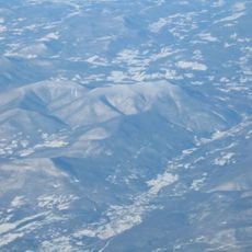
Peru Peak Wilderness is a protected forest area within Vermont's Green Mountains covering approximately 7,800 acres of mountain terrain. The landscape combines thick woodlands with rocky outcrops and several ridges with peaks exceeding 2,900 feet in elevation.

The Vermont Wilderness Act of 1984 created this protected area to preserve natural conditions in the region. A later expansion through the New England Wilderness Act of 2006 enlarged the designated wilderness boundaries.

The Abenaki people, part of the Algonquin-speaking nations, inhabited this region for countless generations before European contact transformed the landscape. Their long connection to these mountains remains part of the area's identity.

The Long Trail and Appalachian Trail cross through the wilderness with marked routes to several peaks from the Mad Tom Notch trailhead. Hikers should prepare for both maintained paths and rougher terrain in certain sections.

The northern section remains without marked trails, including Pete Parent Peak at approximately 2,961 feet, one of the few summits without established routes. This area offers experienced hikers an opportunity to navigate unmarked terrain.

The community of curious travelers

AroundUs brings together thousands of curated places, local tips, and hidden gems, enriched daily by 60,000 contributors worldwide.

Start exploring
Location
GPS coordinates
43.30417,-72.93194
Latest update
December 14, 2025 18:42
Around this place
Equinox Mountain
United States of America

Equinox Mountain

21.6 km
Bill Wilson House
United States of America

Bill Wilson House

9.5 km
Weston Priory
United States of America

Weston Priory

11.9 km
United States of America

Mount Aeolus

11.2 km
The American Museum of Fly Fishing
United States of America

The American Museum of Fly Fishing

18.7 km
Dorset Mountain
United States of America

Dorset Mountain

7.8 km
Crowley Cheese Factory
United States of America

Crowley Cheese Factory

17.8 km
Manley-Lefevre House
United States of America

Manley-Lefevre House

15.1 km
Equinox House Historic District
United States of America

Equinox House Historic District

19.6 km
United States of America

Terrible Mountain

15.3 km
Laurel Glen Mausoleum-Laurel Hall
United States of America

Laurel Glen Mausoleum-Laurel Hall

20.5 km
Farrar-Mansur House
United States of America

Farrar-Mansur House

11.2 km
Wallingford Main Street Historic District
United States of America

Wallingford Main Street Historic District

19 km
Dorset Village Historic District
United States of America

Dorset Village Historic District

14.6 km
John Wilder House
United States of America

John Wilder House

11.2 km
Anthony Scoville House
United States of America

Anthony Scoville House

20.5 km
South Londonderry Village Historic District
United States of America

South Londonderry Village Historic District

16.2 km
Congregational Church of Ludlow
United States of America

Congregational Church of Ludlow

21.6 km
Tinmouth Historic District
United States of America

Tinmouth Historic District

18.8 km
Pawlet Town Hall
United States of America

Pawlet Town Hall

20.5 km
Weston Village Historic District
United States of America

Weston Village Historic District

11.2 km
Londonderry Town House
United States of America

Londonderry Town House

15.4 km
Nathan Allen House
United States of America

Nathan Allen House

21.5 km
Danby Village Historic District
United States of America

Danby Village Historic District

7.1 km
Amos Lawrence House
United States of America

Amos Lawrence House

18.3 km
Simons' Inn
United States of America

Simons' Inn

18.2 km
Kent Neighborhood Historic District
United States of America

Kent Neighborhood Historic District

15.3 km
Gen. Robinson Hall House
United States of America

Gen. Robinson Hall House

14.7 km
Show the full map
Reviews
Share your experience

No review yet

Discussions
Start a discussion...

No discussion yet

« Peru Peak Wilderness - Federal wilderness area in Green Mountain National Forest, Vermont, United States » is provided by Around Us (aroundus.com). Images and texts are derived from Wikimedia project under a Creative Commons license. You are allowed to copy, distribute, and modify copies of this page, under the conditions set by the license, as long as this note is clearly visible.

Discover hidden gems everywhere you go!

From secret cafés to breathtaking viewpoints, skip the crowded tourist spots and find places that match your style. Our app makes it easy with voice search, smart filtering, route optimization, and insider tips from travelers worldwide. Download now for the complete mobile experience.

Around Us App Screenshot

A unique approach to discovering new places

Le Figaro

All the places worth exploring

France Info

A tailor-made excursion in just a few clicks

20 Minutes

Around Us
Travel Guide & Maps
Download

Send to your phone

QR Code
1

Open the camera app on your mobile.

2

Point at the QR code with your camera. A notification will appear.

3

Tap the notification to open the link.