Enable Location

We need your location to show you interesting places around you

Discover nearby places

Find interesting locations and hidden gems around you

Precise directions

Get accurate directions and distances to places

Your location is never shared with other users. It's only used when you tap the location button.

Otis Air National Guard Base

Log in to your account

Start exploring — it's free

Trusted by 64,550 travelers worldwide

Continue with Google
Continue with Apple
or

We will send you a code to connect

By continuing, you accept our Terms and Conditions and our Privacy Policy

Check your inbox

We've sent a pincode in your inbox. Please enter the code below.

Otis Air National Guard Base
Discussion Reviews 1 Photos
38.7k Popularity

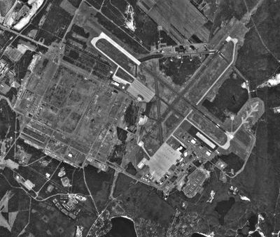
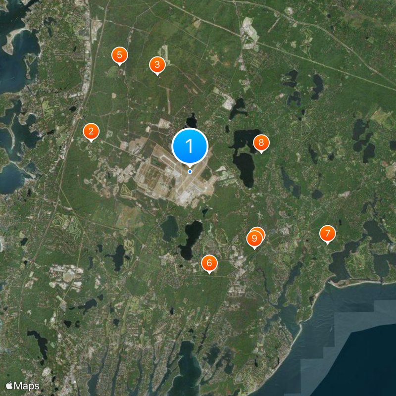
Otis Air National Guard Base, Military airport in Falmouth, Massachusetts.

Otis Air National Guard Base is a military airport in Falmouth with multiple runways, including a 9,501-foot primary runway and an 8,000-foot secondary runway serving various aircraft types. The facility operates continuously and houses personnel and equipment for regional defense operations.

The base was established in March 1941 as a military training facility. It evolved into a significant air station for coastal defense operations across the northeastern United States.

A retired F-15 Eagle jet sits at the base entrance, marking the history of the 102nd Intelligence Wing. This aircraft serves as a reminder of the aerial operations that shaped the region's defense role.

Access is restricted since this is an active military installation, with most areas off-limits to the public. Those interested in learning more should check ahead for scheduled tours or public events.

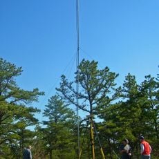
The base operates advanced radar systems that monitor the eastern coast of North America for distant threats. This surveillance role remains a crucial but often overlooked part of regional defense infrastructure.

The community of curious travelers

AroundUs brings together thousands of curated places, local tips, and hidden gems, enriched daily by 60,000 contributors worldwide.

Start exploring
Location
GPS coordinates
41.65861,-70.52139
Latest update
December 17, 2025 09:29
Around this place
Massachusetts National Cemetery
United States of America

Massachusetts National Cemetery

5.4 km
Fort Banks
United States of America

Fort Banks

5.3 km
Old Indian Meeting House
United States of America

Old Indian Meeting House

5.2 km
Pine Hill
United States of America

Pine Hill

6.7 km
Mashpee National Wildlife Refuge
United States of America

Mashpee National Wildlife Refuge

5.4 km
Lowell Park
United States of America

Lowell Park

8.1 km
Lowell Holly Reservation
United States of America

Lowell Holly Reservation

3.9 km
Mashpee River Reservation
United States of America

Mashpee River Reservation

5.2 km
Waquoit Historic District
United States of America

Waquoit Historic District

8.1 km
Santuit Historic District
United States of America

Santuit Historic District

6.3 km
Mashpee Wampanoag Indian Museum
United States of America

Mashpee Wampanoag Indian Museum

3.1 km
Goodspeed House
United States of America

Goodspeed House

8.5 km
North Falmouth Village Historic District
United States of America

North Falmouth Village Historic District

8.1 km
William Marston House
United States of America

William Marston House

8.9 km
Forestdale School
United States of America

Forestdale School

4.1 km
Gideon Hawley House
United States of America

Gideon Hawley House

6.1 km
Avant House
United States of America

Avant House

3.1 km
Town Boundary Marker
United States of America

Town Boundary Marker

7.7 km
Sampson's Folly
United States of America

Sampson's Folly

6.9 km
Elnathan Nye House
United States of America

Elnathan Nye House

8.6 km
Cotuit Historic District
United States of America

Cotuit Historic District

8.5 km
Cataumet Schoolhouse
United States of America

Cataumet Schoolhouse

7.3 km
Ebenezer Crocker Jr. House
United States of America

Ebenezer Crocker Jr. House

8.4 km
Nelson Rhodehouse House
United States of America

Nelson Rhodehouse House

6.6 km
Harlow Homestead
United States of America

Harlow Homestead

7.3 km
Charles L. Baxter House
United States of America

Charles L. Baxter House

6.4 km
Liberty Hall
United States of America

Liberty Hall

9 km
Camp Burgess Waterfront
United States of America

Camp Burgess Waterfront

7.1 km
Show the full map
Reviews
Share your experience

No review yet

Discussions
Start a discussion...

No discussion yet

« Otis Air National Guard Base - Military airport in Falmouth, Massachusetts » is provided by Around Us (aroundus.com). Images and texts are derived from Wikimedia project under a Creative Commons license. You are allowed to copy, distribute, and modify copies of this page, under the conditions set by the license, as long as this note is clearly visible.

Discover hidden gems everywhere you go!

From secret cafés to breathtaking viewpoints, skip the crowded tourist spots and find places that match your style. Our app makes it easy with voice search, smart filtering, route optimization, and insider tips from travelers worldwide. Download now for the complete mobile experience.

Around Us App Screenshot

A unique approach to discovering new places

Le Figaro

All the places worth exploring

France Info

A tailor-made excursion in just a few clicks

20 Minutes

Around Us
Travel Guide & Maps
Download

Send to your phone

QR Code
1

Open the camera app on your mobile.

2

Point at the QR code with your camera. A notification will appear.

3

Tap the notification to open the link.