Enable Location

We need your location to show you interesting places around you

Discover nearby places

Find interesting locations and hidden gems around you

Precise directions

Get accurate directions and distances to places

Your location is never shared with other users. It's only used when you tap the location button.

Sideling Hill

Log in to your account

Start exploring — it's free

Trusted by 64,608 travelers worldwide

Continue with Google
Continue with Apple
or

We will send you a code to connect

By continuing, you accept our Terms and Conditions and our Privacy Policy

Check your inbox

We've sent a pincode in your inbox. Please enter the code below.

Sideling Hill
Discussion Reviews 1 Photos
23.6k Popularity

Sideling Hill, Mountain ridge in Ridge-and-Valley Appalachians, United States.

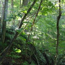
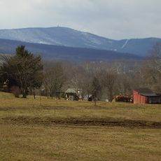
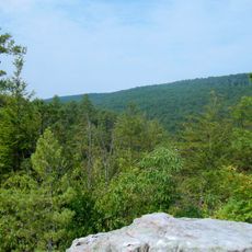
Sideling Hill is a mountain ridge in the Ridge-and-Valley province of the southern Appalachians, stretching across Maryland, West Virginia, and Pennsylvania. The ridge is covered with oak-hickory forest and has multiple trails and a wildlife management area.

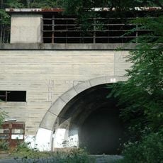
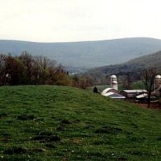
A railroad tunnel cut through Sideling Hill during the 1870s, representing an early transportation project in the region. This connection allowed remote coal-mining communities to reach larger markets.

The name refers to the steep slopes that define the ridge and overlook the valley below. Locals and visitors use the forests for hunting and wildlife watching, reflecting the area's role in regional outdoor recreation.

The area is accessible year-round and offers trails for different fitness levels. Spring and fall are the best times to visit, with mild temperatures and good trail conditions.

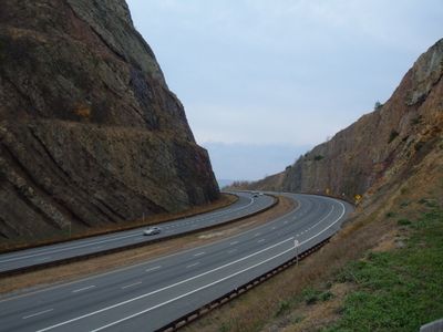
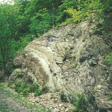
Where Interstate 68 cuts through the ridge, a massive rock wall towers about 810 feet (247 m) high, exposing millions of years of geological layering. This roadside exposure attracts geology students and earth science classes studying rock formations.

The community of curious travelers

AroundUs brings together thousands of curated places, local tips, and hidden gems, enriched daily by 60,000 contributors worldwide.

Start exploring
Location
Part of
Ridge-and-Valley Appalachians
GPS coordinates
39.71920,-78.28360
Latest update
December 20, 2025 13:56
Around this place
Samuel Taylor Suit Cottage
United States of America

Samuel Taylor Suit Cottage

11.2 km
Fort Frederick
United States of America

Fort Frederick

25.6 km
Berkeley Springs State Park
United States of America

Berkeley Springs State Park

11.4 km
United States of America

Mid State Trail

24 km
Green Ridge State Forest
United States of America

Green Ridge State Forest

14.9 km
Cacapon Resort State Park
United States of America

Cacapon Resort State Park

23.8 km
Buchanan State Forest
United States of America

Buchanan State Forest

25.9 km
Cross Mountain
United States of America

Cross Mountain

25 km
Martin Hill
United States of America

Martin Hill

26.2 km
Sleepy Creek Mountain
United States of America

Sleepy Creek Mountain

30 km
Roundtop Hill
United States of America

Roundtop Hill

6.2 km
United States of America

State Game Lands Number 49

15.2 km
Breakneck Road Historic District
United States of America

Breakneck Road Historic District

28.5 km
Jacksons Mill Covered Bridge
United States of America

Jacksons Mill Covered Bridge

28.1 km
Feltons Mill Covered Bridge
United States of America

Feltons Mill Covered Bridge

28.3 km
Morgan County Courthouse
United States of America

Morgan County Courthouse

11.1 km
Town of Bath Historic District
United States of America

Town of Bath Historic District

11.4 km
Yeakle's Mill Bridge
United States of America

Yeakle's Mill Bridge

21.2 km
Hewitt Covered Bridge
United States of America

Hewitt Covered Bridge

19.9 km
T. H. B. Dawson House
United States of America

T. H. B. Dawson House

11.6 km
Victor Cushwa Memorial Bridge
United States of America

Victor Cushwa Memorial Bridge

221 m
Clarence Hovermale House
United States of America

Clarence Hovermale House

11.2 km
Sloat-Horn-Rossell House
United States of America

Sloat-Horn-Rossell House

11.4 km
Cacapon State Park Nature Center
United States of America

Cacapon State Park Nature Center

24.4 km
Star Theatre
United States of America

Star Theatre

11.3 km
Judge John W. Wright Cottage
United States of America

Judge John W. Wright Cottage

11.6 km
John Herbert Quick House
United States of America

John Herbert Quick House

15.3 km
Hancock Bridge
United States of America

Hancock Bridge

8.8 km
Show the full map
Reviews
Share your experience

No review yet

Discussions
Start a discussion...

No discussion yet

« Sideling Hill - Mountain ridge in Ridge-and-Valley Appalachians, United States » is provided by Around Us (aroundus.com). Images and texts are derived from Wikimedia project under a Creative Commons license. You are allowed to copy, distribute, and modify copies of this page, under the conditions set by the license, as long as this note is clearly visible.

Discover hidden gems everywhere you go!

From secret cafés to breathtaking viewpoints, skip the crowded tourist spots and find places that match your style. Our app makes it easy with voice search, smart filtering, route optimization, and insider tips from travelers worldwide. Download now for the complete mobile experience.

Around Us App Screenshot

A unique approach to discovering new places

Le Figaro

All the places worth exploring

France Info

A tailor-made excursion in just a few clicks

20 Minutes

Around Us
Travel Guide & Maps
Download

Send to your phone

QR Code
1

Open the camera app on your mobile.

2

Point at the QR code with your camera. A notification will appear.

3

Tap the notification to open the link.