Enable Location

We need your location to show you interesting places around you

Discover nearby places

Find interesting locations and hidden gems around you

Precise directions

Get accurate directions and distances to places

Your location is never shared with other users. It's only used when you tap the location button.

145th Street Bridge

Log in to your account

Start exploring — it's free

Trusted by 61,342 travelers worldwide

Continue with Google
Continue with Apple
or

We will send you a code to connect

By continuing, you accept our Terms and Conditions and our Privacy Policy

Check your inbox

We've sent a pincode in your inbox. Please enter the code below.

145th Street Bridge

145th Street Bridge, Swing bridge across Harlem River between Manhattan and Bronx, United States

Description

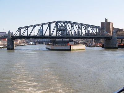
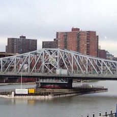
The 145th Street Bridge is a swing bridge that crosses the Harlem River between Manhattan and the Bronx, connecting two neighborhoods with four traffic lanes. The structure allows pedestrians to walk on both sides while vehicles and buses travel along the roadway.

History

Construction started in 1901 and was completed four years later in 1905, when traffic first crossed the swing bridge. In 2006, the rotating mechanism was fundamentally renewed and transported by water to its current location.

Culture

The bridge links two distinct neighborhoods and allows residents from different areas to meet and work together across the river. For many commuters, crossing here is a daily moment in the rhythm of the city.

Practical

The bridge features wide sidewalks on both sides, making walking safe and pleasant even with traffic moving around you. Public buses and private vehicles share the same lanes, so walking during quieter times offers a more comfortable experience.

Did you know?

The bridge can rotate to allow larger ships to pass through the Harlem River, a capability that sets it apart from other river crossings. This rotating feature is uncommon and makes the structure remarkable from a traffic engineering perspective.

Location
Official opening
1905
Longest Span
90 m
GPS coordinates
40.81946,-73.93305
Latest update
December 9, 2025 18:42

AroundUs brings together thousands of curated places, local tips, and hidden gems, enriched daily by 60,000 contributors worldwide. Discover all places nearby (Manhattan).

Around this place
Rucker Park
United States of America

Rucker Park

1.2 km
Lorelei Fountain
United States of America

Lorelei Fountain

1.2 km
Abyssinian Baptist Church
United States of America

Abyssinian Baptist Church

791 m
Schomburg Center for Research in Black Culture
United States of America

Schomburg Center for Research in Black Culture

879 m
St. Nicholas Historic District
United States of America

St. Nicholas Historic District

901 m
Macombs Dam Bridge
United States of America

Macombs Dam Bridge

959 m
Bronx County Courthouse
United States of America

Bronx County Courthouse

1.1 km
Madison Avenue Bridge
United States of America

Madison Avenue Bridge

590 m
Dunbar Apartments
United States of America

Dunbar Apartments

760 m
Jackie Robinson Park
United States of America

Jackie Robinson Park

1.1 km
369th Regiment Armory
United States of America

369th Regiment Armory

260 m
Harlem YMCA
United States of America

Harlem YMCA

987 m
Mother African Methodist Episcopal Zion Church
United States of America

Mother African Methodist Episcopal Zion Church

832 m
Universal Hip Hop Museum
United States of America

Universal Hip Hop Museum

347 m
United States Post Office–Bronx Central Annex
United States of America

United States Post Office–Bronx Central Annex

519 m
James Weldon Johnson Residence
United States of America

James Weldon Johnson Residence

963 m
Dark Tower
United States of America

Dark Tower

841 m
Matthew Henson Residence
United States of America

Matthew Henson Residence

821 m
Florence Mills House
United States of America

Florence Mills House

1 km
Bronx Children's Museum
United States of America

Bronx Children's Museum

561 m
Will Marion Cook House
United States of America

Will Marion Cook House

909 m
St. Mark the Evangelist's Church
United States of America

St. Mark the Evangelist's Church

620 m
Hostos Center for the Arts & Culture
United States of America

Hostos Center for the Arts & Culture

536 m
West 147th-149th Streets Historic District
United States of America

West 147th-149th Streets Historic District

730 m
Mount Calvary United Methodist Church
United States of America

Mount Calvary United Methodist Church

1.1 km
Sugar Hill Historic District
United States of America

Sugar Hill Historic District

1.2 km
James Bailey House
United States of America

James Bailey House

1.2 km
103 West 135th Street
United States of America

103 West 135th Street

881 m
Show the full map
« 145th Street Bridge - Swing bridge across Harlem River between Manhattan and Bronx, United States » is provided by Around Us (aroundus.com). Images and texts are derived from Wikimedia project under a Creative Commons license. You are allowed to copy, distribute, and modify copies of this page, under the conditions set by the license, as long as this note is clearly visible.

Discover hidden gems everywhere you go!

From secret cafés to breathtaking viewpoints, skip the crowded tourist spots and find places that match your style. Our app makes it easy with voice search, smart filtering, route optimization, and insider tips from travelers worldwide. Download now for the complete mobile experience.

Around Us App Screenshot

A unique approach to discovering new places

Le Figaro

All the places worth exploring

France Info

A tailor-made excursion in just a few clicks

20 Minutes

Around Us
Travel Guide & Maps
Download

Send to your phone

QR Code
1

Open the camera app on your mobile.

2

Point at the QR code with your camera. A notification will appear.

3

Tap the notification to open the link.