Enable Location

We need your location to show you interesting places around you

Discover nearby places

Find interesting locations and hidden gems around you

Precise directions

Get accurate directions and distances to places

Your location is never shared with other users. It's only used when you tap the location button.

75th Police Precinct Station House

Log in to your account

Start exploring — it's free

Trusted by 62,483 travelers worldwide

Continue with Google
Continue with Apple
or

We will send you a code to connect

By continuing, you accept our Terms and Conditions and our Privacy Policy

Check your inbox

We've sent a pincode in your inbox. Please enter the code below.

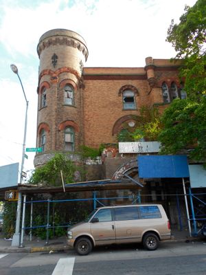
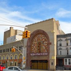
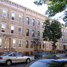
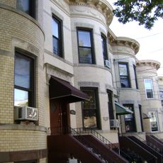
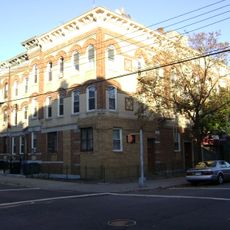
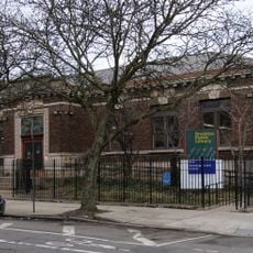
75th Police Precinct Station House, historic police station located in Brooklyn, New York

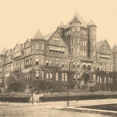
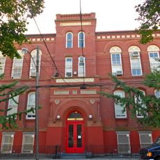
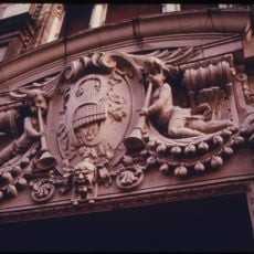
The 75th Police Precinct Station House is a three-story yellow brick building with Romanesque Revival architecture in Brooklyn. It features a distinctive corner tower, rounded arches, carved details, and an entrance portico with European design elements that remain visible today.

The building was designed by architect Emile M. Gruwe in 1886 and completed in 1891 when Brooklyn was expanding rapidly and needed more police stations. It served as a police station until 1973, was sold to People's First Baptist Church in 1976, and was added to the National Register of Historic Places in 2007.

The building earned the local nickname "The Castle" because its massive, fortress-like appearance reminded people of an actual castle. This name reflects how neighbors perceived the structure and what it meant to them as a community landmark.

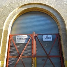
The building is viewable from the outside and remains a visible landmark in the neighborhood, though it is not currently open to the public. The best way to see it is to walk along Liberty Avenue where you can observe its most notable features from the street.

The building originally featured crenellations along its roofline that resembled an actual castle tower, but these striking features are no longer visible today. These lost elements show how much the building's appearance has changed over time.

The community of curious travelers

AroundUs brings together thousands of curated places, local tips, and hidden gems, enriched daily by 60,000 contributors worldwide.

Start exploring
Location
Inception
1886
Architectural style
Romanesque Revival architecture
Address
484 Liberty Avenue
GPS coordinates
40.67472,-73.89250
Latest update
February 7, 2026 11:40
Around this place
Fulton Street
United States of America

Fulton Street

3 km
Christian Cultural Center
United States of America

Christian Cultural Center

2.7 km
United States of America

Betsy Head Memorial Playground

2.2 km
Mount Carmel Cemetery
United States of America

Mount Carmel Cemetery

2.4 km
United States of America

Union Course

3.1 km
Zion Triangle
United States of America

Zion Triangle

2.3 km
Substation 401
United States of America

Substation 401

1 km
Brooklyn Hebrew Orphan Asylum
United States of America

Brooklyn Hebrew Orphan Asylum

2.5 km
Public School 108
United States of America

Public School 108

968 m
St. Matthias Roman Catholic Church Complex
United States of America

St. Matthias Roman Catholic Church Complex

3.2 km
Parkway Theatre
United States of America

Parkway Theatre

2.3 km
Central Ridgewood Historic District
United States of America

Central Ridgewood Historic District

3.2 km
Cypress Avenue East Historic District
United States of America

Cypress Avenue East Historic District

3.3 km
Cooper Avenue Row Historic District
United States of America

Cooper Avenue Row Historic District

2.6 km
Public School 65K
United States of America

Public School 65K

1.6 km
Immanuel Congregational Church
United States of America

Immanuel Congregational Church

2.9 km
Seneca Avenue East Historic District
United States of America

Seneca Avenue East Historic District

2.9 km
Summerfield Street Row Historic District
United States of America

Summerfield Street Row Historic District

2.9 km
Central Avenue Historic District
United States of America

Central Avenue Historic District

3.1 km
75th Avenue–61st Street Historic District
United States of America

75th Avenue–61st Street Historic District

2.7 km
68th Avenue–64th Place Historic District
United States of America

68th Avenue–64th Place Historic District

3.4 km
Seneca-Onderdonk-Woodward Historic District
United States of America

Seneca-Onderdonk-Woodward Historic District

3.3 km
Cornelia-Putnam Historic District
United States of America

Cornelia-Putnam Historic District

3 km
Forest-Norman Historic District
United States of America

Forest-Norman Historic District

2.8 km
Blessed Sacrament Church
United States of America

Blessed Sacrament Church

1.8 km
Loew's Pitkin Theatre
United States of America

Loew's Pitkin Theatre

2.2 km
RKO Bushwick Theatre
United States of America

RKO Bushwick Theatre

2.8 km
Saratoga Library
United States of America

Saratoga Library

2.2 km
Show the full map
« 75th Police Precinct Station House - historic police station located in Brooklyn, New York » is provided by Around Us (aroundus.com). Images and texts are derived from Wikimedia project under a Creative Commons license. You are allowed to copy, distribute, and modify copies of this page, under the conditions set by the license, as long as this note is clearly visible.

Discover hidden gems everywhere you go!

From secret cafés to breathtaking viewpoints, skip the crowded tourist spots and find places that match your style. Our app makes it easy with voice search, smart filtering, route optimization, and insider tips from travelers worldwide. Download now for the complete mobile experience.

Around Us App Screenshot

A unique approach to discovering new places

Le Figaro

All the places worth exploring

France Info

A tailor-made excursion in just a few clicks

20 Minutes

Around Us
Travel Guide & Maps
Download

Send to your phone

QR Code
1

Open the camera app on your mobile.

2

Point at the QR code with your camera. A notification will appear.

3

Tap the notification to open the link.