Enable Location

We need your location to show you interesting places around you

Discover nearby places

Find interesting locations and hidden gems around you

Precise directions

Get accurate directions and distances to places

Your location is never shared with other users. It's only used when you tap the location button.

Alderson Bridge

Log in to your account

Start exploring — it's free

Trusted by 60,645 travelers worldwide

Continue with Google
Continue with Apple
or

We will send you a code to connect

By continuing, you accept our Terms and Conditions and our Privacy Policy

Check your inbox

We've sent a pincode in your inbox. Please enter the code below.

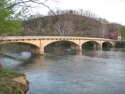
Alderson Bridge, Road bridge in Alderson, West Virginia, United States.

Description

Alderson Bridge is a concrete arch bridge crossing the Greenbrier River with a span of roughly 450 feet (137 meters). The structure includes walkways and connects two counties on either side of the water.

History

The bridge was designed and built in 1914 by architect Frank Duff McEnteer. It was created during a period when new road connections were expanding to support growing automobile use.

Culture

The bridge is part of the Alderson Historic District and reflects early automobile-era architecture that shaped the region. It demonstrates how local communities adapted their infrastructure as transportation changed.

Practical

The bridge is accessible on foot and offers a direct passage between the two riverbanks. Visitors should note that the concrete surface can become slippery when wet, so appropriate footwear is recommended.

Did you know?

The structure demonstrates early concrete arch construction techniques that set standards in 20th-century bridge engineering. Engineers like McEnteer experimented with these novel methods to create durable structures that still stand today.

Location
Inception
1914
Part of
Alderson Historic District
GPS coordinates
37.72470,-80.64330
Latest update
December 14, 2025 18:46

AroundUs brings together thousands of curated places, local tips, and hidden gems, enriched daily by 60,000 contributors worldwide. Discover all places nearby (Alderson).

Around this place
Federal Prison Camp, Alderson
United States of America

Federal Prison Camp, Alderson

2.2 km
Carnegie Hall
United States of America

Carnegie Hall

19.1 km
Rehoboth Church
United States of America

Rehoboth Church

19.2 km
Col. James Graham House
United States of America

Col. James Graham House

11.2 km
John Wesley Methodist Church
United States of America

John Wesley Methodist Church

19.3 km
Blue Sulphur Springs Pavilion
United States of America

Blue Sulphur Springs Pavilion

11.5 km
Hokes Mill Covered Bridge
United States of America

Hokes Mill Covered Bridge

10.9 km
Alexander McVeigh Miller House
United States of America

Alexander McVeigh Miller House

1.1 km
Elmwood
United States of America

Elmwood

17 km
Herns Mill Covered Bridge
United States of America

Herns Mill Covered Bridge

17.1 km
Salt Sulphur Springs Historic District
United States of America

Salt Sulphur Springs Historic District

18.4 km
Laurel Creek Covered Bridge
United States of America

Laurel Creek Covered Bridge

18.3 km
Union Historic District
United States of America

Union Historic District

17.2 km
Alderson Historic District
United States of America

Alderson Historic District

97 m
Pence Springs Hotel Historic District
United States of America

Pence Springs Hotel Historic District

8.1 km
John A. North House
United States of America

John A. North House

19.2 km
Supreme Court Library Building
United States of America

Supreme Court Library Building

19.3 km
William Gaston Caperton, Jr., House
United States of America

William Gaston Caperton, Jr., House

18.7 km
McNeer House
United States of America

McNeer House

18.1 km
Brig. Gen. John Echols House
United States of America

Brig. Gen. John Echols House

17.2 km
Ronceverte Historic District
United States of America

Ronceverte Historic District

15.7 km
Sunset Hill
United States of America

Sunset Hill

1.8 km
South Church Street Historic District
United States of America

South Church Street Historic District

18.7 km
Gov. Samuel Price House
United States of America

Gov. Samuel Price House

19.6 km
Argabrite House
United States of America

Argabrite House

858 m
Greenbrier County Courthouse
United States of America

Greenbrier County Courthouse

19.4 km
Organ Cave
United States of America

Organ Cave

18.2 km
Maple Street Historic District
United States of America

Maple Street Historic District

19.2 km
Show the full map
« Alderson Bridge - Road bridge in Alderson, West Virginia, United States » is provided by Around Us (aroundus.com). Images and texts are derived from Wikimedia project under a Creative Commons license. You are allowed to copy, distribute, and modify copies of this page, under the conditions set by the license, as long as this note is clearly visible.

Discover hidden gems everywhere you go!

From secret cafés to breathtaking viewpoints, skip the crowded tourist spots and find places that match your style. Our app makes it easy with voice search, smart filtering, route optimization, and insider tips from travelers worldwide. Download now for the complete mobile experience.

Around Us App Screenshot

A unique approach to discovering new places

Le Figaro

All the places worth exploring

France Info

A tailor-made excursion in just a few clicks

20 Minutes

Around Us
Travel Guide & Maps
Download

Send to your phone

QR Code
1

Open the camera app on your mobile.

2

Point at the QR code with your camera. A notification will appear.

3

Tap the notification to open the link.