Laurel Creek Covered Bridge

Log in to your account

AroundUs is a community-driven map of interesting places, built by curious explorers like you. It grows with every review, story, and photo you share.
Connect to save your favorite spots, contribute locations, and create personalized routes.
By continuing, you accept our Terms and Conditions and our Privacy Policy
Add to collection
Map
Suggest a change
Share

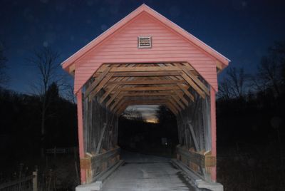
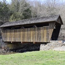
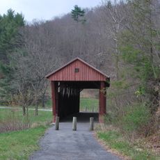
Laurel Creek Covered Bridge, Covered bridge in Lillydale, Monroe County, United States

Laurel Creek Covered Bridge is a covered bridge in West Virginia featuring red wooden siding and a galvanized metal roof that spans the creek. The structure is compact and displays the characteristic design of these historical crossing structures.

The bridge was built in 1911 with Lewis Miller constructing the stone abutments and Robert Arnott designing the structural frame. It underwent major renovation in 2000, when wooden supports were replaced with steel components.

The bridge displays early engineering work from West Virginia through its distinctive red wooden structure and the way it serves as a passage across the creek. It reflects how people in this region created river crossings during the 20th century.

The bridge is located on a county road and is relatively easy to access, though local road conditions may vary. It is best to visit during daylight hours to fully appreciate the red wooden structure.

The bridge uses a queenpost truss system with metal tension rods, which allowed an efficient design for its small size. This support system was common in early bridge engineering in West Virginia and shows how builders solved crossing problems.

Location: West Virginia

Inception: 1911

GPS coordinates: 37.56110,-80.62670

Latest update: December 14, 2025 18:10

Photos
Around this place
Federal Prison Camp, Alderson
United States of America

Federal Prison Camp, Alderson

18.4 km
Bluestone Lake
United States of America

Bluestone Lake

24.5 km
Rehoboth Church
United States of America

Rehoboth Church

11.1 km
Moncove Lake State Park
United States of America

Moncove Lake State Park

25 km
Col. James Graham House
United States of America

Col. James Graham House

13.7 km
Salt Pond Mountain
United States of America

Salt Pond Mountain

20.6 km
Cascades
United States of America

Cascades

21.7 km
Indian Creek Covered Bridge
United States of America

Indian Creek Covered Bridge

4.8 km
Hokes Mill Covered Bridge
United States of America

Hokes Mill Covered Bridge

17.6 km
Alexander McVeigh Miller House
United States of America

Alexander McVeigh Miller House

19 km
Elmwood
United States of America

Elmwood

8.6 km
Salt Sulphur Springs Historic District
United States of America

Salt Sulphur Springs Historic District

5.2 km
Cook's Mill
United States of America

Cook's Mill

5.6 km
Union Historic District
United States of America

Union Historic District

8 km
Hinton Historic District
United States of America

Hinton Historic District

26.1 km
Alderson Bridge
United States of America

Alderson Bridge

18.3 km
Alderson Historic District
United States of America

Alderson Historic District

18.3 km
Pence Springs Hotel Historic District
United States of America

Pence Springs Hotel Historic District

16 km
Doe Creek Farm
United States of America

Doe Creek Farm

26.3 km
Wallace Estill, Sr., House
United States of America

Wallace Estill, Sr., House

3.9 km
William Gaston Caperton, Jr., House
United States of America

William Gaston Caperton, Jr., House

10.6 km
McNeer House
United States of America

McNeer House

5.4 km
Brig. Gen. John Echols House
United States of America

Brig. Gen. John Echols House

8.2 km
Ronceverte Historic District
United States of America

Ronceverte Historic District

25.3 km
Sunset Hill
United States of America

Sunset Hill

16.5 km
Argabrite House
United States of America

Argabrite House

18.8 km
Organ Cave
United States of America

Organ Cave

24.2 km
Hanging Rock Raptor Observatory
United States of America

Hanging Rock Raptor Observatory

16.6 km
Show the full map
Reviews

Visited this place? Tap the stars to rate it and share your experience / photos with the community! Try now! You can cancel it anytime.

« Laurel Creek Covered Bridge - Covered bridge in Lillydale, Monroe County, United States » is provided by Around Us (aroundus.com). Images and texts are derived from Wikimedia project under a Creative Commons license. You are allowed to copy, distribute, and modify copies of this page, under the conditions set by the license, as long as this note is clearly visible.

Discover hidden gems everywhere you go!

From secret cafés to breathtaking viewpoints, skip the crowded tourist spots and find places that match your style. Our app makes it easy with voice search, smart filtering, route optimization, and insider tips from travelers worldwide. Download now for the complete mobile experience.

Around Us App Screenshot

A unique approach to discovering new places

Le Figaro

All the places worth exploring

France Info

A tailor-made excursion in just a few clicks

20 Minutes