Enable Location

We need your location to show you interesting places around you

Discover nearby places

Find interesting locations and hidden gems around you

Precise directions

Get accurate directions and distances to places

Your location is never shared with other users. It's only used when you tap the location button.

Cook's Mill

Log in to your account

Start exploring — it's free

Trusted by 61,515 travelers worldwide

Continue with Google
Continue with Apple
or

We will send you a code to connect

By continuing, you accept our Terms and Conditions and our Privacy Policy

Check your inbox

We've sent a pincode in your inbox. Please enter the code below.

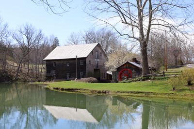
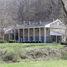
Cook's Mill, Historic district in Greenville, United States.

Description

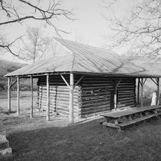
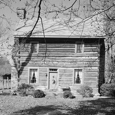
Cook's Mill is a historic district in Greenville comprising multiple structures built around the original milling site. The main building rises 2.5 stories with hand-hewn post-and-beam construction joined by mortise and tenon joints, while a dam, mill pond, and water channels make up the supporting infrastructure that powered the 19th-century operation.

History

An earlier mill operated at this location from 1796, establishing the foundation upon which the current complex was built in 1857 on its stone base. This continuity of water-powered milling across generations shows the industrial development of Monroe County.

Culture

The location was the setting for one of the first recorded marriages in Monroe County in 1780, between Phillip Hamman and Christina Cook. This early union shows that people gathered here to mark important moments in their lives.

Practical

The district can be explored by walking around the various structures and features spread across the property. Visitors should check on-site information since some historic buildings may have restricted access or limited viewing areas.

Did you know?

Phillip Hamman, a key figure connected to this location, earned the title Savior of the Greenbrier for warning settlements about an attack in 1778. This brave act tied his name to the survival story of the early community.

Location
GPS coordinates
37.54500,-80.68720
Latest update
December 14, 2025 18:10

AroundUs brings together thousands of curated places, local tips, and hidden gems, enriched daily by 60,000 contributors worldwide. Discover all places nearby (West Virginia).

Around this place
Federal Prison Camp, Alderson
United States of America

Federal Prison Camp, Alderson

20 km
Bluestone Lake
United States of America

Bluestone Lake

20.5 km
Bluestone State Park
United States of America

Bluestone State Park

23.6 km
Rehoboth Church
United States of America

Rehoboth Church

16.7 km
Col. James Graham House
United States of America

Col. James Graham House

12.5 km
Salt Pond Mountain
United States of America

Salt Pond Mountain

22.8 km
Cascades
United States of America

Cascades

21.3 km
Indian Creek Covered Bridge
United States of America

Indian Creek Covered Bridge

9.9 km
Hokes Mill Covered Bridge
United States of America

Hokes Mill Covered Bridge

22.2 km
Alexander McVeigh Miller House
United States of America

Alexander McVeigh Miller House

21.3 km
Elmwood
United States of America

Elmwood

14.2 km
Summers County Courthouse
United States of America

Summers County Courthouse

22.9 km
Salt Sulphur Springs Historic District
United States of America

Salt Sulphur Springs Historic District

10.8 km
Laurel Creek Covered Bridge
United States of America

Laurel Creek Covered Bridge

5.6 km
Union Historic District
United States of America

Union Historic District

13.7 km
Hinton Historic District
United States of America

Hinton Historic District

22.7 km
Alderson Bridge
United States of America

Alderson Bridge

20.4 km
Andrew Johnston House
United States of America

Andrew Johnston House

24.5 km
Alderson Historic District
United States of America

Alderson Historic District

20.4 km
Pence Springs Hotel Historic District
United States of America

Pence Springs Hotel Historic District

15.8 km
Jordan's Chapel
United States of America

Jordan's Chapel

24.1 km
Wallace Estill, Sr., House
United States of America

Wallace Estill, Sr., House

5.6 km
William Gaston Caperton, Jr., House
United States of America

William Gaston Caperton, Jr., House

16.2 km
McNeer House
United States of America

McNeer House

11 km
Brig. Gen. John Echols House
United States of America

Brig. Gen. John Echols House

13.8 km
Sunset Hill
United States of America

Sunset Hill

18.7 km
Argabrite House
United States of America

Argabrite House

21.1 km
Hanging Rock Raptor Observatory
United States of America

Hanging Rock Raptor Observatory

21.2 km
Show the full map
« Cook's Mill - Historic district in Greenville, United States » is provided by Around Us (aroundus.com). Images and texts are derived from Wikimedia project under a Creative Commons license. You are allowed to copy, distribute, and modify copies of this page, under the conditions set by the license, as long as this note is clearly visible.

Discover hidden gems everywhere you go!

From secret cafés to breathtaking viewpoints, skip the crowded tourist spots and find places that match your style. Our app makes it easy with voice search, smart filtering, route optimization, and insider tips from travelers worldwide. Download now for the complete mobile experience.

Around Us App Screenshot

A unique approach to discovering new places

Le Figaro

All the places worth exploring

France Info

A tailor-made excursion in just a few clicks

20 Minutes

Around Us
Travel Guide & Maps
Download

Send to your phone

QR Code
1

Open the camera app on your mobile.

2

Point at the QR code with your camera. A notification will appear.

3

Tap the notification to open the link.