Enable Location

We need your location to show you interesting places around you

Discover nearby places

Find interesting locations and hidden gems around you

Precise directions

Get accurate directions and distances to places

Your location is never shared with other users. It's only used when you tap the location button.

Hokes Mill Covered Bridge

Log in to your account

Start exploring — it's free

Trusted by 62,520 travelers worldwide

Continue with Google
Continue with Apple
or

We will send you a code to connect

By continuing, you accept our Terms and Conditions and our Privacy Policy

Check your inbox

We've sent a pincode in your inbox. Please enter the code below.

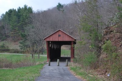
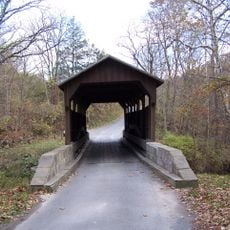
Hokes Mill Covered Bridge, Covered bridge in Greenbrier County, United States.

The Hokes Mill Covered Bridge is a wooden covered structure crossing Second Creek in Greenbrier County, West Virginia. It features distinctive red board-and-batten siding and a span of about 81.6 feet with a width of 12 feet.

The bridge was built between 1897 and 1899 using construction methods typical of late 19th-century rural engineering. It gained recognition on the National Register of Historic Places in 1981, acknowledging its historical value.

The red wooden structure reflects how such crossings once served as vital links in rural communities, connecting distant farms and villages. Walking through it today offers a sense of the everyday transportation methods that shaped life in the countryside.

The bridge is located on County Route 62 and remains accessible for visitors interested in examining its construction up close. Plan to walk through it slowly to appreciate the wooden details and craftsmanship visible throughout the structure.

It uses a Long Truss design, a specific construction method that was not commonly seen in this region. This technique allowed builders to span longer distances using mostly wood, without relying on heavy iron reinforcements.

The community of curious travelers

AroundUs brings together thousands of curated places, local tips, and hidden gems, enriched daily by 60,000 contributors worldwide.

Start exploring
Inception
1899
GPS coordinates
37.69722,-80.52500
Latest update
December 14, 2025 16:40
Around this place
Federal Prison Camp, Alderson
United States of America

Federal Prison Camp, Alderson

12.9 km
Lost World Caverns
United States of America

Lost World Caverns

16.6 km
Carnegie Hall
United States of America

Carnegie Hall

13.4 km
Rehoboth Church
United States of America

Rehoboth Church

12 km
John Wesley Methodist Church
United States of America

John Wesley Methodist Church

13.4 km
Alexander McVeigh Miller House
United States of America

Alexander McVeigh Miller House

10.4 km
Elmwood
United States of America

Elmwood

11.4 km
Herns Mill Covered Bridge
United States of America

Herns Mill Covered Bridge

15.2 km
Salt Sulphur Springs Historic District
United States of America

Salt Sulphur Springs Historic District

14.7 km
Union Historic District
United States of America

Union Historic District

11.9 km
Alderson Bridge
United States of America

Alderson Bridge

10.9 km
Alderson Historic District
United States of America

Alderson Historic District

10.8 km
Pence Springs Hotel Historic District
United States of America

Pence Springs Hotel Historic District

17.2 km
John A. North House
United States of America

John A. North House

13.6 km
Supreme Court Library Building
United States of America

Supreme Court Library Building

13.6 km
William Gaston Caperton, Jr., House
United States of America

William Gaston Caperton, Jr., House

11.7 km
McNeer House
United States of America

McNeer House

14.3 km
Brig. Gen. John Echols House
United States of America

Brig. Gen. John Echols House

11.8 km
Ronceverte Historic District
United States of America

Ronceverte Historic District

7.8 km
Sunset Hill
United States of America

Sunset Hill

10.1 km
South Church Street Historic District
United States of America

South Church Street Historic District

12.9 km
Gov. Samuel Price House
United States of America

Gov. Samuel Price House

13.9 km
Argabrite House
United States of America

Argabrite House

10.4 km
Greenbrier County Courthouse
United States of America

Greenbrier County Courthouse

13.7 km
Organ Cave
United States of America

Organ Cave

8.1 km
Lewisburg Historic District
United States of America

Lewisburg Historic District

16.1 km
James Withrow House
United States of America

James Withrow House

13.9 km
Maple Street Historic District
United States of America

Maple Street Historic District

13.7 km
Show the full map
« Hokes Mill Covered Bridge - Covered bridge in Greenbrier County, United States » is provided by Around Us (aroundus.com). Images and texts are derived from Wikimedia project under a Creative Commons license. You are allowed to copy, distribute, and modify copies of this page, under the conditions set by the license, as long as this note is clearly visible.

Discover hidden gems everywhere you go!

From secret cafés to breathtaking viewpoints, skip the crowded tourist spots and find places that match your style. Our app makes it easy with voice search, smart filtering, route optimization, and insider tips from travelers worldwide. Download now for the complete mobile experience.

Around Us App Screenshot

A unique approach to discovering new places

Le Figaro

All the places worth exploring

France Info

A tailor-made excursion in just a few clicks

20 Minutes

Around Us
Travel Guide & Maps
Download

Send to your phone

QR Code
1

Open the camera app on your mobile.

2

Point at the QR code with your camera. A notification will appear.

3

Tap the notification to open the link.