Enable Location

We need your location to show you interesting places around you

Discover nearby places

Find interesting locations and hidden gems around you

Precise directions

Get accurate directions and distances to places

Your location is never shared with other users. It's only used when you tap the location button.

Indian Creek Covered Bridge

Log in to your account

Start exploring — it's free

Trusted by 63,115 travelers worldwide

Continue with Google
Continue with Apple
or

We will send you a code to connect

By continuing, you accept our Terms and Conditions and our Privacy Policy

Check your inbox

We've sent a pincode in your inbox. Please enter the code below.

Discussion Reviews 1 Photos
1.6k Popularity

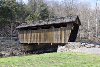
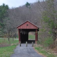
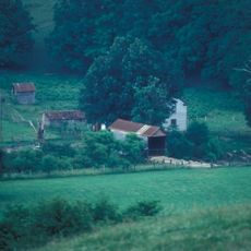
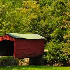
Indian Creek Covered Bridge, Wooden covered bridge in Monroe County, United States

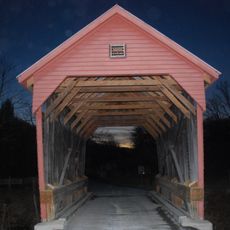
The Indian Creek Covered Bridge is a wooden crossing that spans a stream with an interior truss framework and a protective roof structure. The covered design protects the wooden components from weather and decay while allowing pedestrians and vehicles to pass through.

The structure was built during the 1890s and served as an important local crossing until a larger highway project reduced its role in transportation. It remained standing and was eventually recognized for its historical significance decades later.

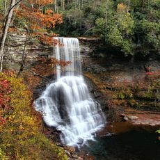
The bridge demonstrates how rural communities relied on such structures to connect across waterways before modern roads existed. It reflects the craftsmanship and practical engineering methods that shaped daily life in the region.

The crossing is accessible by foot or vehicle, though the interior passage is narrow and requires careful navigation. Visitors should move slowly through the structure and be prepared for uneven wooden flooring.

Two young craftsmen built this bridge in the late 1800s before it lost its role as a main crossing within a few decades. Their construction withstood time and eventually earned recognition as a historical landmark worth preserving.

The community of curious travelers

AroundUs brings together thousands of curated places, local tips, and hidden gems, enriched daily by 60,000 contributors worldwide.

Start exploring
Location
Inception
1898
GPS coordinates
37.54684,-80.57558
Latest update
December 14, 2025 13:02
Around this place
Federal Prison Camp, Alderson
United States of America

Federal Prison Camp, Alderson

21.3 km
Rehoboth Church
United States of America

Rehoboth Church

7.7 km
Moncove Lake State Park
United States of America

Moncove Lake State Park

21.2 km
Col. James Graham House
United States of America

Col. James Graham House

18 km
Salt Pond Mountain
United States of America

Salt Pond Mountain

17 km
Cascades
United States of America

Cascades

20 km
Hokes Mill Covered Bridge
United States of America

Hokes Mill Covered Bridge

17.3 km
Alexander McVeigh Miller House
United States of America

Alexander McVeigh Miller House

21.2 km
Elmwood
United States of America

Elmwood

6.3 km
Salt Sulphur Springs Historic District
United States of America

Salt Sulphur Springs Historic District

2.6 km
Laurel Creek Covered Bridge
United States of America

Laurel Creek Covered Bridge

4.8 km
Cook's Mill
United States of America

Cook's Mill

9.9 km
Union Historic District
United States of America

Union Historic District

5.7 km
Alderson Bridge
United States of America

Alderson Bridge

20.7 km
Alderson Historic District
United States of America

Alderson Historic District

20.7 km
Pence Springs Hotel Historic District
United States of America

Pence Springs Hotel Historic District

19.9 km
Doe Creek Farm
United States of America

Doe Creek Farm

24.4 km
Wallace Estill, Sr., House
United States of America

Wallace Estill, Sr., House

5.2 km
William Gaston Caperton, Jr., House
United States of America

William Gaston Caperton, Jr., House

7.5 km
McNeer House
United States of America

McNeer House

3.1 km
Brig. Gen. John Echols House
United States of America

Brig. Gen. John Echols House

5.9 km
Ronceverte Historic District
United States of America

Ronceverte Historic District

24.5 km
Sunset Hill
United States of America

Sunset Hill

18.9 km
Greater Newport Rural Historic District
United States of America

Greater Newport Rural Historic District

27 km
Argabrite House
United States of America

Argabrite House

21.1 km
Organ Cave
United States of America

Organ Cave

22.6 km
Hanging Rock Raptor Observatory
United States of America

Hanging Rock Raptor Observatory

11.8 km
Link Farm Covered Bridge
United States of America

Link Farm Covered Bridge

26.8 km
Show the full map
Reviews
Share your experience

No review yet

Discussions
Start a discussion...

No discussion yet

« Indian Creek Covered Bridge - Wooden covered bridge in Monroe County, United States » is provided by Around Us (aroundus.com). Images and texts are derived from Wikimedia project under a Creative Commons license. You are allowed to copy, distribute, and modify copies of this page, under the conditions set by the license, as long as this note is clearly visible.

Discover hidden gems everywhere you go!

From secret cafés to breathtaking viewpoints, skip the crowded tourist spots and find places that match your style. Our app makes it easy with voice search, smart filtering, route optimization, and insider tips from travelers worldwide. Download now for the complete mobile experience.

Around Us App Screenshot

A unique approach to discovering new places

Le Figaro

All the places worth exploring

France Info

A tailor-made excursion in just a few clicks

20 Minutes

Around Us
Travel Guide & Maps
Download

Send to your phone

QR Code
1

Open the camera app on your mobile.

2

Point at the QR code with your camera. A notification will appear.

3

Tap the notification to open the link.