Enable Location

We need your location to show you interesting places around you

Discover nearby places

Find interesting locations and hidden gems around you

Precise directions

Get accurate directions and distances to places

Your location is never shared with other users. It's only used when you tap the location button.

Barry Farm

Log in to your account

Start exploring — it's free

Trusted by 63,074 travelers worldwide

Continue with Google
Continue with Apple
or

We will send you a code to connect

By continuing, you accept our Terms and Conditions and our Privacy Policy

Check your inbox

We've sent a pincode in your inbox. Please enter the code below.

Barry Farm
Discussion Reviews 1 Photos
16.7k Popularity

Barry Farm, Historic African American settlement in Southeast Washington, United States

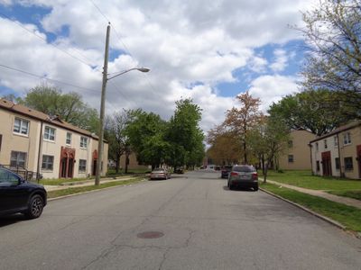
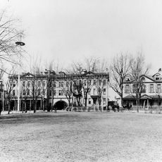
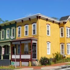
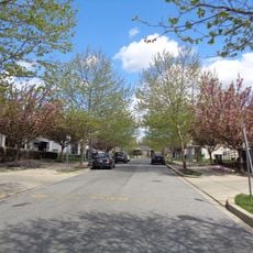
Barry Farm is a neighborhood that spans several blocks east of the Anacostia River, bordered by the Southeast Freeway and Suitland Parkway. The area consists of residential blocks, streets, and community facilities that reflect the everyday life of residents.

The Freedmen's Bureau purchased 375 acres from Julia Barry in 1867 to establish a settlement for formerly enslaved people seeking independence. This founding represented a significant step toward self-determination and economic self-sufficiency for Black communities after emancipation.

The street names honor Union generals and Freedmen's Bureau officials who supported Black Americans during the Civil War era. This naming reflects how the community maintains its connection to its freedom history.

The neighborhood maintains connections to downtown Washington through public transportation and provides access to community services. Visitors can best explore the area on foot to take in the street layout and residential character of the blocks.

Residents of Barry Farm led successful protests in 1949 that helped bring about the desegregation of public swimming pools in Washington. These actions demonstrated how the community took a stand for its rights and created change in the city.

The community of curious travelers

AroundUs brings together thousands of curated places, local tips, and hidden gems, enriched daily by 60,000 contributors worldwide.

Start exploring
Location
GPS coordinates
38.85842,-76.99694
Latest update
December 7, 2025 19:26
Around this place
Washington Navy Yard
United States of America

Washington Navy Yard

1.7 km
Anacostia
United States of America

Anacostia

1.3 km
National Museum of the United States Navy
United States of America

National Museum of the United States Navy

1.7 km
Frederick Douglass National Historic Site
United States of America

Frederick Douglass National Historic Site

1.1 km
Navy Yard
United States of America

Navy Yard

1.7 km
Buzzard Point
United States of America

Buzzard Point

1.6 km
Douglas A. Munro Coast Guard Headquarters Building
United States of America

Douglas A. Munro Coast Guard Headquarters Building

789 m
Tingey House
United States of America

Tingey House

2 km
11th Street Bridges
United States of America

11th Street Bridges

1.7 km
Frederick Douglass Memorial Bridge
United States of America

Frederick Douglass Memorial Bridge

1.3 km
Anacostia Community Museum
United States of America

Anacostia Community Museum

1.7 km
The Big Chair
United States of America

The Big Chair

1 km
Officers Quarters, Washington Navy Yard
United States of America

Officers Quarters, Washington Navy Yard

2 km
Latrobe Gate
United States of America

Latrobe Gate

2 km
Anacostia Historic District
United States of America

Anacostia Historic District

1.3 km
Marine Corps Museum
United States of America

Marine Corps Museum

1.9 km
Roosevelt Hall
United States of America

Roosevelt Hall

1.8 km
Douglass
United States of America

Douglass

1.9 km
The Yards
United States of America

The Yards

1.7 km
Building 170
United States of America

Building 170

1.9 km
Fort Stanton
United States of America

Fort Stanton

1.7 km
James C. Dent House
United States of America

James C. Dent House

2 km
Commandant's Office, Washington Navy Yard
United States of America

Commandant's Office, Washington Navy Yard

1.6 km
District of Columbia Main Sewerage Pumping Station
United States of America

District of Columbia Main Sewerage Pumping Station

1.8 km
Carver Theater
United States of America

Carver Theater

621 m
Anacostia Neighborhood Library
United States of America

Anacostia Neighborhood Library

1.8 km
Bet Mishpachah Cemetery
United States of America

Bet Mishpachah Cemetery

1.6 km
Buzzard Point Power Plant
United States of America

Buzzard Point Power Plant

1.5 km
Show the full map
Reviews
Share your experience

No review yet

Discussions
Start a discussion...

No discussion yet

« Barry Farm - Historic African American settlement in Southeast Washington, United States » is provided by Around Us (aroundus.com). Images and texts are derived from Wikimedia project under a Creative Commons license. You are allowed to copy, distribute, and modify copies of this page, under the conditions set by the license, as long as this note is clearly visible.

Discover hidden gems everywhere you go!

From secret cafés to breathtaking viewpoints, skip the crowded tourist spots and find places that match your style. Our app makes it easy with voice search, smart filtering, route optimization, and insider tips from travelers worldwide. Download now for the complete mobile experience.

Around Us App Screenshot

A unique approach to discovering new places

Le Figaro

All the places worth exploring

France Info

A tailor-made excursion in just a few clicks

20 Minutes

Around Us
Travel Guide & Maps
Download

Send to your phone

QR Code
1

Open the camera app on your mobile.

2

Point at the QR code with your camera. A notification will appear.

3

Tap the notification to open the link.