Enable Location

We need your location to show you interesting places around you

Discover nearby places

Find interesting locations and hidden gems around you

Precise directions

Get accurate directions and distances to places

Your location is never shared with other users. It's only used when you tap the location button.

Bartram's Covered Bridge

Log in to your account

Start exploring — it's free

Trusted by 61,462 travelers worldwide

Continue with Google
Continue with Apple
or

We will send you a code to connect

By continuing, you accept our Terms and Conditions and our Privacy Policy

Check your inbox

We've sent a pincode in your inbox. Please enter the code below.

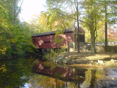
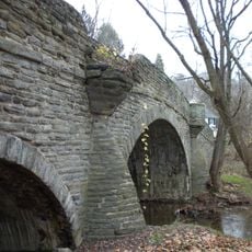
Bartram's Covered Bridge, Covered bridge in Newtown Township, Pennsylvania, US

Description

Bartram's Covered Bridge is a wooden structure that spans Crum Creek in Newtown Township, Pennsylvania. The construction uses a Burr Truss design and connects Goshen Road between Delaware and Chester County with a span of approximately 30 feet.

History

The bridge was built in 1860 by Ferdinand Wood and is one of the last survivors of the original 30 covered bridges that once stood in Delaware County. Its construction dates from a period when such structures were essential for connecting communities across the region.

Culture

The bridge dimensions were specifically determined to accommodate a load of hay, reflecting the agricultural needs of the local community during its construction.

Practical

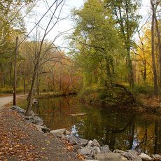
The bridge stands beside a modern bridge and remains accessible for pedestrians year-round. It is advisable to wear sturdy shoes, as the wooden surface can become slippery, especially in wet weather.

Did you know?

The bridge features distinctly slanted planks at each entrance, a characteristic found in no other covered bridge across Pennsylvania. These details help visitors recognize it immediately as a special historical structure.

Location
GPS coordinates
39.98972,-75.43750
Latest update
December 14, 2025 11:06

AroundUs brings together thousands of curated places, local tips, and hidden gems, enriched daily by 60,000 contributors worldwide. Discover all places nearby (Pennsylvania).

Around this place
Chanticleer Garden
United States of America

Chanticleer Garden

6.3 km
Chanticleer Garden
United States of America

Chanticleer Garden

6.1 km
Ridley Creek State Park
United States of America

Ridley Creek State Park

3.9 km
St. David's Episcopal Church
United States of America

St. David's Episcopal Church

5 km
John J. Tyler Arboretum
United States of America

John J. Tyler Arboretum

6.1 km
Thomas Massey House
United States of America

Thomas Massey House

7.4 km
Waynesborough
United States of America

Waynesborough

5.6 km
Square Tavern
United States of America

Square Tavern

2.6 km
Camp-Woods
United States of America

Camp-Woods

7.2 km
Radnor Friends Meetinghouse
United States of America

Radnor Friends Meetinghouse

7.7 km
Squire Cheyney Farm
United States of America

Squire Cheyney Farm

7.3 km
United States of America

Newtown Square Friends Meeting House

2.8 km
Bridge in Radnor Township No. 1
United States of America

Bridge in Radnor Township No. 1

5.8 km
South Wayne Historic District
United States of America

South Wayne Historic District

7.2 km
Old Eagle School
United States of America

Old Eagle School

7.4 km
Waterloo Mills Historic District
United States of America

Waterloo Mills Historic District

4.1 km
Downtown Wayne Historic District
United States of America

Downtown Wayne Historic District

7.6 km
Cramond
United States of America

Cramond

7.3 km
Roughwood
United States of America

Roughwood

6.8 km
Saturday Club
United States of America

Saturday Club

7.3 km
Garrett Farmstead
United States of America

Garrett Farmstead

4.4 km
White Horse Historic District
United States of America

White Horse Historic District

2.7 km
Ellis Williams House
United States of America

Ellis Williams House

7.9 km
Crosley–Garrett Mill Workers' Housing, Store, and Mill Site
United States of America

Crosley–Garrett Mill Workers' Housing, Store, and Mill Site

4.3 km
Wetherby-Hampton-Snyder-Wilson-Erdman Log House
United States of America

Wetherby-Hampton-Snyder-Wilson-Erdman Log House

6.9 km
Regal Edgmont Square 10
United States of America

Regal Edgmont Square 10

1.6 km
Anthony Wayne Theatre
United States of America

Anthony Wayne Theatre

7.4 km
Okehocking Historic District
United States of America

Okehocking Historic District

6.2 km
Show the full map
« Bartram's Covered Bridge - Covered bridge in Newtown Township, Pennsylvania, US » is provided by Around Us (aroundus.com). Images and texts are derived from Wikimedia project under a Creative Commons license. You are allowed to copy, distribute, and modify copies of this page, under the conditions set by the license, as long as this note is clearly visible.

Discover hidden gems everywhere you go!

From secret cafés to breathtaking viewpoints, skip the crowded tourist spots and find places that match your style. Our app makes it easy with voice search, smart filtering, route optimization, and insider tips from travelers worldwide. Download now for the complete mobile experience.

Around Us App Screenshot

A unique approach to discovering new places

Le Figaro

All the places worth exploring

France Info

A tailor-made excursion in just a few clicks

20 Minutes

Around Us
Travel Guide & Maps
Download

Send to your phone

QR Code
1

Open the camera app on your mobile.

2

Point at the QR code with your camera. A notification will appear.

3

Tap the notification to open the link.