Chest opened
+${chestReward.xp} XP
Explorer
NOUVEAU ×${chestReward.collectible.quantity}
tapez pour fermer
Chest locked

Open chests in the app

Around Us is built for your phone — chests unlock when you walk, explore and capture nearby places.

Enable Location

We need your location to show you interesting places around you

Discover nearby places

Find interesting locations and hidden gems around you

Precise directions

Get accurate directions and distances to places

Your location is never shared with other users. It's only used when you tap the location button.

Big Blue River

Log in to your account

Start exploring — it's free

Trusted by 72,887 travelers worldwide

Continue with Google
Continue with Apple
or

We will send you a code to connect

By continuing, you accept our Terms and Conditions and our Privacy Policy

Check your inbox

We've sent a pincode in your inbox. Please enter the code below.

Big Blue River
Discussion Reviews 1 Photos
9.3k Popularity

Big Blue River, Major tributary river between Manhattan, Nebraska and Kansas, US

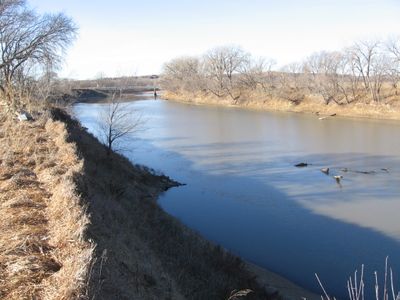
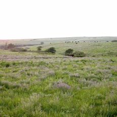
Big Blue River is a waterway flowing roughly 359 miles from central Nebraska southeastward through Kansas, where it joins the Kansas River near Manhattan. The river cuts through plains and gentle hills, creating a natural corridor that shapes the landscape it passes through.

The river served as a key reference point for people moving through the region and establishing settlements over time. Its reliable water supply and natural curves influenced where communities developed and how they used the land.

The river formed a section of the Oregon Trail, guiding pioneers westward from Independence and Kansas City through Nebraska territory.

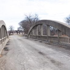
The water is used mainly for irrigation of farmland, especially during warmer months when demand is greatest. Visitors can see and access the river at several points along public roads and bridges throughout the region.

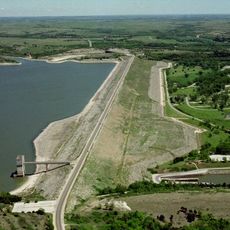
The river feeds into a large reservoir before reaching its endpoint, storing water for multiple purposes in the process. This lake was constructed using materials sourced directly from the surrounding land.

The community of curious travelers

AroundUs brings together thousands of curated places, local tips, and hidden gems, enriched daily by 60,000 contributors worldwide.

Start exploring
Location
Location
Elevation above the sea
304 m
GPS coordinates
39.18694,-96.53028
Latest update
December 10, 2025 15:58
Around this place
Bill Snyder Family Football Stadium
United States of America

Bill Snyder Family Football Stadium

5.7 km
Tuttle Creek Lake
United States of America

Tuttle Creek Lake

20.1 km
Johnny Kaw
United States of America

Johnny Kaw

3.8 km
World War I Memorial Stadium
United States of America

World War I Memorial Stadium

4.7 km
Konza Prairie
United States of America

Konza Prairie

10.7 km
Beecher Bible and Rifle Church
United States of America

Beecher Bible and Rifle Church

16.6 km
Flint Hills Discovery Center
United States of America

Flint Hills Discovery Center

2.8 km
United States of America

Sunset Zoo

5.8 km
First Territorial Capitol of Kansas
United States of America

First Territorial Capitol of Kansas

23 km
Hale Library
United States of America

Hale Library

4.4 km
Oz Museum
United States of America

Oz Museum

19.5 km
Anderson Hall
United States of America

Anderson Hall

4.3 km
Seven Dolors Catholic Church
United States of America

Seven Dolors Catholic Church

3.2 km
Seaton Hall
United States of America

Seaton Hall

4.5 km
Goodnow House
United States of America

Goodnow House

5.6 km
First Congregational Church
United States of America

First Congregational Church

3.2 km
Dickens Hall
United States of America

Dickens Hall

4.2 km
Manhattan Carnegie Library Building
United States of America

Manhattan Carnegie Library Building

3.2 km
Conroe Bridge
United States of America

Conroe Bridge

23.2 km
Downtown Manhattan Historic District
United States of America

Downtown Manhattan Historic District

2.9 km
Jeremiah Platt House
United States of America

Jeremiah Platt House

5.2 km
E. A. and Ura Wharton House
United States of America

E. A. and Ura Wharton House

3.1 km
George and Virginia Trout House
United States of America

George and Virginia Trout House

19.4 km
Cassius & Adelia Baker House
United States of America

Cassius & Adelia Baker House

19.4 km
Bluemont Hall
United States of America

Bluemont Hall

4.2 km
Woman's Club House
United States of America

Woman's Club House

3.6 km
Cardwell Hall
United States of America

Cardwell Hall

4.5 km
Houston and Pierre Streets Residential Historic District
United States of America

Houston and Pierre Streets Residential Historic District

3.3 km
Show the full map
Reviews
Share your experience

No review yet

Discussions
Start a discussion...

No discussion yet

« Big Blue River - Major tributary river between Manhattan, Nebraska and Kansas, US » is provided by Around Us (aroundus.com). Images and texts are derived from Wikimedia project under a Creative Commons license. You are allowed to copy, distribute, and modify copies of this page, under the conditions set by the license, as long as this note is clearly visible.

Discover hidden gems everywhere you go!

From secret cafés to breathtaking viewpoints, skip the crowded tourist spots and find places that match your style. Our app makes it easy with voice search, smart filtering, route optimization, and insider tips from travelers worldwide. Download now for the complete mobile experience.

Around Us App Screenshot

A unique approach to discovering new places

Le Figaro

All the places worth exploring

France Info

A tailor-made excursion in just a few clicks

20 Minutes

Around Us
Travel Guide & Maps
Download

Send to your phone

QR Code
1

Open the camera app on your mobile.

2

Point at the QR code with your camera. A notification will appear.

3

Tap the notification to open the link.