Enable Location

We need your location to show you interesting places around you

Discover nearby places

Find interesting locations and hidden gems around you

Precise directions

Get accurate directions and distances to places

Your location is never shared with other users. It's only used when you tap the location button.

Bradford Old City Hall

Log in to your account

Start exploring — it's free

Trusted by 61,340 travelers worldwide

Continue with Google
Continue with Apple
or

We will send you a code to connect

By continuing, you accept our Terms and Conditions and our Privacy Policy

Check your inbox

We've sent a pincode in your inbox. Please enter the code below.

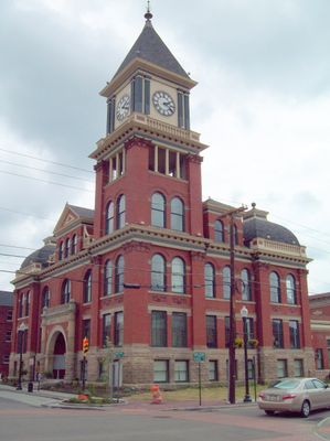
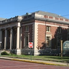
Bradford Old City Hall, Victorian municipal building in Bradford, Pennsylvania

Description

Bradford Old City Hall is a Victorian municipal building in Bradford, Pennsylvania, with a red brick facade and a prominent four-story clock tower extending 100 feet above street level. The tower features ornamental stone accents and displays a four-dial Seth Thomas clock that has marked the town's time for generations.

History

Architect Enoch Curtis designed this municipal building in 1897 to serve Bradford's growing community. Following a destructive fire in 1902, Curtis oversaw the rebuilding effort, which restored the building and ensured its continued role as the center of city government.

Culture

The building displays Victorian architectural details that reflect how Bradford's community valued impressive civic spaces during its growth period. Visitors can observe the craftsmanship in decorative elements throughout the interior.

Practical

The building is located in downtown Bradford and houses active city government offices, making it an accessible landmark for visitors exploring the town center. The prominent clock tower serves as a helpful orientation point when navigating the downtown area.

Did you know?

The building's transformation after the 1902 fire was so thorough that much of what visitors see today is reconstruction rather than original material. This rebuild demonstrates how communities of that era recovered from disaster and reimagined their civic spaces.

Location
Architectural style
Victorian architecture
GPS coordinates
41.95694,-78.64764
Latest update
December 14, 2025 18:11

AroundUs brings together thousands of curated places, local tips, and hidden gems, enriched daily by 60,000 contributors worldwide. Discover all places nearby (Pennsylvania).

Around this place
Kinzua Dam
United States of America

Kinzua Dam

32.3 km
Kinzua Bridge State Park
United States of America

Kinzua Bridge State Park

23.1 km
Allegany State Park
United States of America

Allegany State Park

18.6 km
Allegheny Reservoir
United States of America

Allegheny Reservoir

32.4 km
Eldred World War II Museum
United States of America

Eldred World War II Museum

21.7 km
Lynn Hall
United States of America

Lynn Hall

31.7 km
Olean Public Library
United States of America

Olean Public Library

22.4 km
Temple B'Nai Israel
United States of America

Temple B'Nai Israel

22.5 km
Conklin Mountain House
United States of America

Conklin Mountain House

22.7 km
Rufus Barrett Stone House
United States of America

Rufus Barrett Stone House

185 m
Beardsley-Oliver House
United States of America

Beardsley-Oliver House

22.7 km
Bradford Downtown Historic District
United States of America

Bradford Downtown Historic District

287 m
Crook Farm
United States of America

Crook Farm

4.2 km
Olean School No. 10
United States of America

Olean School No. 10

22 km
Pfeiffer-Wheeler American Chestnut Cabin
United States of America

Pfeiffer-Wheeler American Chestnut Cabin

30.5 km
Union and State Streets Historic District
United States of America

Union and State Streets Historic District

22.3 km
Bedford Corners Historic District
United States of America

Bedford Corners Historic District

29.9 km
William E. Wheeler House
United States of America

William E. Wheeler House

27.2 km
Portville Free Library
United States of America

Portville Free Library

27 km
House at 520 Hostageh Road
United States of America

House at 520 Hostageh Road

15.9 km
St. Mary of the Angels Basilica
United States of America

St. Mary of the Angels Basilica

22.2 km
Seneca Iroquois National Museum
United States of America

Seneca Iroquois National Museum

23.9 km
Rimrock Trail
United States of America

Rimrock Trail

27.7 km
Bradfords Main Street Movie House
United States of America

Bradfords Main Street Movie House

134 m
Oak Hill Park Historic District
United States of America

Oak Hill Park Historic District

22.4 km
Allegheny National Forest Visitors Bureau
United States of America

Allegheny National Forest Visitors Bureau

257 m
James Morrison Memorial Bridge
United States of America

James Morrison Memorial Bridge

28 km
St. Bernard Roman Catholic Church
United States of America

St. Bernard Roman Catholic Church

261 m
Show the full map
« Bradford Old City Hall - Victorian municipal building in Bradford, Pennsylvania » is provided by Around Us (aroundus.com). Images and texts are derived from Wikimedia project under a Creative Commons license. You are allowed to copy, distribute, and modify copies of this page, under the conditions set by the license, as long as this note is clearly visible.

Discover hidden gems everywhere you go!

From secret cafés to breathtaking viewpoints, skip the crowded tourist spots and find places that match your style. Our app makes it easy with voice search, smart filtering, route optimization, and insider tips from travelers worldwide. Download now for the complete mobile experience.

Around Us App Screenshot

A unique approach to discovering new places

Le Figaro

All the places worth exploring

France Info

A tailor-made excursion in just a few clicks

20 Minutes

Around Us
Travel Guide & Maps
Download

Send to your phone

QR Code
1

Open the camera app on your mobile.

2

Point at the QR code with your camera. A notification will appear.

3

Tap the notification to open the link.