Chest opened
+${chestReward.xp} XP
Explorer
NOUVEAU ×${chestReward.collectible.quantity}
tapez pour fermer
Chest locked

Open chests in the app

Around Us is built for your phone — chests unlock when you walk, explore and capture nearby places.

Enable Location

We need your location to show you interesting places around you

Discover nearby places

Find interesting locations and hidden gems around you

Precise directions

Get accurate directions and distances to places

Your location is never shared with other users. It's only used when you tap the location button.

Log in to your account

Start exploring — it's free

Trusted by 72,881 travelers worldwide

Continue with Google
Continue with Apple
or

We will send you a code to connect

By continuing, you accept our Terms and Conditions and our Privacy Policy

Check your inbox

We've sent a pincode in your inbox. Please enter the code below.

Buckshot War
Discussion Reviews Photo
2.8k Popularity

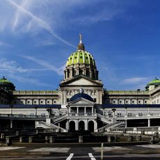
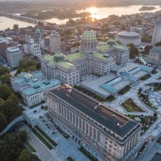
Buckshot War, Political conflict site in Harrisburg, Pennsylvania.

The Buckshot War was an armed conflict in December 1838 over control of Pennsylvania's House of Representatives, with rival factions occupying the capitol with armed men. The streets around the building grew tense as militias patrolled with loaded weapons.

The struggle began in 1838 when Whig and Democratic parties both claimed control of the House of Representatives, paralyzing government operations. A massive show of armed supporters by each side aimed to enforce their claims.

The clashes revealed a deep divide between rural and urban communities fighting for control over state politics. This tension shaped Pennsylvania's political landscape for years to come.

The State Capitol in Harrisburg is open to the public and offers tours through its historic rooms, including the House chamber. Be aware that this building still operates as the active seat of state government today.

The governor requested federal troops twice but was denied both times by Washington officials. This forced him to rely on state militia to maintain any semblance of order during the crisis.

The community of curious travelers

AroundUs brings together thousands of curated places, local tips, and hidden gems, enriched daily by 60,000 contributors worldwide.

Start exploring
Location
GPS coordinates
40.26450,-76.88350
Latest update
December 12, 2025 14:25
Around this place
Pennsylvania State Capitol
United States of America

Pennsylvania State Capitol

11 m
City Island
United States of America

City Island

1.1 km
Walnut Street Bridge
United States of America

Walnut Street Bridge

808 m
Pennsylvania State Capitol Complex
United States of America

Pennsylvania State Capitol Complex

122 m
Cumberland Valley Railroad Bridge
United States of America

Cumberland Valley Railroad Bridge

1.4 km
Whitaker Center for Science and the Arts
United States of America

Whitaker Center for Science and the Arts

515 m
United States of America

Commonwealth

14 m
Broad Street Market
United States of America

Broad Street Market

726 m
State Street Bridge
United States of America

State Street Bridge

505 m
Cathedral of Saint Patrick
United States of America

Cathedral of Saint Patrick

262 m
Susquehanna Art Museum
United States of America

Susquehanna Art Museum

882 m
Simon Cameron House
United States of America

Simon Cameron House

956 m
Ronald Reagan Federal Building
United States of America

Ronald Reagan Federal Building

328 m
Market Street Bridge
United States of America

Market Street Bridge

874 m
St. Stephen's Episcopal Cathedral
United States of America

St. Stephen's Episcopal Cathedral

477 m
Dauphin County Courthouse
United States of America

Dauphin County Courthouse

692 m
State Library of Pennsylvania
United States of America

State Library of Pennsylvania

229 m
Harris Switch Tower
United States of America

Harris Switch Tower

388 m
Mulberry Street Bridge
United States of America

Mulberry Street Bridge

810 m
Holocaust Memorial for the Commonwealth of Pennsylvania
United States of America

Holocaust Memorial for the Commonwealth of Pennsylvania

930 m
Harrisburg Midtown Arts Center
United States of America

Harrisburg Midtown Arts Center

566 m
Old Midtown Historic District
United States of America

Old Midtown Historic District

672 m
Harrisburg Technical High School
United States of America

Harrisburg Technical High School

298 m
William R. Griffith House
United States of America

William R. Griffith House

482 m
Harrisburg Historic District
United States of America

Harrisburg Historic District

608 m
William Seel Building
United States of America

William Seel Building

456 m
State Museum of Pennsylvania
United States of America

State Museum of Pennsylvania

204 m
M. Harvey Taylor Memorial Bridge
United States of America

M. Harvey Taylor Memorial Bridge

1.2 km
Show the full map
Reviews
Share your experience

No review yet

Discussions
Start a discussion...

No discussion yet

« Buckshot War - Political conflict site in Harrisburg, Pennsylvania » is provided by Around Us (aroundus.com). Images and texts are derived from Wikimedia project under a Creative Commons license. You are allowed to copy, distribute, and modify copies of this page, under the conditions set by the license, as long as this note is clearly visible.

Discover hidden gems everywhere you go!

From secret cafés to breathtaking viewpoints, skip the crowded tourist spots and find places that match your style. Our app makes it easy with voice search, smart filtering, route optimization, and insider tips from travelers worldwide. Download now for the complete mobile experience.

Around Us App Screenshot

A unique approach to discovering new places

Le Figaro

All the places worth exploring

France Info

A tailor-made excursion in just a few clicks

20 Minutes

Around Us
Travel Guide & Maps
Download

Send to your phone

QR Code
1

Open the camera app on your mobile.

2

Point at the QR code with your camera. A notification will appear.

3

Tap the notification to open the link.