Enable Location

We need your location to show you interesting places around you

Discover nearby places

Find interesting locations and hidden gems around you

Precise directions

Get accurate directions and distances to places

Your location is never shared with other users. It's only used when you tap the location button.

Burnt Island Light

Log in to your account

Start exploring — it's free

Trusted by 61,906 travelers worldwide

Continue with Google
Continue with Apple
or

We will send you a code to connect

By continuing, you accept our Terms and Conditions and our Privacy Policy

Check your inbox

We've sent a pincode in your inbox. Please enter the code below.

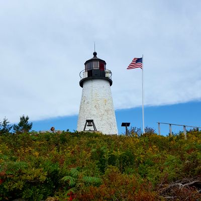
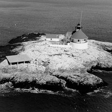
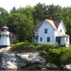
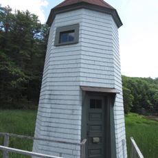
Burnt Island Light, Maritime beacon in Boothbay Harbor, United States.

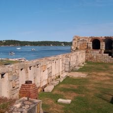
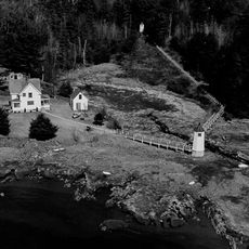
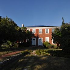
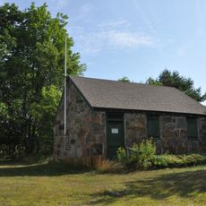
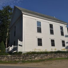
Burnt Island Light is a stone lighthouse with a white tower and black lantern room sitting on an island near Boothbay. The site includes several historic structures: the keeper's residence, a boathouse, and an oil storage building arranged around the tower.

The lighthouse was built in 1821 and is one of Maine's oldest surviving structures, originally using whale oil lamps and reflective mirrors for signaling. The complex was updated over time to incorporate modern navigation equipment.

The lighthouse demonstrates how keepers lived and worked on the island, with exhibits showing their daily responsibilities and routines. Visitors gain insight into the important role these stations played in keeping maritime traffic safe.

Visits are possible during summer months through boat tours departing from Pier 8 in Boothbay, arranged by Balmy Days Cruises. Binoculars and waterproof clothing are helpful since weather conditions on the water can change quickly.

The keeper's house dates to 1857, the boathouse to 1880, and the oil house to 1899, with each building preserved from different periods. This time span reveals how a light station's equipment and infrastructure evolved over several decades.

The community of curious travelers

AroundUs brings together thousands of curated places, local tips, and hidden gems, enriched daily by 60,000 contributors worldwide.

Start exploring
Location
Inception
1821
Height
9 m
GPS coordinates
43.82519,-69.64022
Latest update
December 12, 2025 07:54
Around this place
Pemaquid Point Light
United States of America

Pemaquid Point Light

10.9 km
Fort Popham
United States of America

Fort Popham

13.9 km
Coastal Maine Botanical Gardens
United States of America

Coastal Maine Botanical Gardens

5.8 km
Reid State Park
United States of America

Reid State Park

8.4 km
The Cuckolds Light
United States of America

The Cuckolds Light

5.1 km
Fort William Henry
United States of America

Fort William Henry

10.9 km
Pemaquid Archeological Site
United States of America

Pemaquid Archeological Site

11.2 km
Ram Island Light
United States of America

Ram Island Light

4 km
Hendricks Head Light
United States of America

Hendricks Head Light

4 km
Bosarge Family Education Center
United States of America

Bosarge Family Education Center

5.7 km
Squirrel Point Light
United States of America

Squirrel Point Light

13.1 km
Perkins Island Light
United States of America

Perkins Island Light

12.4 km
Doubling Point Range Lights
United States of America

Doubling Point Range Lights

14 km
Pythian Opera House
United States of America

Pythian Opera House

3.4 km
Auld-McCobb House
United States of America

Auld-McCobb House

3.2 km
Sproul Homestead
United States of America

Sproul Homestead

11.6 km
Boothbay Harbor Memorial Library
United States of America

Boothbay Harbor Memorial Library

3.1 km
Stephen Parsons House
United States of America

Stephen Parsons House

13.7 km
Thompson Icehouse
United States of America

Thompson Icehouse

8.8 km
Riggs-Zorach House
United States of America

Riggs-Zorach House

8.1 km
Heal Family House
United States of America

Heal Family House

9.2 km
Knight-Corey House
United States of America

Knight-Corey House

5.7 km
Benjamin Riggs House
United States of America

Benjamin Riggs House

8.4 km
Stone Schoolhouse
United States of America

Stone Schoolhouse

11.3 km
Robinhood Free Meetinghouse
United States of America

Robinhood Free Meetinghouse

8.8 km
Emily Means House
United States of America

Emily Means House

7.8 km
Doubling Point Front Range Light
United States of America

Doubling Point Front Range Light

14 km
Southport Bridge
United States of America

Southport Bridge

2.2 km
Show the full map
« Burnt Island Light - Maritime beacon in Boothbay Harbor, United States » is provided by Around Us (aroundus.com). Images and texts are derived from Wikimedia project under a Creative Commons license. You are allowed to copy, distribute, and modify copies of this page, under the conditions set by the license, as long as this note is clearly visible.

Discover hidden gems everywhere you go!

From secret cafés to breathtaking viewpoints, skip the crowded tourist spots and find places that match your style. Our app makes it easy with voice search, smart filtering, route optimization, and insider tips from travelers worldwide. Download now for the complete mobile experience.

Around Us App Screenshot

A unique approach to discovering new places

Le Figaro

All the places worth exploring

France Info

A tailor-made excursion in just a few clicks

20 Minutes

Around Us
Travel Guide & Maps
Download

Send to your phone

QR Code
1

Open the camera app on your mobile.

2

Point at the QR code with your camera. A notification will appear.

3

Tap the notification to open the link.