Enable Location

We need your location to show you interesting places around you

Discover nearby places

Find interesting locations and hidden gems around you

Precise directions

Get accurate directions and distances to places

Your location is never shared with other users. It's only used when you tap the location button.

Pemaquid Point Light

Log in to your account

Start exploring — it's free

Trusted by 62,997 travelers worldwide

Continue with Google
Continue with Apple
or

We will send you a code to connect

By continuing, you accept our Terms and Conditions and our Privacy Policy

Check your inbox

We've sent a pincode in your inbox. Please enter the code below.

Discussion Reviews 1 Photos 1 Collections
15.5k Popularity

Pemaquid Point Light, Maritime navigation beacon in Lincoln County, Maine.

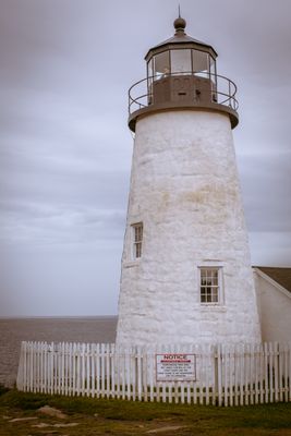
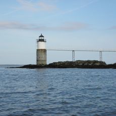
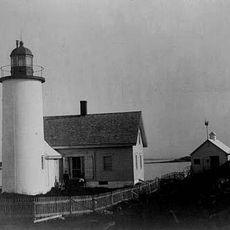
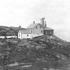
Pemaquid Point Light is a stone tower lighthouse on Maine's rocky Atlantic coast, featuring white walls and a red lantern room at its peak. The structure sits on a peninsula surrounded by walking paths that lead visitors across the coastal terrain toward the water's edge.

The lighthouse was built in 1827 to guide ships through coastal waters safely. Since then it has served as a vital navigational aid for marine traffic and continues to operate today.

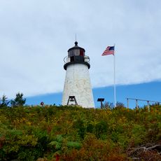
This landmark embodies Maine's fishing heritage and has inspired countless artists and photographers over the decades. People visit to witness and capture the striking contrast between the white tower and the red lantern room against the rocky shore.

The lighthouse can be visited from late spring through autumn, with access to the tower and museum exhibits located at the site. The paths around the grounds are rocky and sometimes steep, so sturdy shoes help visitors move comfortably across the terrain.

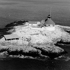
The granite base of the lighthouse merges directly with the natural rock formations of the peninsula. This seamless integration allows the structure to withstand the powerful Atlantic storms and waves across more than two centuries.

The community of curious travelers

AroundUs brings together thousands of curated places, local tips, and hidden gems, enriched daily by 60,000 contributors worldwide.

Start exploring
Location
Inception
1827
Height
11.5 m
Made from material
stone
GPS coordinates
43.83667,-69.50583
Latest update
December 6, 2025 16:02
Nature sites and historic places in Maine

Maine offers coastal areas, forest landscapes and many historic sites. The region extends from the Atlantic Ocean to wooded mountains inland. Visitors find state parks like Baxter and Acadia, which provide opportunities for hiking and observing wildlife. The coast is lined with lighthouses,...

Around this place
Coastal Maine Botanical Gardens
United States of America

Coastal Maine Botanical Gardens

13.2 km
The Cuckolds Light
United States of America

The Cuckolds Light

13.2 km
Fort William Henry
United States of America

Fort William Henry

4.8 km
Burnt Island Light
United States of America

Burnt Island Light

10.9 km
Monhegan Island Light
United States of America

Monhegan Island Light

17.2 km
Pemaquid Archeological Site
United States of America

Pemaquid Archeological Site

4.8 km
Project Puffin
United States of America

Project Puffin

10.3 km
Ram Island Light
United States of America

Ram Island Light

8.3 km
Hendricks Head Light
United States of America

Hendricks Head Light

14.9 km
Bosarge Family Education Center
United States of America

Bosarge Family Education Center

13.2 km
Franklin Island Light
United States of America

Franklin Island Light

12.2 km
Pythian Opera House
United States of America

Pythian Opera House

9.9 km
Manana Island Sound Signal Station
United States of America

Manana Island Sound Signal Station

16.5 km
Arch Bridge
United States of America

Arch Bridge

14 km
Monhegan Island Plantation
United States of America

Monhegan Island Plantation

17.1 km
Sproul Homestead
United States of America

Sproul Homestead

8.8 km
Auld-McCobb House
United States of America

Auld-McCobb House

9.9 km
The Influence
United States of America

The Influence

16.9 km
Boothbay Harbor Memorial Library
United States of America

Boothbay Harbor Memorial Library

10 km
Stephen Parsons House
United States of America

Stephen Parsons House

16.7 km
Walpole Meetinghouse
United States of America

Walpole Meetinghouse

16.8 km
Thompson Icehouse
United States of America

Thompson Icehouse

6.4 km
Knight-Corey House
United States of America

Knight-Corey House

11.3 km
Emily Means House
United States of America

Emily Means House

3.8 km
Cottage on King's Row
United States of America

Cottage on King's Row

12.5 km
Franklin Island National Wildlife Refuge
United States of America

Franklin Island National Wildlife Refuge

12.2 km
Pemaquid Beach
United States of America

Pemaquid Beach

4 km
Southport Bridge
United States of America

Southport Bridge

11.9 km
Show the full map
Reviews
Share your experience

No review yet

Discussions
Start a discussion...

No discussion yet

« Pemaquid Point Light - Maritime navigation beacon in Lincoln County, Maine » is provided by Around Us (aroundus.com). Images and texts are derived from Wikimedia project under a Creative Commons license. You are allowed to copy, distribute, and modify copies of this page, under the conditions set by the license, as long as this note is clearly visible.

Discover hidden gems everywhere you go!

From secret cafés to breathtaking viewpoints, skip the crowded tourist spots and find places that match your style. Our app makes it easy with voice search, smart filtering, route optimization, and insider tips from travelers worldwide. Download now for the complete mobile experience.

Around Us App Screenshot

A unique approach to discovering new places

Le Figaro

All the places worth exploring

France Info

A tailor-made excursion in just a few clicks

20 Minutes

Around Us
Travel Guide & Maps
Download

Send to your phone

QR Code
1

Open the camera app on your mobile.

2

Point at the QR code with your camera. A notification will appear.

3

Tap the notification to open the link.