Enable Location

We need your location to show you interesting places around you

Discover nearby places

Find interesting locations and hidden gems around you

Precise directions

Get accurate directions and distances to places

Your location is never shared with other users. It's only used when you tap the location button.

Franklin Island Light

Log in to your account

Start exploring — it's free

Trusted by 63,006 travelers worldwide

Continue with Google
Continue with Apple
or

We will send you a code to connect

By continuing, you accept our Terms and Conditions and our Privacy Policy

Check your inbox

We've sent a pincode in your inbox. Please enter the code below.

Franklin Island Light
Discussion Reviews 1 Photos
1.5k Popularity

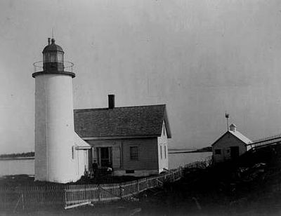
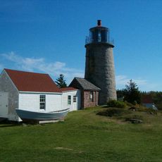
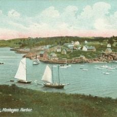
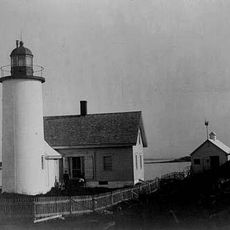
Franklin Island Light, Lighthouse in Muscongus Bay, Maine, US.

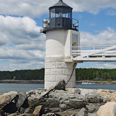
Franklin Island Light is a brick tower standing at the entrance to Muscongus Bay in Maine, serving as a navigation marker for vessels in the area. The structure rises from the water and provides a visual reference point for boats traveling through these waters.

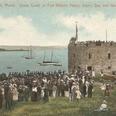
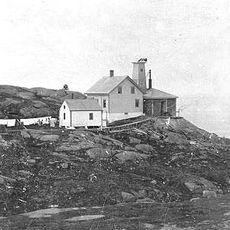
The lighthouse was built in 1805 after Congress authorized funds to improve navigation safety in this region. Its construction was a response to the hazards posed by the rocks surrounding the island to passing ships.

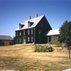
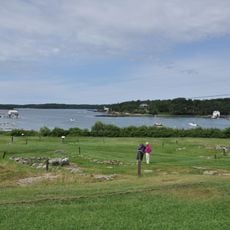
The lighthouse takes its name from the island where it stands, a location that has served as a crucial reference point for maritime navigation along this coast. Visitors sailing past recognize this structure as part of the maritime infrastructure that shaped Maine's seafaring traditions.

The island is not open to the public from April through July, as it functions as a protected wildlife area during nesting season. Visitors should respect this closure to avoid disturbing the local bird populations.

The site also functions as an important bird sanctuary where seabirds come to nest and breed in significant numbers. This dual role as both a navigation aid and a protected wildlife area makes it a distinctive location along the coast.

The community of curious travelers

AroundUs brings together thousands of curated places, local tips, and hidden gems, enriched daily by 60,000 contributors worldwide.

Start exploring
Location
Inception
1805
Height
14 m
GPS coordinates
43.89206,-69.37461
Latest update
December 14, 2025 14:20
Around this place
Olson House
United States of America

Olson House

13.1 km
Pemaquid Point Light
United States of America

Pemaquid Point Light

12.2 km
Whaleback Shell Midden
United States of America

Whaleback Shell Midden

20 km
Marshall Point Light
United States of America

Marshall Point Light

9.5 km
Tenants Harbor Light
United States of America

Tenants Harbor Light

17 km
Fort William Henry
United States of America

Fort William Henry

12.2 km
Monhegan Island Light
United States of America

Monhegan Island Light

14.9 km
Pemaquid Archeological Site
United States of America

Pemaquid Archeological Site

11.9 km
Project Puffin
United States of America

Project Puffin

3.5 km
Perkins Homestead
United States of America

Perkins Homestead

19.3 km
Manana Island Sound Signal Station
United States of America

Manana Island Sound Signal Station

14.8 km
Mosquito Island House
United States of America

Mosquito Island House

12.6 km
Arch Bridge
United States of America

Arch Bridge

13.4 km
Monhegan Island Plantation
United States of America

Monhegan Island Plantation

15.1 km
Chapman-Hall House
United States of America

Chapman-Hall House

20 km
Sproul Homestead
United States of America

Sproul Homestead

14.4 km
The Influence
United States of America

The Influence

14.9 km
Matthew Cottrill House
United States of America

Matthew Cottrill House

20.1 km
Walpole Meetinghouse
United States of America

Walpole Meetinghouse

16.9 km
Thompson Icehouse
United States of America

Thompson Icehouse

15 km
Daniel Weston Homestead
United States of America

Daniel Weston Homestead

12.9 km
Huston House
United States of America

Huston House

18.7 km
Emily Means House
United States of America

Emily Means House

14.8 km
Stephen Coffin House
United States of America

Stephen Coffin House

20.1 km
Cottage on King's Row
United States of America

Cottage on King's Row

9.2 km
Franklin Island National Wildlife Refuge
United States of America

Franklin Island National Wildlife Refuge

124 m
Lincoln County Community Theater
United States of America

Lincoln County Community Theater

20.1 km
Damariscotta Oyster Shell Heaps
United States of America

Damariscotta Oyster Shell Heaps

20 km
Show the full map
Reviews
Share your experience

No review yet

Discussions
Start a discussion...

No discussion yet

« Franklin Island Light - Lighthouse in Muscongus Bay, Maine, US » is provided by Around Us (aroundus.com). Images and texts are derived from Wikimedia project under a Creative Commons license. You are allowed to copy, distribute, and modify copies of this page, under the conditions set by the license, as long as this note is clearly visible.

Discover hidden gems everywhere you go!

From secret cafés to breathtaking viewpoints, skip the crowded tourist spots and find places that match your style. Our app makes it easy with voice search, smart filtering, route optimization, and insider tips from travelers worldwide. Download now for the complete mobile experience.

Around Us App Screenshot

A unique approach to discovering new places

Le Figaro

All the places worth exploring

France Info

A tailor-made excursion in just a few clicks

20 Minutes

Around Us
Travel Guide & Maps
Download

Send to your phone

QR Code
1

Open the camera app on your mobile.

2

Point at the QR code with your camera. A notification will appear.

3

Tap the notification to open the link.