Enable Location

We need your location to show you interesting places around you

Discover nearby places

Find interesting locations and hidden gems around you

Precise directions

Get accurate directions and distances to places

Your location is never shared with other users. It's only used when you tap the location button.

Cedar Island National Wildlife Refuge

Log in to your account

Start exploring — it's free

Trusted by 62,056 travelers worldwide

Continue with Google
Continue with Apple
or

We will send you a code to connect

By continuing, you accept our Terms and Conditions and our Privacy Policy

Check your inbox

We've sent a pincode in your inbox. Please enter the code below.

Cedar Island National Wildlife Refuge

Cedar Island National Wildlife Refuge, National wildlife refuge in Carteret County, North Carolina.

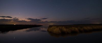
Cedar Island National Wildlife Refuge is a protected area in North Carolina that encompasses salt marshes, tidal flats, and upland areas serving as habitat for numerous bird species. The landscape is shaped by water channels, seasonal flooding, and marsh vegetation that create distinct ecological zones throughout the refuge.

The refuge was established in 1964 as a protected sanctuary for migratory birds moving along the Atlantic coast. Before that, the land served hunting and fishing interests, but designation as a wildlife refuge changed its purpose to conservation.

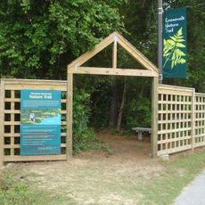
The refuge serves as a place where visitors can directly experience coastal wildlife and understand how birds depend on salt marsh environments. Walking through the area, you notice how the birds move freely across the water and reeds throughout the day.

Two public boat ramps with parking make it easy for visitors to launch boats for fishing and watching wildlife throughout the protected waters. The best way to explore the interior is by water, either with your own boat or by joining organized tours that navigate the shallow channels.

The refuge holds North Carolina's largest population of eastern black rails, secretive birds that hide in the brackish marshes and are rarely spotted by visitors. Despite their abundance here, these small dark birds remain one of the hardest species to actually see during a visit.

The community of curious travelers

AroundUs brings together thousands of curated places, local tips, and hidden gems, enriched daily by 60,000 contributors worldwide.

Start exploring
Location
Inception
1964
GPS coordinates
34.95139,-76.28139
Latest update
December 13, 2025 12:23
Around this place
Fort Macon State Park
United States of America

Fort Macon State Park

46.9 km
Cape Lookout Lighthouse
United States of America

Cape Lookout Lighthouse

42.8 km
Cape Lookout National Seashore
United States of America

Cape Lookout National Seashore

14.5 km
Ocracoke Light
United States of America

Ocracoke Light

32.1 km
North Carolina Maritime Museum
United States of America

North Carolina Maritime Museum

43.7 km
United States of America

Neusiok Trail

47.9 km
Theodore Roosevelt State Natural Area
United States of America

Theodore Roosevelt State Natural Area

57.8 km
Cape Lookout Village Historic District
United States of America

Cape Lookout Village Historic District

44.7 km
China Grove
United States of America

China Grove

44.2 km
Cape Lookout Coast Guard Station
United States of America

Cape Lookout Coast Guard Station

45.3 km
Lake Mattamuskeet Pump Station
United States of America

Lake Mattamuskeet Pump Station

56.5 km
Beaufort Historic District
United States of America

Beaufort Historic District

43.8 km
Morehead City Historic District
United States of America

Morehead City Historic District

47 km
Jacob Henry House
United States of America

Jacob Henry House

43.8 km
Gibbs House
United States of America

Gibbs House

43.5 km
Morehead City Municipal Building
United States of America

Morehead City Municipal Building

47.1 km
Carteret County Home
United States of America

Carteret County Home

41.8 km
George V. Credle House and Cemetery
United States of America

George V. Credle House and Cemetery

56.5 km
Core Sound Waterfowl Museum
United States of America

Core Sound Waterfowl Museum

37.1 km
Cape Lookout Visitor's Center
United States of America

Cape Lookout Visitor's Center

37.2 km
Keepers' Quarters Museum
United States of America

Keepers' Quarters Museum

42.8 km
Beaufort Historic Site
United States of America

Beaufort Historic Site

43.7 km
Havelock Tourist & Event Center
United States of America

Havelock Tourist & Event Center

59.3 km
Harkers Island Visitor Center
United States of America

Harkers Island Visitor Center

37.1 km
History Museum of Carteret County
United States of America

History Museum of Carteret County

47.3 km
Cape Lookout Lighthouse
United States of America

Cape Lookout Lighthouse

42.8 km
Fort Macon
United States of America

Fort Macon

46.2 km
Light Station Visitor Center
United States of America

Light Station Visitor Center

42.6 km
Show the full map
« Cedar Island National Wildlife Refuge - National wildlife refuge in Carteret County, North Carolina » is provided by Around Us (aroundus.com). Images and texts are derived from Wikimedia project under a Creative Commons license. You are allowed to copy, distribute, and modify copies of this page, under the conditions set by the license, as long as this note is clearly visible.

Discover hidden gems everywhere you go!

From secret cafés to breathtaking viewpoints, skip the crowded tourist spots and find places that match your style. Our app makes it easy with voice search, smart filtering, route optimization, and insider tips from travelers worldwide. Download now for the complete mobile experience.

Around Us App Screenshot

A unique approach to discovering new places

Le Figaro

All the places worth exploring

France Info

A tailor-made excursion in just a few clicks

20 Minutes

Around Us
Travel Guide & Maps
Download

Send to your phone

QR Code
1

Open the camera app on your mobile.

2

Point at the QR code with your camera. A notification will appear.

3

Tap the notification to open the link.