Enable Location

We need your location to show you interesting places around you

Discover nearby places

Find interesting locations and hidden gems around you

Precise directions

Get accurate directions and distances to places

Your location is never shared with other users. It's only used when you tap the location button.

Cedar Key Light

Log in to your account

Start exploring — it's free

Trusted by 62,557 travelers worldwide

Continue with Google
Continue with Apple
or

We will send you a code to connect

By continuing, you accept our Terms and Conditions and our Privacy Policy

Check your inbox

We've sent a pincode in your inbox. Please enter the code below.

Cedar Key Light

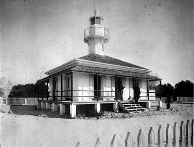
Cedar Key Light, Integral lighthouse on Seahorse Key, Florida, US.

Cedar Key Light is a lighthouse on Seahorse Key in Florida that rises about 23 meters above the water. It stands within the Cedar Keys National Wildlife Refuge and now serves as a research facility for the University of Florida.

The tower was built in 1854 and received a Fresnel lens that was crucial for ship navigation along the Gulf Coast. In 2019, a replica of the historic lens was installed, restoring the tower's ability to shine.

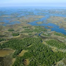
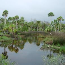
The tower marks the landscape of the wildlife refuge and reflects the maritime importance that shaped this coastal area. Visitors can sense the connection between the structure and the seafaring heritage of the region.

The tower stands on an island within a protected refuge and is not freely accessible to visitors. Expect restrictions since the site operates as a research center today.

The structure guided ships safely past this dangerous coastal area for over 140 years, though it stood dark for a long period in between. The lens replica installation made it one of the few restored lighthouses that actually shines again.

The community of curious travelers

AroundUs brings together thousands of curated places, local tips, and hidden gems, enriched daily by 60,000 contributors worldwide.

Start exploring
Location
Inception
1854
GPS coordinates
29.09648,-83.06528
Latest update
December 12, 2025 09:02
Around this place
Devil's Den
United States of America

Devil's Den

68.2 km
Homosassa Springs Wildlife State Park
United States of America

Homosassa Springs Wildlife State Park

57 km
Crystal River Archaeological State Park
United States of America

Crystal River Archaeological State Park

48.7 km
Chassahowitzka National Wildlife Refuge
United States of America

Chassahowitzka National Wildlife Refuge

59.2 km
Crystal River National Wildlife Refuge
United States of America

Crystal River National Wildlife Refuge

50.9 km
Fanning Springs State Park
United States of America

Fanning Springs State Park

56 km
Lower Suwannee National Wildlife Refuge
United States of America

Lower Suwannee National Wildlife Refuge

24.7 km
Yulee Sugar Mill Ruins State Historic Site
United States of America

Yulee Sugar Mill Ruins State Historic Site

56.7 km
Goethe State Forest
United States of America

Goethe State Forest

49.3 km
Cedar Key Museum State Park
United States of America

Cedar Key Museum State Park

6.6 km
City of Hawkinsville
United States of America

City of Hawkinsville

57.6 km
Coca-Cola Bottling Plant
United States of America

Coca-Cola Bottling Plant

62.7 km
Gilchrist County Courthouse
United States of America

Gilchrist County Courthouse

62.3 km
First Baptist Church
United States of America

First Baptist Church

62.5 km
Old Town Elementary School
United States of America

Old Town Elementary School

55.6 km
Newberry Historic District
United States of America

Newberry Historic District

75.2 km
Dunnellon Boomtown Historic District
United States of America

Dunnellon Boomtown Historic District

58.8 km
Cedar Key Historical Museum
United States of America

Cedar Key Historical Museum

5.4 km
Crystal River Old City Hall
United States of America

Crystal River Old City Hall

51 km
Trenton Church of Christ
United States of America

Trenton Church of Christ

62.2 km
Old Town Methodist Church
United States of America

Old Town Methodist Church

56.9 km
Levy County Courthouse
United States of America

Levy County Courthouse

57.6 km
Crystal River Archaeological State Park
United States of America

Crystal River Archaeological State Park

47.4 km
John A. King House
United States of America

John A. King House

72 km
Citizens Bank
United States of America

Citizens Bank

68.2 km
Archer Historical Society Museum
United States of America

Archer Historical Society Museum

71.5 km
The Museum Cafe
United States of America

The Museum Cafe

56.6 km
Joe H. Anderson Sr. Bridge
United States of America

Joe H. Anderson Sr. Bridge

56.3 km
Show the full map
« Cedar Key Light - Integral lighthouse on Seahorse Key, Florida, US » is provided by Around Us (aroundus.com). Images and texts are derived from Wikimedia project under a Creative Commons license. You are allowed to copy, distribute, and modify copies of this page, under the conditions set by the license, as long as this note is clearly visible.

Discover hidden gems everywhere you go!

From secret cafés to breathtaking viewpoints, skip the crowded tourist spots and find places that match your style. Our app makes it easy with voice search, smart filtering, route optimization, and insider tips from travelers worldwide. Download now for the complete mobile experience.

Around Us App Screenshot

A unique approach to discovering new places

Le Figaro

All the places worth exploring

France Info

A tailor-made excursion in just a few clicks

20 Minutes

Around Us
Travel Guide & Maps
Download

Send to your phone

QR Code
1

Open the camera app on your mobile.

2

Point at the QR code with your camera. A notification will appear.

3

Tap the notification to open the link.