Enable Location

We need your location to show you interesting places around you

Discover nearby places

Find interesting locations and hidden gems around you

Precise directions

Get accurate directions and distances to places

Your location is never shared with other users. It's only used when you tap the location button.

Central Hardin High School

Log in to your account

Start exploring — it's free

Trusted by 65,072 travelers worldwide

Continue with Google
Continue with Apple
or

We will send you a code to connect

By continuing, you accept our Terms and Conditions and our Privacy Policy

Check your inbox

We've sent a pincode in your inbox. Please enter the code below.

Central Hardin High School
Discussion Reviews 1 Photos
3.5k Popularity

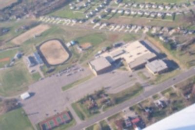
Central Hardin High School, Public high school in Hardin County, United States

Central Hardin High School is a public secondary school in Hardin County, Kentucky, serving students in grades 9 through 12. The campus includes classrooms, science labs, a gymnasium, and outdoor athletic fields used throughout the school year.

The school was founded to provide secondary education to young people across Hardin County and has grown alongside the county over the decades. Expansions to the campus were made over time to keep up with a growing student body.

Friday night football games draw large crowds from across the county, turning the school into a gathering point for the whole community. The school mascot and team colors are a visible part of local identity throughout Hardin County.

The campus is open to visitors during school events such as sports games or performances, but access during regular school hours is limited. If you plan to attend an event, it helps to check in advance, as parking and entry points can vary.

The school's teams compete under the name Bruins, a name that former students carry with them long after graduation. This shared identity connects generations of people who grew up in Hardin County.

The community of curious travelers

AroundUs brings together thousands of curated places, local tips, and hidden gems, enriched daily by 60,000 contributors worldwide.

Start exploring
Location
GPS coordinates
37.67527,-85.90676
Latest update
March 3, 2026 14:01
Around this place
United States Bullion Depository
United States of America

United States Bullion Depository

23.7 km
Abraham Lincoln Birthplace National Historical Park
United States of America

Abraham Lincoln Birthplace National Historical Park

22 km
The Abbey of Our Lady of Gethsemani
United States of America

The Abbey of Our Lady of Gethsemani

33.3 km
General George Patton Museum of Leadership
United States of America

General George Patton Museum of Leadership

25.3 km
Knob Creek Farm
United States of America

Knob Creek Farm

24.7 km
Louisville and Nashville Railroad 152
United States of America

Louisville and Nashville Railroad 152

27.8 km
Statue of Abraham Lincoln
United States of America

Statue of Abraham Lincoln

18.5 km
Fort Duffield
United States of America

Fort Duffield

35.5 km
Louisville and Nashville Combine Car Number 665
United States of America

Louisville and Nashville Combine Car Number 665

27.8 km
United States of America

Knobs State Forest

30.6 km
Brown Pusey House Community Center
United States of America

Brown Pusey House Community Center

4.9 km
Helm Place
United States of America

Helm Place

4.9 km
First Baptist Church
United States of America

First Baptist Church

4.8 km
Benjamin Helm House
United States of America

Benjamin Helm House

4.3 km
William Bush House
United States of America

William Bush House

8.7 km
Christ Episcopal Church
United States of America

Christ Episcopal Church

4.8 km
Larue-Layman House
United States of America

Larue-Layman House

4.8 km
First Presbyterian Church
United States of America

First Presbyterian Church

4.5 km
Embry Chapel Church
United States of America

Embry Chapel Church

4.6 km
Morrison Lodge
United States of America

Morrison Lodge

4.8 km
Elizabethtown Courthouse Square and Commercial District
United States of America

Elizabethtown Courthouse Square and Commercial District

4.7 km
J. Roy Bond House
United States of America

J. Roy Bond House

4.1 km
Kentucky Railway Museum
United States of America

Kentucky Railway Museum

27.7 km
Patton Museum Foundation
United States of America

Patton Museum Foundation

25.3 km
State Theater
United States of America

State Theater

4.6 km
Bonn Theater
United States of America

Bonn Theater

25.6 km
Waybur Theatre
United States of America

Waybur Theatre

24.7 km
Samuel B. Thomas House
United States of America

Samuel B. Thomas House

4.7 km
Show the full map
Reviews
Share your experience

No review yet

Discussions
Start a discussion...

No discussion yet

« Central Hardin High School - Public high school in Hardin County, United States » is provided by Around Us (aroundus.com). Images and texts are derived from Wikimedia project under a Creative Commons license. You are allowed to copy, distribute, and modify copies of this page, under the conditions set by the license, as long as this note is clearly visible.

Discover hidden gems everywhere you go!

From secret cafés to breathtaking viewpoints, skip the crowded tourist spots and find places that match your style. Our app makes it easy with voice search, smart filtering, route optimization, and insider tips from travelers worldwide. Download now for the complete mobile experience.

Around Us App Screenshot

A unique approach to discovering new places

Le Figaro

All the places worth exploring

France Info

A tailor-made excursion in just a few clicks

20 Minutes

Around Us
Travel Guide & Maps
Download

Send to your phone

QR Code
1

Open the camera app on your mobile.

2

Point at the QR code with your camera. A notification will appear.

3

Tap the notification to open the link.