Enable Location

We need your location to show you interesting places around you

Discover nearby places

Find interesting locations and hidden gems around you

Precise directions

Get accurate directions and distances to places

Your location is never shared with other users. It's only used when you tap the location button.

Fort Duffield

Log in to your account

Start exploring — it's free

Trusted by 65,072 travelers worldwide

Continue with Google
Continue with Apple
or

We will send you a code to connect

By continuing, you accept our Terms and Conditions and our Privacy Policy

Check your inbox

We've sent a pincode in your inbox. Please enter the code below.

Discussion Reviews 1 Photos
3.9k Popularity

Fort Duffield, Civil War fortification in West Point, Kentucky.

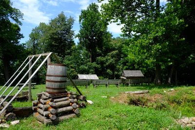
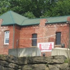
Fort Duffield is an earthwork fortification from the Civil War era built on Pearman Hill in West Point, Kentucky. The site consists of earthen walls, ditches, and defensive positions that are still clearly visible across the hilltop.

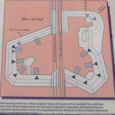
The fort was built in 1861 by the 9th Michigan Infantry after Confederate forces took control of Columbus, making it the first Union fortification established in Kentucky during the Civil War. It was intended to hold a key position along the Ohio River valley.

A small cemetery on the grounds holds soldiers who died during the Civil War, and visitors can walk among the grave markers to read the names of those who served here. The cemetery gives the site a quiet personal dimension that goes beyond military history.

The site is free to enter and has trails for walking and mountain biking, along with picnic areas on the hillside. Sturdy footwear is a good idea since some sections of the trail are uneven or steep.

Fort Duffield is considered the largest surviving Civil War earthwork in Kentucky, and its walls have held their shape for over 150 years without major restoration. The fort was never directly attacked, which is likely why the original structure has remained so intact.

The community of curious travelers

AroundUs brings together thousands of curated places, local tips, and hidden gems, enriched daily by 60,000 contributors worldwide.

Start exploring
Location
GPS coordinates
37.99306,-85.94194
Latest update
March 3, 2026 14:04
Around this place
United States Bullion Depository
United States of America

United States Bullion Depository

12.4 km
Churchill Downs
United States of America

Churchill Downs

27.8 km
General George Patton Museum of Leadership
United States of America

General George Patton Museum of Leadership

11.1 km
Storm Chaser
United States of America

Storm Chaser

28.1 km
Confederate Monument in Louisville
United States of America

Confederate Monument in Louisville

20 km
Doe Run Inn
United States of America

Doe Run Inn

16.2 km
Little Loomhouse
United States of America

Little Loomhouse

23.7 km
Matthew E. Welsh Bridge
United States of America

Matthew E. Welsh Bridge

22.5 km
Louisville Falls Fountain
United States of America

Louisville Falls Fountain

27.9 km
Riverside, The Farnsley-Moremen Landing
United States of America

Riverside, The Farnsley-Moremen Landing

12.3 km
United States of America

Knobs State Forest

26.4 km
Kintner-Withers House
United States of America

Kintner-Withers House

10.5 km
Fort DeWolf
United States of America

Fort DeWolf

19.7 km
Gabriel Farnsley House
United States of America

Gabriel Farnsley House

22 km
Bank of the Commonwealth
United States of America

Bank of the Commonwealth

19.7 km
Meade County Jail
United States of America

Meade County Jail

19.9 km
Epworth Methodist Evangelical Church
United States of America

Epworth Methodist Evangelical Church

26.9 km
Brandenburg Methodist Episcopal Church
United States of America

Brandenburg Methodist Episcopal Church

20 km
South Louisville Reformed Church
United States of America

South Louisville Reformed Church

24.9 km
Riverside, the Farnsley-Moremen Landing
United States of America

Riverside, the Farnsley-Moremen Landing

12.2 km
Immanuel Chapel Protestant Episcopal Church
United States of America

Immanuel Chapel Protestant Episcopal Church

27.2 km
Edward Yeakel House
United States of America

Edward Yeakel House

19.9 km
Brandenburg Commercial District
United States of America

Brandenburg Commercial District

20 km
Solomon Neill Brooks House
United States of America

Solomon Neill Brooks House

23.9 km
Jones-Willis House
United States of America

Jones-Willis House

20 km
Patton Museum Foundation
United States of America

Patton Museum Foundation

11.1 km
Waybur Theatre
United States of America

Waybur Theatre

11 km
Doe Run Creek Historic District
United States of America

Doe Run Creek Historic District

16.8 km
Show the full map
Reviews
Share your experience

No review yet

Discussions
Start a discussion...

No discussion yet

« Fort Duffield - Civil War fortification in West Point, Kentucky » is provided by Around Us (aroundus.com). Images and texts are derived from Wikimedia project under a Creative Commons license. You are allowed to copy, distribute, and modify copies of this page, under the conditions set by the license, as long as this note is clearly visible.

Discover hidden gems everywhere you go!

From secret cafés to breathtaking viewpoints, skip the crowded tourist spots and find places that match your style. Our app makes it easy with voice search, smart filtering, route optimization, and insider tips from travelers worldwide. Download now for the complete mobile experience.

Around Us App Screenshot

A unique approach to discovering new places

Le Figaro

All the places worth exploring

France Info

A tailor-made excursion in just a few clicks

20 Minutes

Around Us
Travel Guide & Maps
Download

Send to your phone

QR Code
1

Open the camera app on your mobile.

2

Point at the QR code with your camera. A notification will appear.

3

Tap the notification to open the link.