Enable Location

We need your location to show you interesting places around you

Discover nearby places

Find interesting locations and hidden gems around you

Precise directions

Get accurate directions and distances to places

Your location is never shared with other users. It's only used when you tap the location button.

Cheboygan Bascule Bridge

Log in to your account

Start exploring — it's free

Trusted by 61,910 travelers worldwide

Continue with Google
Continue with Apple
or

We will send you a code to connect

By continuing, you accept our Terms and Conditions and our Privacy Policy

Check your inbox

We've sent a pincode in your inbox. Please enter the code below.

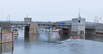
Cheboygan Bascule Bridge, Bascule bridge in Cheboygan, United States.

The Cheboygan Bascule Bridge is a lift bridge featuring three steel girder spans, with the central lifting section spanning about 70 feet (21 meters) across the Cheboygan River. It carries traffic along US Highway 23 while allowing boat passage underneath.

It was built in 1940 to replace an older swing bridge that dated to 1877. This was the final bascule bridge constructed in Michigan before World War II began.

The bridge serves as a familiar landmark for locals and visitors, showing how the town connects its land and water communities. You see people stop and watch whenever it lifts to let boats pass through.

Warning lights and gates signal drivers and pedestrians when the bridge is about to lift. It helps to notice these signals if you are in the area, so you can plan to cross before the lift happens or wait accordingly.

Its construction required complex engineering to handle both highway traffic on US Route 23 and river vessel navigation at the same time. This dual purpose made the design notably challenging for when it was built.

The community of curious travelers

AroundUs brings together thousands of curated places, local tips, and hidden gems, enriched daily by 60,000 contributors worldwide.

Start exploring
Location
Official opening
December 1940
GPS coordinates
45.64590,-84.47280
Latest update
December 14, 2025 14:44
Around this place
Fort de Buade
United States of America

Fort de Buade

14.8 km
Biddle House
United States of America

Biddle House

25.3 km
Round Island Light
United States of America

Round Island Light

24.1 km
Aloha State Park
United States of America

Aloha State Park

14.1 km
University of Michigan Biological Station
United States of America

University of Michigan Biological Station

17.5 km
Poe Reef Light
United States of America

Poe Reef Light

10.2 km
Historic Mill Creek State Park
United States of America

Historic Mill Creek State Park

18.9 km
Cheboygan Crib Light
United States of America

Cheboygan Crib Light

1.4 km
Fourteen Foot Shoal Light
United States of America

Fourteen Foot Shoal Light

4.8 km
Cheboygan State Park
United States of America

Cheboygan State Park

5 km
Robert Stuart House
United States of America

Robert Stuart House

25.4 km
Round Island Passage Light
United States of America

Round Island Passage Light

24.6 km
Bois Blanc Light
United States of America

Bois Blanc Light

18.8 km
Mama Mia's Pizza
United States of America

Mama Mia's Pizza

24.9 km
Mackinac Art Museum
United States of America

Mackinac Art Museum

25.4 km
Opera House
United States of America

Opera House

321 m
Newton–Allaire House
United States of America

Newton–Allaire House

478 m
Forrest J. Stimpson House
United States of America

Forrest J. Stimpson House

25.2 km
Island House
United States of America

Island House

25.3 km
Old Cheboygan County Courthouse
United States of America

Old Cheboygan County Courthouse

1 km
Historic Mill Creek Discovery Park
United States of America

Historic Mill Creek Discovery Park

19 km
The Wacky Taxidermy and Miniatures Museum
United States of America

The Wacky Taxidermy and Miniatures Museum

24.8 km
Mackinaw Bridge Museum
United States of America

Mackinaw Bridge Museum

25 km
Kingston Theater
United States of America

Kingston Theater

185 m
Michigan State Ferry System Historical Marker
United States of America

Michigan State Ferry System Historical Marker

24.6 km
Mackinaw City Historical Marker
United States of America

Mackinaw City Historical Marker

24.7 km
Market Street Historical Marker
United States of America

Market Street Historical Marker

25.4 km
Mackinaw City Municipal Building
United States of America

Mackinaw City Municipal Building

24.8 km
Show the full map
« Cheboygan Bascule Bridge - Bascule bridge in Cheboygan, United States » is provided by Around Us (aroundus.com). Images and texts are derived from Wikimedia project under a Creative Commons license. You are allowed to copy, distribute, and modify copies of this page, under the conditions set by the license, as long as this note is clearly visible.

Discover hidden gems everywhere you go!

From secret cafés to breathtaking viewpoints, skip the crowded tourist spots and find places that match your style. Our app makes it easy with voice search, smart filtering, route optimization, and insider tips from travelers worldwide. Download now for the complete mobile experience.

Around Us App Screenshot

A unique approach to discovering new places

Le Figaro

All the places worth exploring

France Info

A tailor-made excursion in just a few clicks

20 Minutes

Around Us
Travel Guide & Maps
Download

Send to your phone

QR Code
1

Open the camera app on your mobile.

2

Point at the QR code with your camera. A notification will appear.

3

Tap the notification to open the link.