Enable Location

We need your location to show you interesting places around you

Discover nearby places

Find interesting locations and hidden gems around you

Precise directions

Get accurate directions and distances to places

Your location is never shared with other users. It's only used when you tap the location button.

Log in to your account

Start exploring — it's free

Trusted by 61,831 travelers worldwide

Continue with Google
Continue with Apple
or

We will send you a code to connect

By continuing, you accept our Terms and Conditions and our Privacy Policy

Check your inbox

We've sent a pincode in your inbox. Please enter the code below.

Clarks Ferry Bridge

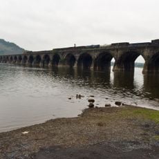
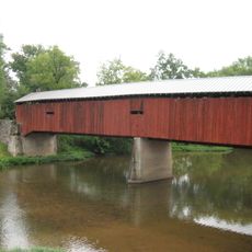
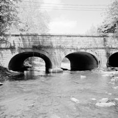
Clarks Ferry Bridge, Road bridge across Susquehanna River in Dauphin County, Pennsylvania.

Description

Clarks Ferry Bridge is a road crossing that carries US Routes 22 and 322 over the Susquehanna River near Duncannon. It spans across the water with four lanes and serves as a main passage for vehicles traveling between the two riverbanks in Dauphin County.

History

The first bridge at this crossing opened in 1828 and was built from over a million board feet of white pine lumber. Before this structure, the site served as a ferry operation starting in 1788 when Daniel Clark established his service to help travelers cross the river.

Culture

The crossing here has long served as a passage point where people moved between the river's banks, shaping settlement patterns in the region. Today it remains a practical link that connects communities on both sides of the water.

Practical

The crossing is open year-round to traffic, though volume can be heavy during daytime hours. Upcoming maintenance work over the next few years may cause occasional delays, so plan accordingly if you are traveling through this area.

Did you know?

The site connects two major recreation trails, as both the Appalachian Trail and BicyclePA Route J pass through this crossing. This makes it a notable meeting point where long-distance hikers and cyclists converge while traveling across the Susquehanna.

Location
GPS coordinates
40.39970,-77.00910
Latest update
December 12, 2025 17:49

AroundUs brings together thousands of curated places, local tips, and hidden gems, enriched daily by 60,000 contributors worldwide. Discover all places nearby (Pennsylvania).

Around this place
Pennsylvania Governor's Residence
United States of America

Pennsylvania Governor's Residence

16.5 km
Rockville Bridge
United States of America

Rockville Bridge

11.2 km
Little Buffalo State Park
United States of America

Little Buffalo State Park

15.1 km
Boyd Big Tree Preserve Conservation Area
United States of America

Boyd Big Tree Preserve Conservation Area

13.7 km
Zembo Shrine Building
United States of America

Zembo Shrine Building

15.3 km
Joseph E. Ibberson Conservation Area
United States of America

Joseph E. Ibberson Conservation Area

13.4 km
Wildwood Park
United States of America

Wildwood Park

14.1 km
Kesher Israel Congregation
United States of America

Kesher Israel Congregation

15.7 km
Archibald McAllister House
United States of America

Archibald McAllister House

10.5 km
Dauphin County Veteran's Memorial Obelisk
United States of America

Dauphin County Veteran's Memorial Obelisk

15.2 km
Clemson Island Prehistoric District
United States of America

Clemson Island Prehistoric District

9 km
Dellville Covered Bridge
United States of America

Dellville Covered Bridge

10 km
State Game Lands Number 256
United States of America

State Game Lands Number 256

10.5 km
Newport Historic District
United States of America

Newport Historic District

13.6 km
Perry County Courthouse
United States of America

Perry County Courthouse

15.3 km
Sheffield Apartments
United States of America

Sheffield Apartments

16.7 km
Wesley Union African Methodist Episcopal Zion Church
United States of America

Wesley Union African Methodist Episcopal Zion Church

16.3 km
Fort Hunter Historic District
United States of America

Fort Hunter Historic District

10.7 km
Simon Cameron School
United States of America

Simon Cameron School

16.9 km
Bridge in Newport Borough
United States of America

Bridge in Newport Borough

13.2 km
William Donaldson House
United States of America

William Donaldson House

16.6 km
John Ayres House
United States of America

John Ayres House

5.2 km
George Trimble House
United States of America

George Trimble House

14.9 km
Fleisher Covered Bridge
United States of America

Fleisher Covered Bridge

16.1 km
Bridge in Reed Township
United States of America

Bridge in Reed Township

2.4 km
Little Buffalo Historic District
United States of America

Little Buffalo Historic District

15 km
Marysville Bridge
United States of America

Marysville Bridge

8.1 km
Halifax, Pennsylvania
United States of America

Halifax, Pennsylvania

10.1 km
Show the full map
« Clarks Ferry Bridge - Road bridge across Susquehanna River in Dauphin County, Pennsylvania » is provided by Around Us (aroundus.com). Images and texts are derived from Wikimedia project under a Creative Commons license. You are allowed to copy, distribute, and modify copies of this page, under the conditions set by the license, as long as this note is clearly visible.

Discover hidden gems everywhere you go!

From secret cafés to breathtaking viewpoints, skip the crowded tourist spots and find places that match your style. Our app makes it easy with voice search, smart filtering, route optimization, and insider tips from travelers worldwide. Download now for the complete mobile experience.

Around Us App Screenshot

A unique approach to discovering new places

Le Figaro

All the places worth exploring

France Info

A tailor-made excursion in just a few clicks

20 Minutes

Around Us
Travel Guide & Maps
Download

Send to your phone

QR Code
1

Open the camera app on your mobile.

2

Point at the QR code with your camera. A notification will appear.

3

Tap the notification to open the link.