Colville Covered Bridge

Log in to your account

AroundUs is a community-driven map of interesting places, built by curious explorers like you. It grows with every review, story, and photo you share.
Connect to save your favorite spots, contribute locations, and create personalized routes.
Continue with Google
Continue with Apple
Continue with X
Continue with Facebook
Continue with email
By continuing, you accept our Terms and Conditions and our Privacy Policy
Create an account
Add to collection
Map
Suggest a change
Share

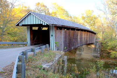
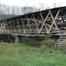
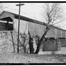
Colville Covered Bridge, Covered bridge in Bourbon County, Kentucky, US.

Colville Covered Bridge is a timber structure crossing Hinkston Creek that employs a Burr truss design typical of Kentucky's 19th-century bridge construction. Its wooden framework includes interlocking supports and panel systems characteristic of this engineering approach.

Built in 1877 by Jacob Bower of the Maysville Bridge Company, the structure survived into modern times as one of Kentucky's few remaining covered bridges. It faced severe damage from flooding in 1997 but was restored a few years later using both original salvaged components and new timber.

The bridge connects two rural communities and remains an active part of daily travel for local residents and farmers. It represents a tangible link to 19th-century engineering practices that shaped transportation across the region.

The bridge remains open to vehicle traffic and can be crossed on foot, though drivers should exercise caution on the narrow wooden deck. Finding the site requires navigation through rural roads with minimal signage, so directions or a map app beforehand helps.

The bridge earned recognition for its resilience after severe 1997 flooding destroyed its original timber structure entirely. Its reconstruction cleverly blended salvaged pieces from the collapsed structure with new materials to maintain historical authenticity.

Location: Bourbon County

Inception: 1877

Architectural style: Burr Truss

GPS coordinates: 38.32444,-84.20333

Latest update: December 14, 2025 14:44

Photos
Around this place
Kentucky Horse Park
United States of America

Kentucky Horse Park

33.5 km
Cane Ridge
United States of America

Cane Ridge

13.2 km
Blue Licks Battlefield State Park
United States of America

Blue Licks Battlefield State Park

21.6 km
United States of America

Mount Horeb Earthworks Complex

29.4 km
Confederate Monument in Cynthiana
United States of America

Confederate Monument in Cynthiana

10.3 km
The Grange
United States of America

The Grange

7.9 km
Johnson Creek Covered Bridge
United States of America

Johnson Creek Covered Bridge

26.3 km
Mound Hill Archaeological Site
United States of America

Mound Hill Archaeological Site

26 km
Forest Retreat
United States of America

Forest Retreat

12.5 km
United States of America

Bourbon County Courthouse

13 km
Church of the Advent, Episcopal
United States of America

Church of the Advent, Episcopal

11.2 km
Shropshire House
United States of America

Shropshire House

33.3 km
Thomas Metcalf House
United States of America

Thomas Metcalf House

21.4 km
Walker Buckner House
United States of America

Walker Buckner House

15.2 km
Georgetown College Historic Buildings
United States of America

Georgetown College Historic Buildings

33.4 km
Harrison County Courthouse
United States of America

Harrison County Courthouse

10.9 km
Snow Hill
United States of America

Snow Hill

18.5 km
Stone Barn on Brushy Creek
United States of America

Stone Barn on Brushy Creek

11.9 km
Paris Courthouse Square Historic District
United States of America

Paris Courthouse Square Historic District

13.1 km
Georgetown East Main Street Residential District
United States of America

Georgetown East Main Street Residential District

33.2 km
Johnston-Jacobs House
United States of America

Johnston-Jacobs House

33.5 km
Robertson County Courthouse
United States of America

Robertson County Courthouse

27.3 km
William Mathers House
United States of America

William Mathers House

14 km
Cynthiana Commercial District
United States of America

Cynthiana Commercial District

19.6 km
Erasmus Riggs House
United States of America

Erasmus Riggs House

14.6 km
Thomas A. Dorsey Farmhouse
United States of America

Thomas A. Dorsey Farmhouse

15.8 km
McKee-Vimont Row Houses
United States of America

McKee-Vimont Row Houses

5.4 km
Covered Bridge over the South Fork of Licking River
United States of America

Covered Bridge over the South Fork of Licking River

10.9 km
Show the full map
Reviews

Visited this place? Tap the stars to rate it and share your experience / photos with the community! Try now! You can cancel it anytime.

« Colville Covered Bridge - Covered bridge in Bourbon County, Kentucky, US » is provided by Around Us (aroundus.com). Images and texts are derived from Wikimedia project under a Creative Commons license. You are allowed to copy, distribute, and modify copies of this page, under the conditions set by the license, as long as this note is clearly visible.

Discover hidden gems everywhere you go!

From secret cafés to breathtaking viewpoints, skip the crowded tourist spots and find places that match your style. Our app makes it easy with voice search, smart filtering, route optimization, and insider tips from travelers worldwide. Download now for the complete mobile experience.

Around Us App Screenshot

A unique approach to discovering new places

Le Figaro

All the places worth exploring

France Info

A tailor-made excursion in just a few clicks

20 Minutes