Chest opened
+${chestReward.xp} XP
Explorer
NOUVEAU ×${chestReward.collectible.quantity}
tapez pour fermer
Chest locked

Open chests in the app

Around Us is built for your phone — chests unlock when you walk, explore and capture nearby places.

Enable Location

We need your location to show you interesting places around you

Discover nearby places

Find interesting locations and hidden gems around you

Precise directions

Get accurate directions and distances to places

Your location is never shared with other users. It's only used when you tap the location button.

Log in to your account

Start exploring — it's free

Trusted by 72,937 travelers worldwide

Continue with Google
Continue with Apple
or

We will send you a code to connect

By continuing, you accept our Terms and Conditions and our Privacy Policy

Check your inbox

We've sent a pincode in your inbox. Please enter the code below.

Crowley's Ridge
Discussion Reviews Photo
28.5k Popularity

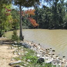
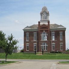
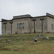
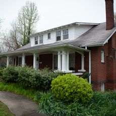
Crowley's Ridge, Geological ridge in Cross County, Arkansas, United States.

Crowley's Ridge is a geological ridge that runs across eastern Arkansas and rises above the Mississippi Alluvial Plain. The formation stretches across the region with varying widths and defines the landscape of Cross County.

The ridge takes its name from Benjamin Crowley, who established the first settlement near present-day Paragould around 1820. His name became the permanent designation for this natural formation.

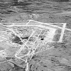
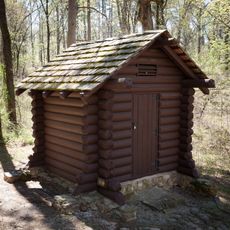
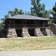
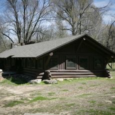
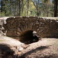
The Civilian Conservation Corps constructed native log structures and stone buildings in the 1930s, creating recreational spaces throughout Crowley's Ridge State Park.

The area offers hiking trails with varying difficulty levels suited to different fitness levels and abilities. Visitors should expect uneven terrain and bring appropriate footwear and water.

The soil contains loess deposited by wind to significant depths, creating conditions where tree species typical of the western Appalachian Mountains can thrive. This unusual soil composition allows forest types that would not normally occur in this part of the South.

The community of curious travelers

AroundUs brings together thousands of curated places, local tips, and hidden gems, enriched daily by 60,000 contributors worldwide.

Start exploring
Location
Elevation above the sea
156 m
GPS coordinates
36.14200,-90.57500
Latest update
December 20, 2025 12:30
Around this place
Marine Corps Air Facility Walnut Ridge
United States of America

Marine Corps Air Facility Walnut Ridge

31.5 km
Crowley's Ridge State Park
United States of America

Crowley's Ridge State Park

13.4 km
Paragould meteorite
United States of America

Paragould meteorite

16.8 km
Lake Frierson State Park
United States of America

Lake Frierson State Park

22.7 km
George Ray's Dragstrip
United States of America

George Ray's Dragstrip

16.5 km
Craighead County Courthouse
United States of America

Craighead County Courthouse

35.9 km
Cache River Bridge
United States of America

Cache River Bridge

23.9 km
Greene County Courthouse
United States of America

Greene County Courthouse

12.6 km
Mercantile Bank Building
United States of America

Mercantile Bank Building

35.6 km
National Bank of Commerce Building (Paragould, Arkansas)
United States of America

National Bank of Commerce Building (Paragould, Arkansas)

12.5 km
Craighead County Road 513C Bridge
United States of America

Craighead County Road 513C Bridge

28.2 km
Paragould War Memorial
United States of America

Paragould War Memorial

12.3 km
Linwood Mausoleum
United States of America

Linwood Mausoleum

12 km
Sheeks House
United States of America

Sheeks House

29.3 km
Oliver House
United States of America

Oliver House

29.8 km
Jackson-Herget House
United States of America

Jackson-Herget House

12.3 km
Crowley's Ridge State Park-Comfort Station
United States of America

Crowley's Ridge State Park-Comfort Station

13.4 km
Crowley's Ridge State Park-Bathhouse
United States of America

Crowley's Ridge State Park-Bathhouse

13.4 km
Building Number 29
United States of America

Building Number 29

31.8 km
Lawrence County Courthouse
United States of America

Lawrence County Courthouse

35.3 km
Beisel-Mitchell House
United States of America

Beisel-Mitchell House

12.2 km
Highfill-McClure House
United States of America

Highfill-McClure House

11.8 km
Crowley's Ridge State Park-Dining Hall
United States of America

Crowley's Ridge State Park-Dining Hall

13 km
Crowley's Ridge State Park-Bridge
United States of America

Crowley's Ridge State Park-Bridge

13.4 km
Knob School
United States of America

Knob School

19.2 km
First National Bank Building
United States of America

First National Bank Building

34.8 km
Edward L. Westbrooke Building
United States of America

Edward L. Westbrooke Building

35.9 km
Clay County Courthouse, Western District
United States of America

Clay County Courthouse, Western District

29.2 km
Show the full map
Reviews
Share your experience

No review yet

Discussions
Start a discussion...

No discussion yet

« Crowley's Ridge - Geological ridge in Cross County, Arkansas, United States » is provided by Around Us (aroundus.com). Images and texts are derived from Wikimedia project under a Creative Commons license. You are allowed to copy, distribute, and modify copies of this page, under the conditions set by the license, as long as this note is clearly visible.

Discover hidden gems everywhere you go!

From secret cafés to breathtaking viewpoints, skip the crowded tourist spots and find places that match your style. Our app makes it easy with voice search, smart filtering, route optimization, and insider tips from travelers worldwide. Download now for the complete mobile experience.

Around Us App Screenshot

A unique approach to discovering new places

Le Figaro

All the places worth exploring

France Info

A tailor-made excursion in just a few clicks

20 Minutes

Around Us
Travel Guide & Maps
Download

Send to your phone

QR Code
1

Open the camera app on your mobile.

2

Point at the QR code with your camera. A notification will appear.

3

Tap the notification to open the link.