Chest opened
+${chestReward.xp} XP
Explorer
NOUVEAU ×${chestReward.collectible.quantity}
tapez pour fermer
Chest locked

Open chests in the app

Around Us is built for your phone — chests unlock when you walk, explore and capture nearby places.

Enable Location

We need your location to show you interesting places around you

Discover nearby places

Find interesting locations and hidden gems around you

Precise directions

Get accurate directions and distances to places

Your location is never shared with other users. It's only used when you tap the location button.

Log in to your account

Start exploring — it's free

Trusted by 73,052 travelers worldwide

Continue with Google
Continue with Apple
or

We will send you a code to connect

By continuing, you accept our Terms and Conditions and our Privacy Policy

Check your inbox

We've sent a pincode in your inbox. Please enter the code below.

Culberson Woods State Nature Preserve
Discussion Reviews Photo
1.4k Popularity

Culberson Woods State Nature Preserve, Nature preserve in Clinton County, Ohio, US

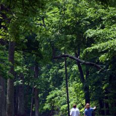
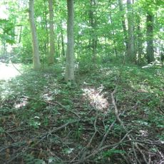
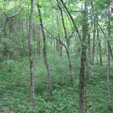
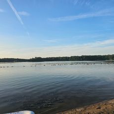
Culberson Woods is a nature preserve featuring a forest with red maples, oaks, hickories, elms, and sweetgum trees that together form a swamp woodland landscape. Trails wind through the area, allowing visitors to walk among the trees and observe the plant life.

The preserve began in 1978 when Myra Culberson donated the initial section to honor Dean A. Culberson. The protected area has grown since then and now preserves this forest type that once spread across the region.

The forest shows the kind of trees and plants that once covered much of this region before the land changed. Walking through it today, you see a living example of how the Till Plains looked generations ago.

A flat loop trail takes visitors through the preserve and is easy to walk for most people. The ground gets muddy and slippery after rain, so wearing sturdy shoes is wise in damp conditions.

The light clay soil here creates distinct seasons within the forest. In winter the ground stays wet and boggy, while in summer it dries out and becomes firmer underfoot.

The community of curious travelers

AroundUs brings together thousands of curated places, local tips, and hidden gems, enriched daily by 60,000 contributors worldwide.

Start exploring
Location
GPS coordinates
39.37000,-83.93330
Latest update
December 14, 2025 16:47
Around this place
Caesar Creek State Park
United States of America

Caesar Creek State Park

18.3 km
Golden Lamb Inn
United States of America

Golden Lamb Inn

24.7 km
Fort Ancient
United States of America

Fort Ancient

14.1 km
Jeremiah Morrow Bridge
United States of America

Jeremiah Morrow Bridge

15.7 km
Murphy Theatre
United States of America

Murphy Theatre

12.2 km
Cowan Lake State Park
United States of America

Cowan Lake State Park

3.2 km
Stonelick State Park
United States of America

Stonelick State Park

20.4 km
Lebanon Mason Monroe Railroad
United States of America

Lebanon Mason Monroe Railroad

24.6 km
Cowan Lake
United States of America

Cowan Lake

3.4 km
Wilmington Public Library of Clinton County, Ohio
United States of America

Wilmington Public Library of Clinton County, Ohio

12.6 km
Beam Farm Woodland Archaeological District
United States of America

Beam Farm Woodland Archaeological District

22.8 km
Keiter Mound
United States of America

Keiter Mound

20.3 km
Lynchburg Covered Bridge
United States of America

Lynchburg Covered Bridge

18.3 km
Bone Stone Graves
United States of America

Bone Stone Graves

20.4 km
Glendower State Memorial
United States of America

Glendower State Memorial

24.7 km
Williams Stadium
United States of America

Williams Stadium

12.6 km
Hillside Haven Mound
United States of America

Hillside Haven Mound

9.8 km
Cowan Creek Circular Enclosure
United States of America

Cowan Creek Circular Enclosure

3 km
Bone Mound II
United States of America

Bone Mound II

20.5 km
Doan House
United States of America

Doan House

13.3 km
Martinsville Road Covered Bridge
United States of America

Martinsville Road Covered Bridge

9.6 km
Waynesville Main Street Historic District
United States of America

Waynesville Main Street Historic District

22.1 km
McCafferty Road Covered Bridge
United States of America

McCafferty Road Covered Bridge

24.9 km
Mohrman-Jack-Evans House
United States of America

Mohrman-Jack-Evans House

24.1 km
Moar Mound and Village Site
United States of America

Moar Mound and Village Site

22.6 km
Waynesville Greek Revival Houses
United States of America

Waynesville Greek Revival Houses

22 km
Cowan Lake Public Beach
United States of America

Cowan Lake Public Beach

3.2 km
Harmon Museum
United States of America

Harmon Museum

24.7 km
Show the full map
Reviews
Share your experience

No review yet

Discussions
Start a discussion...

No discussion yet

« Culberson Woods State Nature Preserve - Nature preserve in Clinton County, Ohio, US » is provided by Around Us (aroundus.com). Images and texts are derived from Wikimedia project under a Creative Commons license. You are allowed to copy, distribute, and modify copies of this page, under the conditions set by the license, as long as this note is clearly visible.

Discover hidden gems everywhere you go!

From secret cafés to breathtaking viewpoints, skip the crowded tourist spots and find places that match your style. Our app makes it easy with voice search, smart filtering, route optimization, and insider tips from travelers worldwide. Download now for the complete mobile experience.

Around Us App Screenshot

A unique approach to discovering new places

Le Figaro

All the places worth exploring

France Info

A tailor-made excursion in just a few clicks

20 Minutes

Around Us
Travel Guide & Maps
Download

Send to your phone

QR Code
1

Open the camera app on your mobile.

2

Point at the QR code with your camera. A notification will appear.

3

Tap the notification to open the link.