Dayton Street Historic District

Log in to your account

AroundUs is a community-driven map of interesting places, built by curious explorers like you. It grows with every review, story, and photo you share.
Connect to save your favorite spots, contribute locations, and create personalized routes.
Continue with Google
Continue with Apple
Continue with X
Continue with Facebook
Continue with email
By continuing, you accept our Terms and Conditions and our Privacy Policy
Create an account
Add to collection
Map
Suggest a change
Share

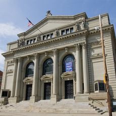
Dayton Street Historic District, Historic district in Old West End, Cincinnati, United States.

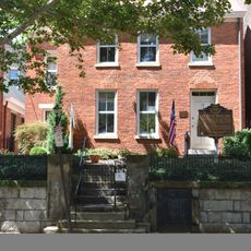
The Dayton Street Historic District is a residential area in Cincinnati's Old West End featuring homes built in Renaissance Revival style during the 1800s. Spanning four blocks between Bank Street, Poplar Street, Linn Street, and Winchell Avenue, it preserves original stone retaining walls, ornamental ironwork, and hundreds of period residences with detailed architectural features.

The area developed between 1850 and 1890 when wealthy industrialists from meat processing and brewing industries built grand mansions there. This period of construction transformed the location into a symbol of industrial wealth and success in Cincinnati's economy.

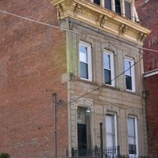
The name refers to the street that forms the heart of this residential zone, lined with homes displaying the tastes of those who built them. Walking through, you notice how ornate stonework and iron details on facades reflect the owners' status and the era's preference for displaying wealth through architectural embellishment.

The district is best explored on foot, allowing you to see architectural details on the homes as you walk through the neighborhood. The area is accessible from multiple entry points along its surrounding streets, making it easy to view properties from different angles and perspectives.

Several homes showcase Italianate design with multi-story structures that architect George W. Skaats created during the district's development. These residences stand apart for their detached configurations and construction methods that were common in the 1860s.

Location: Ohio

Inception: 1860

Architectural style: Renaissance Revival architecture

GPS coordinates: 39.11750,-84.53056

Latest update: December 12, 2025 14:25

Photos
Around this place
Cincinnati Music Hall
United States of America

Cincinnati Music Hall

1.3 km
Findlay Market
United States of America

Findlay Market

1 km
Cathedral Basilica of St. Peter in Chains
United States of America

Cathedral Basilica of St. Peter in Chains

1.8 km
Cincinnati Museum Center at Union Terminal
United States of America

Cincinnati Museum Center at Union Terminal

1 km
Cincinnati Museum Center at Union Terminal
United States of America

Cincinnati Museum Center at Union Terminal

1 km
Cincinnati City Hall
United States of America

Cincinnati City Hall

1.8 km
American Classical Music Hall of Fame and Museum
United States of America

American Classical Music Hall of Fame and Museum

1.4 km
St. Francis Xavier Church
United States of America

St. Francis Xavier Church

1.3 km
Betts House
United States of America

Betts House

1.3 km
Laurel Homes Historic District
United States of America

Laurel Homes Historic District

873 m
Hamilton County Memorial Building
United States of America

Hamilton County Memorial Building

1.4 km
Lloyd Library and Museum
United States of America

Lloyd Library and Museum

1.7 km
Bellevue Hill Park
United States of America

Bellevue Hill Park

1 km
The Children's Museum
United States of America

The Children's Museum

1 km
John Hauck House
United States of America

John Hauck House

287 m
Betts-Longworth Historic District
United States of America

Betts-Longworth Historic District

1.3 km
Van Wormer Hall
United States of America

Van Wormer Hall

1.8 km
Apostolic Bethlehem Temple Church
United States of America

Apostolic Bethlehem Temple Church

1.5 km
Goodall Building
United States of America

Goodall Building

1.7 km
S. C. Mayer House
United States of America

S. C. Mayer House

1.7 km
Heinrich A. Rattermann House
United States of America

Heinrich A. Rattermann House

601 m
Joseph A. Hemann House
United States of America

Joseph A. Hemann House

1.8 km
Western Hills Viaduct
United States of America

Western Hills Viaduct

1.3 km
Cincinnati Union Terminal
United States of America

Cincinnati Union Terminal

1 km
Ohio National Guard Armory
United States of America

Ohio National Guard Armory

701 m
Cincinnati History Museum
United States of America

Cincinnati History Museum

1.1 km
Stargel Stadium
United States of America

Stargel Stadium

1.2 km
Over-the-Rhine Historic District
United States of America

Over-the-Rhine Historic District

1.2 km
Show the full map
Reviews

Visited this place? Tap the stars to rate it and share your experience / photos with the community! Try now! You can cancel it anytime.

« Dayton Street Historic District - Historic district in Old West End, Cincinnati, United States » is provided by Around Us (aroundus.com). Images and texts are derived from Wikimedia project under a Creative Commons license. You are allowed to copy, distribute, and modify copies of this page, under the conditions set by the license, as long as this note is clearly visible.

Discover hidden gems everywhere you go!

From secret cafés to breathtaking viewpoints, skip the crowded tourist spots and find places that match your style. Our app makes it easy with voice search, smart filtering, route optimization, and insider tips from travelers worldwide. Download now for the complete mobile experience.

Around Us App Screenshot

A unique approach to discovering new places

Le Figaro

All the places worth exploring

France Info

A tailor-made excursion in just a few clicks

20 Minutes