Laurel Homes Historic District

Log in to your account

AroundUs is a community-driven map of interesting places, built by curious explorers like you. It grows with every review, story, and photo you share.
Connect to save your favorite spots, contribute locations, and create personalized routes.
Continue with Google
Continue with Apple
Continue with X
Continue with Facebook
Continue with email
By continuing, you accept our Terms and Conditions and our Privacy Policy
Create an account
Add to collection
Map
Suggest a change
Share

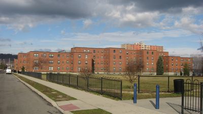
Laurel Homes Historic District, Historic district in West End, Cincinnati, United States.

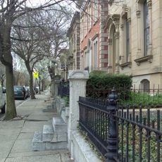
Laurel Homes Historic District is a residential area in Cincinnati's West End containing about 30 buildings across 34 acres. The structures sit between Liberty Street, John Street, Ezzard Charles Drive, and Linn Street, forming a cohesive housing community with connected street patterns.

The district was built in 1938 as one of the nation's largest federally funded housing projects during the Depression era. Its creation reflected a major shift in how government approached the housing crisis facing American families at that time.

The district reflects a moment when housing policy began to challenge residential separation, bringing families of different backgrounds into close proximity. Walking through, you notice how the architecture reinforces this original intent with shared community spaces and unified street frontages.

The area is straightforward to explore on foot with a regular street grid that makes navigation easy. Most buildings are visible from public streets, allowing visitors to appreciate the architecture and community design without restriction.

Frederick W. Garber, a respected architect who had previously designed the Woolworth Building in Kentucky, led the design of these homes. His involvement brought polished architectural standards to what might have otherwise been a more utilitarian housing project.

Location: Cincinnati

GPS coordinates: 39.11140,-84.52420

Latest update: December 12, 2025 14:26

Photos
Around this place
Cincinnati Music Hall
United States of America

Cincinnati Music Hall

508 m
Findlay Market
United States of America

Findlay Market

613 m
Cathedral Basilica of St. Peter in Chains
United States of America

Cathedral Basilica of St. Peter in Chains

978 m
Isaac M. Wise Temple
United States of America

Isaac M. Wise Temple

1 km
Cincinnati City Hall
United States of America

Cincinnati City Hall

899 m
Emery Theatre
United States of America

Emery Theatre

1 km
American Classical Music Hall of Fame and Museum
United States of America

American Classical Music Hall of Fame and Museum

583 m
St. Francis Xavier Church
United States of America

St. Francis Xavier Church

708 m
Betts House
United States of America

Betts House

440 m
Piatt Park
United States of America

Piatt Park

1.1 km
Dayton Street Historic District
United States of America

Dayton Street Historic District

873 m
Hamilton County Memorial Building
United States of America

Hamilton County Memorial Building

594 m
Lloyd Library and Museum
United States of America

Lloyd Library and Museum

807 m
Equestrian statue of William Henry Harrison
United States of America

Equestrian statue of William Henry Harrison

1 km
John Hauck House
United States of America

John Hauck House

816 m
Brittany Apartment Building
United States of America

Brittany Apartment Building

994 m
Betts-Longworth Historic District
United States of America

Betts-Longworth Historic District

490 m
Saxony Apartment Building
United States of America

Saxony Apartment Building

995 m
St. Paul Episcopal Cathedral, Cincinnati
United States of America

St. Paul Episcopal Cathedral, Cincinnati

1.1 km
Ninth Street Historic District
United States of America

Ninth Street Historic District

1 km
Apostolic Bethlehem Temple Church
United States of America

Apostolic Bethlehem Temple Church

610 m
Phoenix Club
United States of America

Phoenix Club

1 km
Goodall Building
United States of America

Goodall Building

849 m
S. C. Mayer House
United States of America

S. C. Mayer House

1.1 km
Heinrich A. Rattermann House
United States of America

Heinrich A. Rattermann House

650 m
Ohio National Guard Armory
United States of America

Ohio National Guard Armory

717 m
Stargel Stadium
United States of America

Stargel Stadium

351 m
Kroger Building
United States of America

Kroger Building

1 km
Show the full map
Reviews

Visited this place? Tap the stars to rate it and share your experience / photos with the community! Try now! You can cancel it anytime.

« Laurel Homes Historic District - Historic district in West End, Cincinnati, United States » is provided by Around Us (aroundus.com). Images and texts are derived from Wikimedia project under a Creative Commons license. You are allowed to copy, distribute, and modify copies of this page, under the conditions set by the license, as long as this note is clearly visible.

Discover hidden gems everywhere you go!

From secret cafés to breathtaking viewpoints, skip the crowded tourist spots and find places that match your style. Our app makes it easy with voice search, smart filtering, route optimization, and insider tips from travelers worldwide. Download now for the complete mobile experience.

Around Us App Screenshot

A unique approach to discovering new places

Le Figaro

All the places worth exploring

France Info

A tailor-made excursion in just a few clicks

20 Minutes