Dale Hollow Reservoir

Log in to your account

AroundUs is a community-driven map of interesting places, built by curious explorers like you. It grows with every review, story, and photo you share.
Connect to save your favorite spots, contribute locations, and create personalized routes.
By continuing, you accept our Terms and Conditions and our Privacy Policy

Dale Hollow Reservoir

Add to collection
Map
Suggest a change
Share

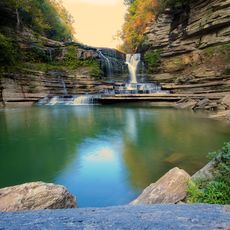
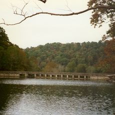
Dale Hollow Reservoir, Flood control reservoir in Clay County and Pickett County, United States.

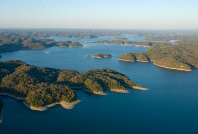
Dale Hollow Reservoir is a body of water on the border between Tennessee and Kentucky with a surface of roughly 27,700 acres and about 620 miles of shoreline. The water stretches across four counties and offers many branching coves and forested slopes along its edges.

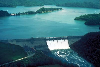
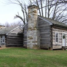
The United States Army Corps of Engineers finished building Dale Hollow Dam in 1943 to control flooding and generate power. The flooding of the valley led to the relocation of several communities, including the town of Willow Grove.

The name comes from the original Dale Hollow valley that was flooded when the dam was finished. Today anglers and boaters use the quiet coves along the shore, while others swim at the shallow beaches or picnic in small groups.

Four developed campgrounds with electric and water hookups sit at different spots along the shore and provide access to boat ramps and swimming beaches. The quieter coves work well for fishing and kayaking, while the open areas suit motorboats.

In 1955 an angler here caught a smallmouth bass weighing 11 pounds and 15 ounces (5.4 kilograms), which remains the world record for the species. This catch made the reservoir known internationally among sport fishers.

Location: Clay County

Location: Pickett County

Location: Overton County

Location: Clinton County

GPS coordinates: 36.53673,-85.45163

Latest update: December 5, 2025 22:24

Around this place
Show the full map
Cummins Falls State Park
United States of America

Cummins Falls State Park

33.1 km
Cummins Falls
United States of America

Cummins Falls

33.8 km
Sgt. Alvin C. York State Historic Park
United States of America

Sgt. Alvin C. York State Historic Park

43.9 km
Standing Stone State Park
United States of America

Standing Stone State Park

8 km
Alvin C. York Institute
United States of America

Alvin C. York Institute

47.2 km
Tucker Stadium
United States of America

Tucker Stadium

40.2 km
Donoho Hotel
United States of America

Donoho Hotel

34.8 km
Creelsboro Natural Bridge
United States of America

Creelsboro Natural Bridge

43.3 km
Cordell Hull Birthplace State Park
United States of America

Cordell Hull Birthplace State Park

24.6 km
Fort Blount
United States of America

Fort Blount

36.2 km
White Plains
United States of America

White Plains

39.7 km
Old Mulkey Meetinghouse State Historic Site
United States of America

Old Mulkey Meetinghouse State Historic Site

27.7 km
Alpine Institute
United States of America

Alpine Institute

26.3 km
Broad Street Church of Christ
United States of America

Broad Street Church of Christ

42 km
Pickett County Courthouse
United States of America

Pickett County Courthouse

29.1 km
Algood United Methodist Church
United States of America

Algood United Methodist Church

38.2 km
Judge Killis Huddleston House
United States of America

Judge Killis Huddleston House

36.1 km
Sgt. Alvin C. York State Historic Park
United States of America

Sgt. Alvin C. York State Historic Park

44 km
Mount Vernon AME Church
United States of America

Mount Vernon AME Church

34.6 km
Marrowbone Historic District
United States of America

Marrowbone Historic District

32.8 km
Jesse Noland House
United States of America

Jesse Noland House

34 km
Clay County Courthouse
United States of America

Clay County Courthouse

5.1 km
James Baker House
United States of America

James Baker House

36.5 km
Coe House
United States of America

Coe House

29.9 km
Old Mulkey Meetinghouse
United States of America

Old Mulkey Meetinghouse

27.7 km
Sgt. Alvin C. York State Historic Park Visitor Center
United States of America

Sgt. Alvin C. York State Historic Park Visitor Center

44 km
Standing Stone Rustic Park Historic District
United States of America

Standing Stone Rustic Park Historic District

8 km
Cumberland County Courthouse
United States of America

Cumberland County Courthouse

29.1 km
Show the full map

Reviews

Visited this place? Tap the stars to rate it and share your experience / photos with the community! Try now! You can cancel it anytime.

« Dale Hollow Reservoir - Flood control reservoir in Clay County and Pickett County, United States » is provided by Around Us (aroundus.com). Images and texts are derived from Wikimedia project under a Creative Commons license. You are allowed to copy, distribute, and modify copies of this page, under the conditions set by the license, as long as this note is clearly visible.

Discover hidden gems everywhere you go!

From secret cafés to breathtaking viewpoints, skip the crowded tourist spots and find places that match your style. Our app makes it easy with voice search, smart filtering, route optimization, and insider tips from travelers worldwide. Download now for the complete mobile experience.

Around Us App Screenshot

A unique approach to discovering new places

Le Figaro

All the places worth exploring

France Info

A tailor-made excursion in just a few clicks

20 Minutes