Earnest Farms Historic District

Log in to your account

AroundUs is a community-driven map of interesting places, built by curious explorers like you. It grows with every review, story, and photo you share.
Connect to save your favorite spots, contribute locations, and create personalized routes.
Continue with Google
Continue with Apple
Continue with X
Continue with Facebook
Continue with email
By continuing, you accept our Terms and Conditions and our Privacy Policy
Create an account
Add to collection
Map
Suggest a change
Share

Earnest Farms Historic District, Agricultural historic district near Chuckey, Tennessee

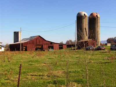
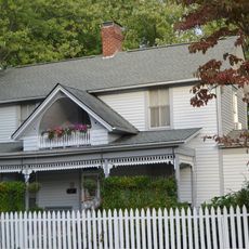
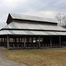
The Earnest Farms Historic District is an agricultural area near Chuckey containing four separate farms spread across 900 acres with mixed architectural styles from different periods. The buildings display Federal, Bungalow, and Italianate design elements that represent the layers of development across the farming properties.

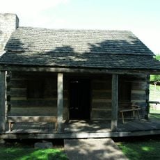
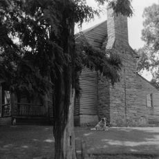
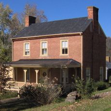
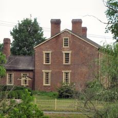
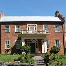
Henry Earnest founded the first farm in 1782, building the Earnest Fort House with limestone and logs, which marked the start of agricultural settlement in Greene County. This early establishment became the foundation for additional farms and a Methodist congregation that organized in the following decades.

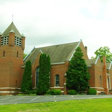
The Ebenezer Methodist Church reflects the strong faith-based community that developed here, with its origins traced to a land donation by Henry Earnest in 1795. Visitors can observe how religious life shaped the social fabric of the farming families who settled this region.

Access to the district is best gained from Tennessee State Route 351, which passes through Elmwood Farm and provides direct entry to the historic structures. A vehicle is helpful for visiting the different properties spread across the area and viewing the various buildings at your own pace.

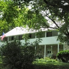
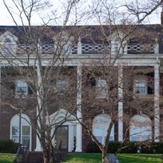
Elmwood Farm is one of Tennessee's oldest continuously farmed properties, with cultivation records dating back to 1777, predating even the official establishment of the first farmstead. This unbroken agricultural tradition spans more than two centuries of land use by successive farming families.

Location: Tennessee

Inception: 1782

GPS coordinates: 36.19833,-82.68083

Latest update: December 12, 2025 17:43

Photos
Around this place
United States of America

Gray Fossil Site

26.6 km
Andrew Johnson National Cemetery
United States of America

Andrew Johnson National Cemetery

14.9 km
William B. Greene Jr. Stadium
United States of America

William B. Greene Jr. Stadium

29.7 km
Boone Lake
United States of America

Boone Lake

34.6 km
Davy Crockett Birthplace State Park
United States of America

Davy Crockett Birthplace State Park

2.3 km
Tipton-Haynes State Historic Site
United States of America

Tipton-Haynes State Historic Site

32.8 km
Mountain Home National Cemetery
United States of America

Mountain Home National Cemetery

30.1 km
Amis House
United States of America

Amis House

34.8 km
Greeneville Historic District
United States of America

Greeneville Historic District

14 km
Jonesborough Historic District
United States of America

Jonesborough Historic District

21.4 km
Lamar Alexander Rocky Fork State Park
United States of America

Lamar Alexander Rocky Fork State Park

19.2 km
Aquone
United States of America

Aquone

31.6 km
Maden Hall Farm
United States of America

Maden Hall Farm

10.4 km
Shelbridge
United States of America

Shelbridge

31.8 km
New Providence Presbyterian Church, Academy, and Cemetery
United States of America

New Providence Presbyterian Church, Academy, and Cemetery

35.5 km
Salem Presbyterian Church
United States of America

Salem Presbyterian Church

10 km
Stony Point
United States of America

Stony Point

34.7 km
Holiday Lanes
United States of America

Holiday Lanes

32 km
Mountain Branch, National Home for Disabled Volunteer Soldiers
United States of America

Mountain Branch, National Home for Disabled Volunteer Soldiers

30.3 km
Thankful Baptist Church
United States of America

Thankful Baptist Church

32.5 km
A.R. Brown House
United States of America

A.R. Brown House

24.3 km
Thomas Telford House
United States of America

Thomas Telford House

6.9 km
Jonesborough United Methodist Church
United States of America

Jonesborough United Methodist Church

21.2 km
Henry Hoss House
United States of America

Henry Hoss House

22.9 km
Gate City Historic District
United States of America

Gate City Historic District

14.8 km
Waterfall on West Prong Hickey Fork
United States of America

Waterfall on West Prong Hickey Fork

22.8 km
Sulphur Springs Methodist Campground
United States of America

Sulphur Springs Methodist Campground

20.8 km
Olympia Lanes
United States of America

Olympia Lanes

12.2 km
Show the full map
Reviews

Visited this place? Tap the stars to rate it and share your experience / photos with the community! Try now! You can cancel it anytime.

« Earnest Farms Historic District - Agricultural historic district near Chuckey, Tennessee » is provided by Around Us (aroundus.com). Images and texts are derived from Wikimedia project under a Creative Commons license. You are allowed to copy, distribute, and modify copies of this page, under the conditions set by the license, as long as this note is clearly visible.

Discover hidden gems everywhere you go!

From secret cafés to breathtaking viewpoints, skip the crowded tourist spots and find places that match your style. Our app makes it easy with voice search, smart filtering, route optimization, and insider tips from travelers worldwide. Download now for the complete mobile experience.

Around Us App Screenshot

A unique approach to discovering new places

Le Figaro

All the places worth exploring

France Info

A tailor-made excursion in just a few clicks

20 Minutes