Enable Location

We need your location to show you interesting places around you

Discover nearby places

Find interesting locations and hidden gems around you

Precise directions

Get accurate directions and distances to places

Your location is never shared with other users. It's only used when you tap the location button.

Eaton High School

Log in to your account

Start exploring — it's free

Trusted by 63,832 travelers worldwide

Continue with Google
Continue with Apple
or

We will send you a code to connect

By continuing, you accept our Terms and Conditions and our Privacy Policy

Check your inbox

We've sent a pincode in your inbox. Please enter the code below.

Discussion Reviews 1 Photos
2.8k Popularity

Eaton High School, high school in Eaton, Preble County, Ohio

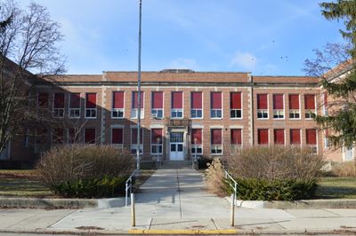
Eaton High School is a school building in Eaton, Ohio, constructed in 1927 in the Classical Revival style. The brick structure with stone trim has an H-shaped footprint that creates a central courtyard, and preserves original interior features including terrazzo floors, woodwork, and glazed brick wainscoting.

The school was built in 1927 and served as a community center until 2012. Architect William B. Ittner designed the building using modern educational principles with natural light and good ventilation, influencing school design standards of his era.

The school carries the name of the town of Eaton and is deeply tied to the community's identity. Local residents connect the building with personal memories of friendships, school events, and the ongoing life of their community.

The building sits on a main street and is easy to reach on foot. Access to the former school is through the east-facing main entrance, marked by two large stone lampposts, which helps with orientation when approaching the site.

The building was converted to apartments named Residences at Eagles Point in 2017. This transformation preserved the historic brick structure while giving the building new life, allowing residents to live within a piece of local history.

The community of curious travelers

AroundUs brings together thousands of curated places, local tips, and hidden gems, enriched daily by 60,000 contributors worldwide.

Start exploring
Location
GPS coordinates
39.73310,-84.64890
Latest update
February 9, 2026 08:23
Around this place
Hueston Woods State Park
United States of America

Hueston Woods State Park

19.3 km
Roberts Covered Bridge
United States of America

Roberts Covered Bridge

1.2 km
Reid Memorial Presbyterian Church
United States of America

Reid Memorial Presbyterian Church

23.2 km
Abram Gaar House and Farm
United States of America

Abram Gaar House and Farm

22.7 km
Brubaker Covered Bridge
United States of America

Brubaker Covered Bridge

12.7 km
Old Richmond Historic District
United States of America

Old Richmond Historic District

23.1 km
Starr Historic District
United States of America

Starr Historic District

22.5 km
Richmond Downtown Historic District
United States of America

Richmond Downtown Historic District

23.3 km
Henry and Alice Gennett House
United States of America

Henry and Alice Gennett House

22.3 km
Forest Hills Country Club
United States of America

Forest Hills Country Club

20.5 km
Christman Covered Bridge
United States of America

Christman Covered Bridge

4.2 km
Howe Tavern
United States of America

Howe Tavern

23.3 km
Reeveston Place Historic District
United States of America

Reeveston Place Historic District

22.9 km
Hopewell Associate Reformed Presbyterian Church
United States of America

Hopewell Associate Reformed Presbyterian Church

17.3 km
Richmond Civic Theater
United States of America

Richmond Civic Theater

23.1 km
East Main Street-Glen Miller Park Historic District
United States of America

East Main Street-Glen Miller Park Historic District

21.5 km
Bethel A.M.E. Church
United States of America

Bethel A.M.E. Church

23.4 km
Warnke Covered Bridge
United States of America

Warnke Covered Bridge

19.4 km
Geeting Covered Bridge
United States of America

Geeting Covered Bridge

13.1 km
Acton House
United States of America

Acton House

1.6 km
Harshman Covered Bridge
United States of America

Harshman Covered Bridge

10.9 km
Unzicker-Cook House
United States of America

Unzicker-Cook House

21.8 km
Andrew F. Scott House
United States of America

Andrew F. Scott House

23.3 km
Model T Museum
United States of America

Model T Museum

23.5 km
Preble County Historical Society and Nature Reserve
United States of America

Preble County Historical Society and Nature Reserve

12.1 km
Dixon's Branch Bridge
United States of America

Dixon's Branch Bridge

15.9 km
Saint Clair Street Bridge
United States of America

Saint Clair Street Bridge

1.2 km
Roberts Bridge
United States of America

Roberts Bridge

1.2 km
Show the full map
Reviews
Share your experience

No review yet

Discussions
Start a discussion...

No discussion yet

« Eaton High School - high school in Eaton, Preble County, Ohio » is provided by Around Us (aroundus.com). Images and texts are derived from Wikimedia project under a Creative Commons license. You are allowed to copy, distribute, and modify copies of this page, under the conditions set by the license, as long as this note is clearly visible.

Discover hidden gems everywhere you go!

From secret cafés to breathtaking viewpoints, skip the crowded tourist spots and find places that match your style. Our app makes it easy with voice search, smart filtering, route optimization, and insider tips from travelers worldwide. Download now for the complete mobile experience.

Around Us App Screenshot

A unique approach to discovering new places

Le Figaro

All the places worth exploring

France Info

A tailor-made excursion in just a few clicks

20 Minutes

Around Us
Travel Guide & Maps
Download

Send to your phone

QR Code
1

Open the camera app on your mobile.

2

Point at the QR code with your camera. A notification will appear.

3

Tap the notification to open the link.