Log in to your account

AroundUs is a community-driven map of interesting places, built by curious explorers like you. It grows with every review, story, and photo you share.
Connect to save your favorite spots, contribute locations, and create personalized routes.
Continue with Google
Continue with Apple
Continue with X
Continue with Facebook
Continue with email
By continuing, you accept our Terms and Conditions and our Privacy Policy
Create an account
Add to collection
Map
Suggest a change
Share

Fires Creek, Protected area in Clay County, North Carolina.

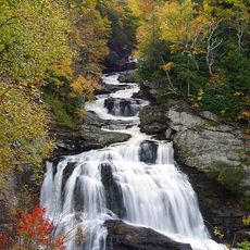
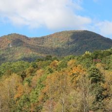
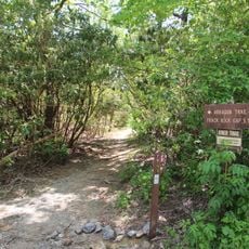
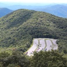
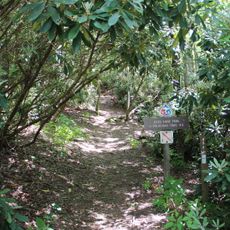
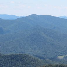
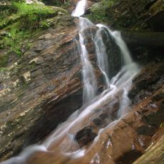
Fires Creek is a protected area spanning over 20,000 acres within Nantahala National Forest, featuring forested hillsides, flowing streams, and multiple hiking trails throughout. The landscape offers varied terrain for outdoor activities set among rolling woodland.

The area took its name from one of the first European settlers who established residence here during early colonial times. This early settlement marked the beginning of the region's recorded history.

The landscape holds traces of Cherokee presence in geological features like the basins at Potrock Bald, places where Native people may have prepared food and lived off the land. These natural formations still tell stories about the connection between people and the environment in this region.

The main trail is marked with blue blazes and runs around the area, with the picnic area serving as a convenient starting point for exploration. Visitors should be prepared for changing elevations and wear sturdy footwear since the paths cross hilly and sometimes uneven terrain.

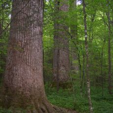
The area functions as a sanctuary for black bears, providing them with natural habitat alongside multiple pine species. This balance between wildlife protection and forest diversity makes it a special place for those seeking to experience undisturbed wilderness.

Location: North Carolina

GPS coordinates: 35.13290,-83.80520

Latest update: December 14, 2025 17:43

Photos
Around this place
Brasstown Bald
United States of America

Brasstown Bald

28.8 km
Nantahala National Forest
United States of America

Nantahala National Forest

25 km
Chatuge Lake
United States of America

Chatuge Lake

15.9 km
Joyce Kilmer Memorial Forest
United States of America

Joyce Kilmer Memorial Forest

31 km
John C. Campbell Folk School
United States of America

John C. Campbell Folk School

18.1 km
United States of America

Track Rock

28.7 km
Joyce Kilmer-Slickrock Wilderness
United States of America

Joyce Kilmer-Slickrock Wilderness

31 km
Santeetlah Dam
United States of America

Santeetlah Dam

28 km
Southern Nantahala Wilderness
United States of America

Southern Nantahala Wilderness

26.7 km
Arkaquah Trail
United States of America

Arkaquah Trail

28.8 km
Wolfpen Ridge
United States of America

Wolfpen Ridge

30 km
Jacks Knob Trail
United States of America

Jacks Knob Trail

31.6 km
Fred Hamilton Rhododendron Garden
United States of America

Fred Hamilton Rhododendron Garden

12.9 km
Double Spring Knob
United States of America

Double Spring Knob

31.4 km
John Franklin Cobb House
United States of America

John Franklin Cobb House

29.3 km
Spikebuck Town Mound and Village Site
United States of America

Spikebuck Town Mound and Village Site

9.7 km
Robert Lafayette Cooper House
United States of America

Robert Lafayette Cooper House

21.2 km
Cherokee County Courthouse
United States of America

Cherokee County Courthouse

21.4 km
First Baptist Church
United States of America

First Baptist Church

7.7 km
Bull Cove Falls
United States of America

Bull Cove Falls

27.9 km
Franklin Pierce Cover House
United States of America

Franklin Pierce Cover House

7.9 km
Towns County Jail
United States of America

Towns County Jail

21.2 km
Graham County Courthouse
United States of America

Graham County Courthouse

21.1 km
Young Harris College Historic District
United States of America

Young Harris College Historic District

22.6 km
Old Union County Courthouse
United States of America

Old Union County Courthouse

31.8 km
Raburn-Casteel House
United States of America

Raburn-Casteel House

31.2 km
Clay County Courthouse
United States of America

Clay County Courthouse

9.8 km
Charles Noden George House
United States of America

Charles Noden George House

19.2 km
Show the full map
Reviews

Visited this place? Tap the stars to rate it and share your experience / photos with the community! Try now! You can cancel it anytime.

« Fires Creek - Protected area in Clay County, North Carolina » is provided by Around Us (aroundus.com). Images and texts are derived from Wikimedia project under a Creative Commons license. You are allowed to copy, distribute, and modify copies of this page, under the conditions set by the license, as long as this note is clearly visible.

Discover hidden gems everywhere you go!

From secret cafés to breathtaking viewpoints, skip the crowded tourist spots and find places that match your style. Our app makes it easy with voice search, smart filtering, route optimization, and insider tips from travelers worldwide. Download now for the complete mobile experience.

Around Us App Screenshot

A unique approach to discovering new places

Le Figaro

All the places worth exploring

France Info

A tailor-made excursion in just a few clicks

20 Minutes