·

Enable Location

We need your location to show you interesting places around you

Discover nearby places

Find interesting locations and hidden gems around you

Precise directions

Get accurate directions and distances to places

Your location is never shared with other users. It's only used when you tap the location button.

Kezenoyam

Log in to your account

Start exploring — it's free

Trusted by 62,653 travelers worldwide

Continue with Google
Continue with Apple
or

We will send you a code to connect

By continuing, you accept our Terms and Conditions and our Privacy Policy

Check your inbox

We've sent a pincode in your inbox. Please enter the code below.

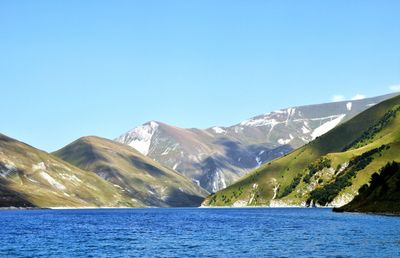
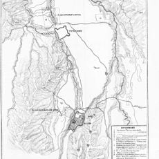
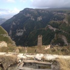
Kezenoyam, Alpine lake at Vedensky and Botlikhsky districts, Russia.

Kezenoyam sits at 1854 meters above sea level on the border between Chechnya and Dagestan, extending nearly three kilometers from west to east. The water reaches depths of up to 74 meters in places, filling a basin framed by forested slopes and mountain ridges.

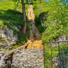
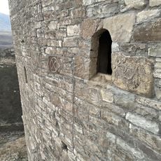
The body of water formed when a landslide blocked a river centuries ago, flooding the valley below. Herders and hunters have used the surrounding area ever since as grazing ground and a source of drinking water in the highlands of the North Caucasus.

The waters of Kezenoyam feature in numerous tales of the Chechen and Dagestani peoples, reflecting their connection to this natural formation.

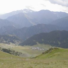
The drive from Grozny takes about two hours, with the final 30 kilometers following narrow mountain roads that can become slippery in rain. Visitors arriving in summer will find shallow spots along the shore for wading and shaded areas beneath trees.

The clear water is home to a species of trout found nowhere else on Earth, adapted over thousands of years to the cold conditions. Researchers monitor this population to better understand the ecosystem of isolated high-mountain lakes.

The community of curious travelers

AroundUs brings together thousands of curated places, local tips, and hidden gems, enriched daily by 60,000 contributors worldwide.

Start exploring
Location
Location
Elevation above the sea
1,854 m
GPS coordinates
42.77722,46.15306
Latest update
December 19, 2025 23:24
Around this place
Pride of Muslims
Russian Federation

Pride of Muslims

46.9 km
Pitkäranta District
Russian Federation

Pitkäranta District

44.6 km
Ushkaloy Towers
Russian Federation

Ushkaloy Towers

43.7 km
Nikhaloy waterfalls
Russian Federation

Nikhaloy waterfalls

40.3 km
Хой (башня)
Russian Federation

Хой (башня)

3.2 km
Хаскалинская боевая башня
Russian Federation

Хаскалинская боевая башня

47.4 km
Preobragenskaya Fortres
Russian Federation

Preobragenskaya Fortres

16.8 km
Arqun Muzey-Qoruğu
Russian Federation

Arqun Muzey-Qoruğu

39.1 km
Dora
Russian Federation

Dora

47.4 km
Category:Shatoy historic & architectural complex
Russian Federation

Category:Shatoy historic & architectural complex

32.8 km
Shatoy towers
Russian Federation

Shatoy towers

39.6 km
Харачойский водопад
Russian Federation

Харачойский водопад

15.6 km
Махкетинский краеведческий музей
Russian Federation

Махкетинский краеведческий музей

28.8 km
Avtury Mosque
Russian Federation

Avtury Mosque

44.7 km
Айдамиров Абузаран Литературин-мемориалан музей
Russian Federation

Айдамиров Абузаран Литературин-мемориалан музей

46 km
Эткали
Russian Federation

Эткали

46 km
Крепость Ведено
Russian Federation

Крепость Ведено

21.4 km
Toumsoy Tower
Russian Federation

Toumsoy Tower

42.7 km
Dore II
Russian Federation

Dore II

47.1 km
Саттойская боевая башня
Russian Federation

Саттойская боевая башня

35.9 km
Харкаройская боевая башня
Russian Federation

Харкаройская боевая башня

9.1 km
Makazhoy Historical and Architectural Complex
Russian Federation

Makazhoy Historical and Architectural Complex

8.8 km
Шулгак
Russian Federation

Шулгак

46 km
Yurd-Aux məscidi
Russian Federation

Yurd-Aux məscidi

46.9 km
Canta-Aukh
Russian Federation

Canta-Aukh

35.9 km
Benoy Mosque
Russian Federation

Benoy Mosque

27.4 km
Селение Нижний Батлух (Нижний Батлух)
Russian Federation

Селение Нижний Батлух (Нижний Батлух)

44.3 km
Башня юго-западная (Нижнее Инхело)
Russian Federation

Башня юго-западная (Нижнее Инхело)

16.9 km
Show the full map
« Kezenoyam - Alpine lake at Vedensky and Botlikhsky districts, Russia » is provided by Around Us (aroundus.com). Images and texts are derived from Wikimedia project under a Creative Commons license. You are allowed to copy, distribute, and modify copies of this page, under the conditions set by the license, as long as this note is clearly visible.

Discover hidden gems everywhere you go!

From secret cafés to breathtaking viewpoints, skip the crowded tourist spots and find places that match your style. Our app makes it easy with voice search, smart filtering, route optimization, and insider tips from travelers worldwide. Download now for the complete mobile experience.

Around Us App Screenshot

A unique approach to discovering new places

Le Figaro

All the places worth exploring

France Info

A tailor-made excursion in just a few clicks

20 Minutes

Around Us
Travel Guide & Maps
Download

Send to your phone

QR Code
1

Open the camera app on your mobile.

2

Point at the QR code with your camera. A notification will appear.

3

Tap the notification to open the link.