See the monuments around you in AROpen chests in the app
Around Us is built for your phone — point your camera at the streets and discover the monuments and places around you in augmented reality.Around Us is built for your phone — chests unlock when you walk, explore and capture nearby places.
Maritime straits are among the most important sea passages in the world. These natural waterways between landmasses connect oceans and seas, allowing the movement of cargo ships, tankers, and container vessels. The Strait of Malacca between Malaysia and Indonesia is one of the busiest routes for trade between Asia and Europe. The Strait of Hormuz at the Persian Gulf separates Iran and Oman, forming an important passage for energy transport. The Strait of Gibraltar between Spain's coast and Morocco opens the Mediterranean to the Atlantic. The Bosphorus in Turkey connects the Black Sea to the Sea of Marmara and divides Istanbul across two continents.
Other passages shape remote waters. The Denmark Strait between Greenland and Iceland carries cold Arctic water into the Atlantic. The Bering Strait separates Russia from Alaska and links the Pacific to the Arctic Ocean. The Strait of Magellan at the southern tip of Chile offers a protected route between the Atlantic and Pacific. The Drake Passage between Chile and Antarctica is known as one of the roughest sea crossings. The Cook Strait divides New Zealand's North and South Islands. Additional straits like the Taiwan Strait, the Sunda Strait in Indonesia, the Mozambique Channel between Madagascar and Mozambique, the Florida Strait between the United States and Cuba, or the Dardanelles in Turkey play important roles in regional and international maritime traffic.
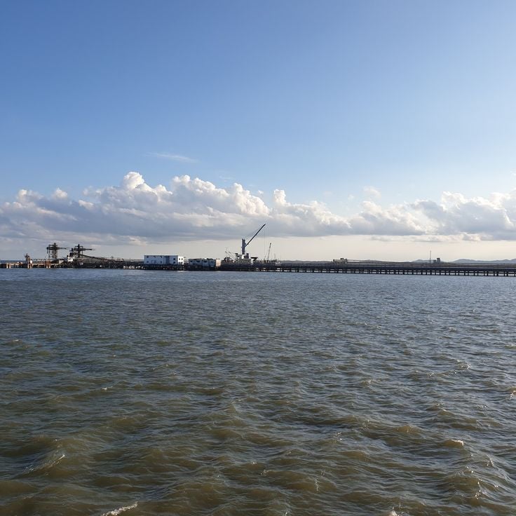
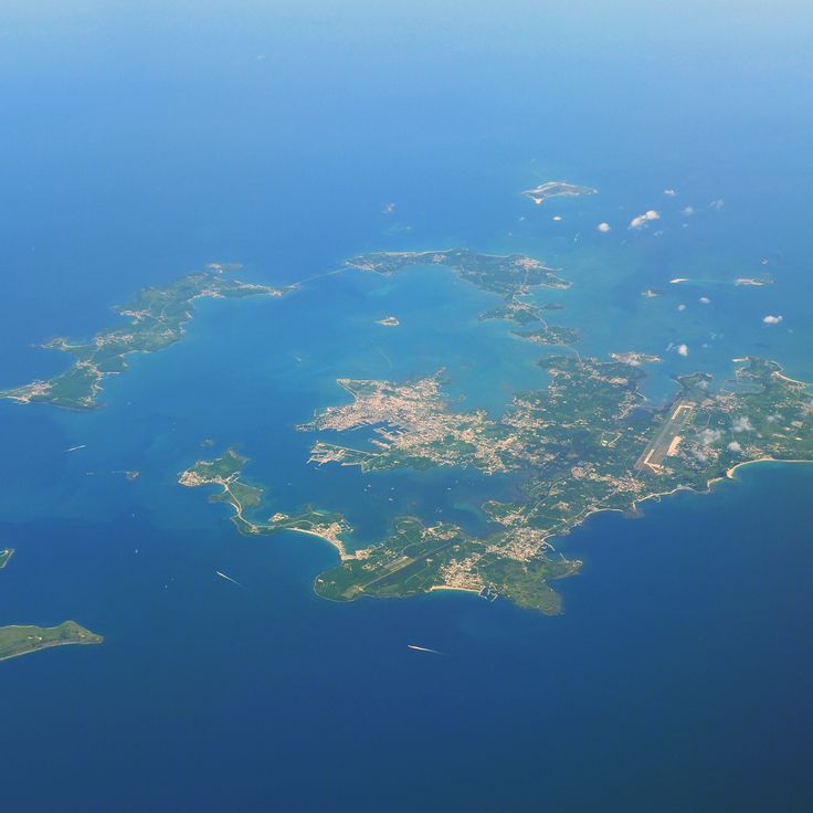
The Strait of Malacca connects the Indian Ocean with the South China Sea and forms one of the busiest waterways in the world for international trade. This passage between the Malay Peninsula and Sumatra allows merchant ships carrying goods between Asia, Europe and the Middle East to pass through. The water here is shallow and the passage narrow, so vessels must navigate slowly and carefully.
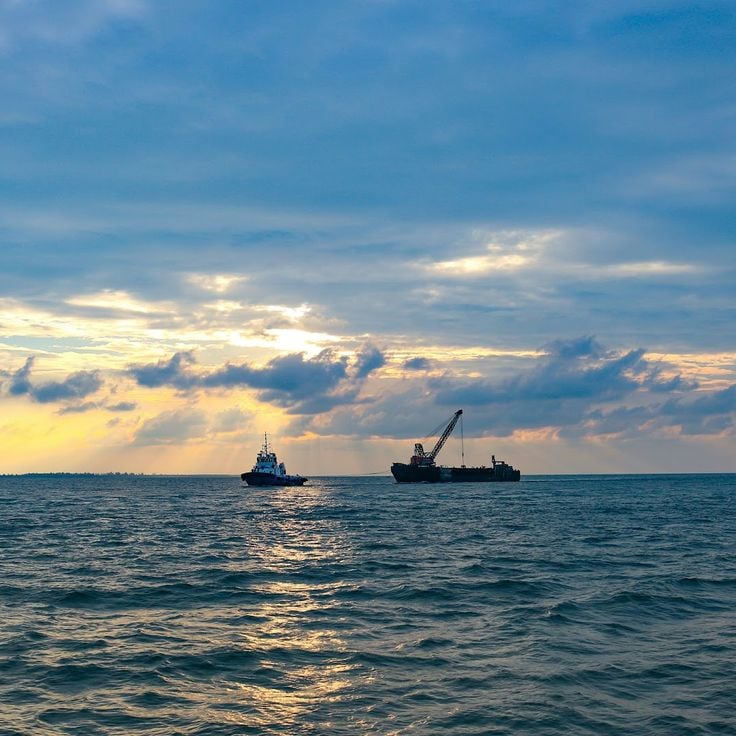
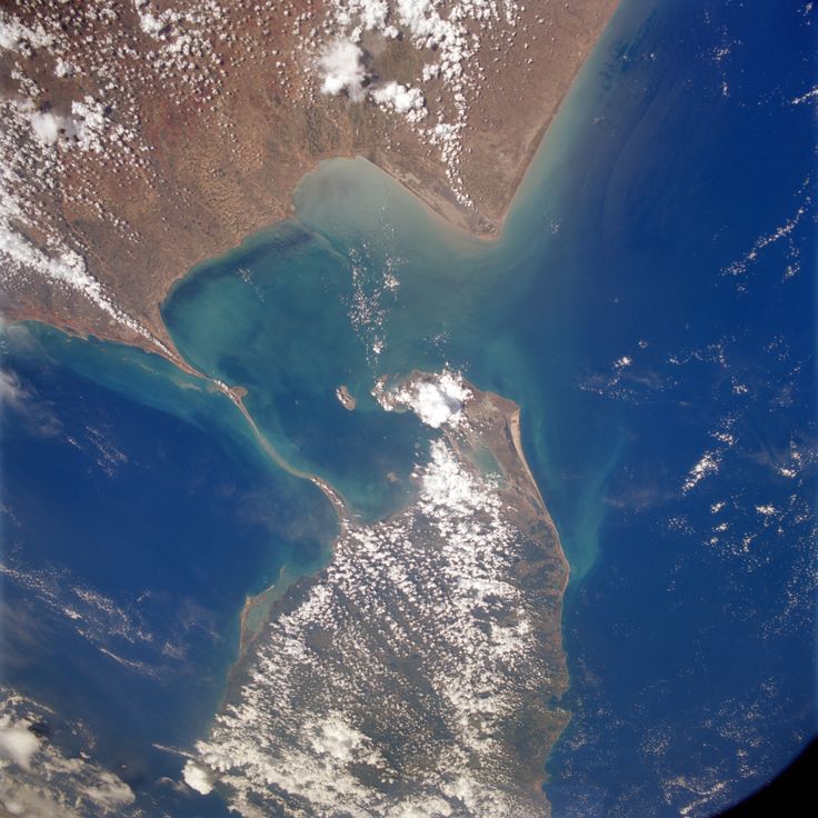
This strait connects the Persian Gulf to the Gulf of Oman, running between the Iranian coast and the Musandam Peninsula. Tankers pass through here on their way between the oil fields of the Gulf and international markets. The water is about 21 miles (33 kilometers) wide at its narrowest point, and the passage follows designated shipping lanes. The shores show rocky cliffs and barren landscapes, while strong currents move through the water. Traffic is heavy, with ships passing through the passage day and night.
The Denmark Strait is a maritime passage roughly 280 kilometers (about 174 miles) wide between Greenland and Iceland. This waterway connects the Greenland Sea to the Irminger Sea and forms part of the navigation routes through the North Atlantic. Cold currents from the Arctic flow south through here, while warmer Atlantic water moves north. The water remains cool throughout the year, and icebergs often drift through the passage. The strait is one of the geographic features that allow water exchange between polar and temperate zones.
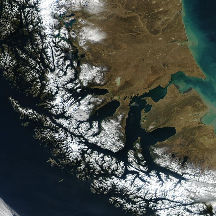
The Strait of Magellan is a waterway that links the Pacific and Atlantic Oceans, running between the South American mainland and Tierra del Fuego. It stretches through Chilean territory and provides a sheltered route for ships seeking to avoid Cape Horn. The passage winds through fjords, channels, and bays, bordered by rugged coasts and mountains. Strong winds and shifting currents shape the waters here. In earlier centuries, it served as a key connection for maritime trade before the Panama Canal opened. Today, cargo vessels and cruise ships still use this historic route, which offers an alternative to the stormy Drake Passage.
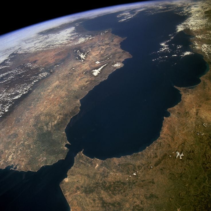
This strait connects the Mediterranean Sea with the Atlantic Ocean and separates Europe from Africa. At its narrowest point, about 14 kilometers (9 miles) of water lie between the two continents. The currents move in two directions: surface water flows from the Atlantic into the Mediterranean, while saltier water at depth takes the opposite path. Rock faces and cliffs rise on both sides, especially on the European shore. Hundreds of cargo ships, ferries, and other vessels pass through here each day. The waters reach depths of around 900 meters (3,000 feet) in some areas. Wind and waves shape the character of this passage, which has served as an important route for trade between Mediterranean lands and the rest of the world for centuries.
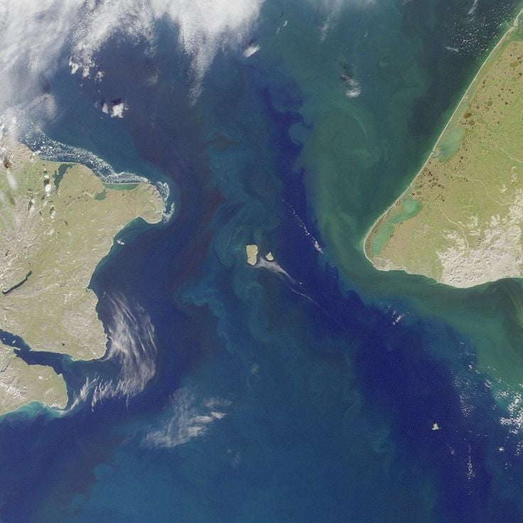
This strait connects the northern Pacific Ocean to the Arctic Ocean and separates the eastern coast of Siberia from Alaska. The Bering Strait is roughly 85 kilometers (53 miles) wide and serves as a natural passage between two continents. In winter, parts of the waterway freeze, which limits navigation. The water is cold and often rough, with strong currents and shifting winds. The passage plays an important role in maritime traffic between the Pacific and the Arctic basin. Ships cross this strait mainly during summer months when ice conditions are more favorable. The region is sparsely populated, with small coastal communities on both sides of the water.
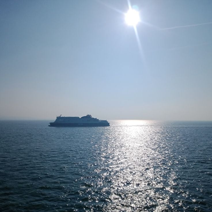
This strait connects the North Sea to the English Channel, separating the French coast near Calais from the white cliffs of Dover on the British side. The water becomes only 21 miles (33 kilometers) wide here, with an average depth of 148 feet (45 meters). Hundreds of cargo ships, ferries, and fishing boats cross the passage in both directions every day, making it one of the busiest shipping routes in the world. On clear days, people can see from one shore to the other. Below the seabed runs the Channel Tunnel, linking France and England.
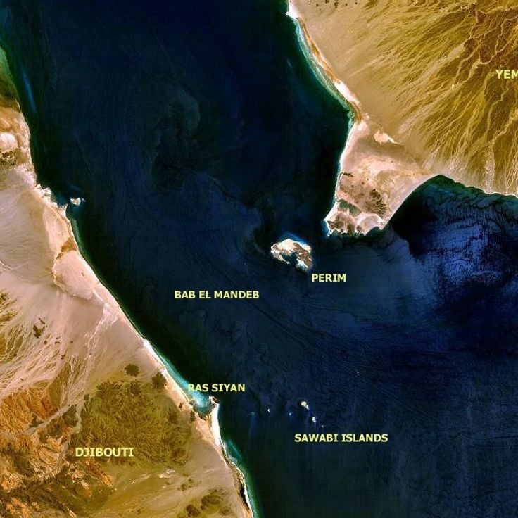
The Bab-el-Mandeb Strait connects the Red Sea with the Gulf of Aden, separating the Arabian Peninsula from the Horn of Africa. This narrow passage is about 20 miles (32 kilometers) wide and serves as a shipping route for cargo vessels traveling between Europe and Asia. Each day, tankers and container ships move through here, carrying oil, goods, and freight. The shores are dry and rocky, with sparse settlements scattered along the coast. The strategic location makes this passage a key corridor for international trade.
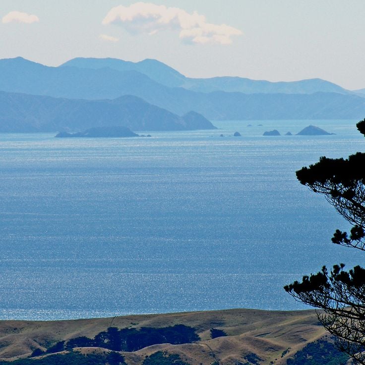
This strait between the North Island and South Island of New Zealand connects the Tasman Sea to the Pacific Ocean and serves as one of the key shipping routes in the southern Pacific. The passage is roughly 14 miles (22 kilometers) wide and known for its strong winds and unpredictable currents, which can make crossing difficult at times. Ferries travel between Wellington and Picton several times a day, carrying passengers, vehicles, and cargo between the two main islands. The surrounding coastline is steep and green, with small bays and rocky outcrops jutting from the water. Fishermen often use these waters, as they are rich in marine life. The Cook Strait is named after the British navigator James Cook, who charted it during the 18th century. For New Zealand's maritime trade and internal connection between the islands, this strait holds great importance.
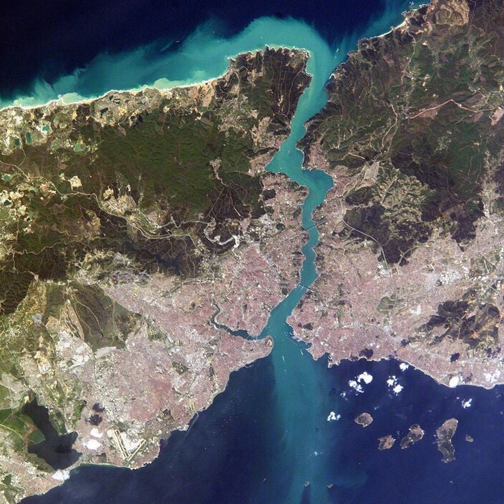
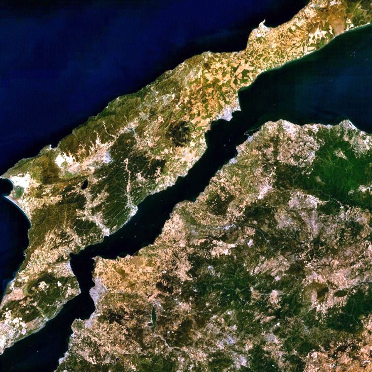
This strait cuts through Istanbul for roughly 19 miles (30 kilometers), separating Europe from Asia. The Bosphorus connects the Black Sea to the Sea of Marmara, forming one of the most important passages for international maritime trade. Along both shores, historic palaces, old fortresses, and residential neighborhoods line the waterway. Ferries shuttle between the two continents throughout the day, while cargo ships from around the world navigate the narrow waters. The current shifts direction depending on depth, making navigation demanding. From the banks, you see mosques, parks, and busy ports that tie urban life to maritime movement.
This strait connects Baffin Bay to the Labrador Sea and forms a body of water roughly 360 kilometers wide (about 220 miles) between Greenland and Baffin Island. The area lies in a region of cold currents and drifting ice, where Arctic waters meet and ecosystems of the far north develop. The passage is marked by high coasts and a sparse landscape that is often covered with ice during the winter months.
This maritime channel in the Indian Ocean separates the eastern coast of Africa from Madagascar across 1600 kilometers. Ocean currents here can reach speeds of 4 knots. As one of the major sea passages in the world, the channel serves as an important shipping route between southern African waters and routes to Asia and the Middle East. Merchant vessels cross this passage regularly, using the natural waterway to transport goods between continents.
This strait connects the Gulf of Mexico to the Atlantic Ocean and lies between the Florida Peninsula and Cuba. Water flows through this natural channel over a distance of about 90 miles (150 kilometers), playing an essential role in ship traffic between North America and Atlantic routes. The Florida Strait sees daily passage of cargo vessels, tankers, and other merchant ships traveling between Gulf region ports and international markets.
The Hudson Strait connects the Atlantic Ocean to Hudson Bay and forms one of the main shipping routes in the Canadian Arctic. This passage separates Baffin Island from the coast of Quebec and extends through cold northern waters. Ships pass through here on their way to ports along Hudson Bay, where trade routes and supply lines meet. The water is covered with ice for most of the year, which limits navigation to short periods in the summer months. Currents are strong, and icebergs drift through the passage, especially during spring and fall. Small communities along the shores depend on this route for supplies and connection to regions farther south. The strait plays a central role in maritime transport and in the history of Arctic exploration.
This strait connects the Arafura Sea to the Coral Sea and runs between the northern tip of Australia and the southern coast of Papua New Guinea. The Torres Strait spans roughly 93 miles (150 kilometers) in width and is dotted with over 270 islands, many of them home to Torres Strait Islander communities. The area is known for its warm, shallow waters, coral reefs, and rich marine biodiversity. Fishing vessels and smaller ships use this passage, while larger commercial ships often prefer the deeper routes east of Australia.
The Sunda Strait is a sea passage between Java and Sumatra that connects the Indian Ocean to the Java Sea. This waterway allows trade and shipping to move between the two bodies of water. It sits in an area with volcanoes, including Krakatau, which erupted in the nineteenth century and changed the geography of the passage. Merchant ships and fishing boats cross it regularly. The water carries currents from both sides, and in some places the passage narrows. The coasts show tropical vegetation, small settlements, and ports that matter for local connections.
The Palk Strait connects the Gulf of Mannar with the Bay of Bengal and separates the southeastern coast of India from Sri Lanka. This waterway measures about 33 miles (53 kilometers) at its widest point and features shallow waters with scattered sandbanks that make passage difficult for larger vessels. Fishing communities from both countries regularly navigate these waters, crossing between the two coasts. Coral reefs and small islands line this corridor, which has served as a traditional route for centuries.
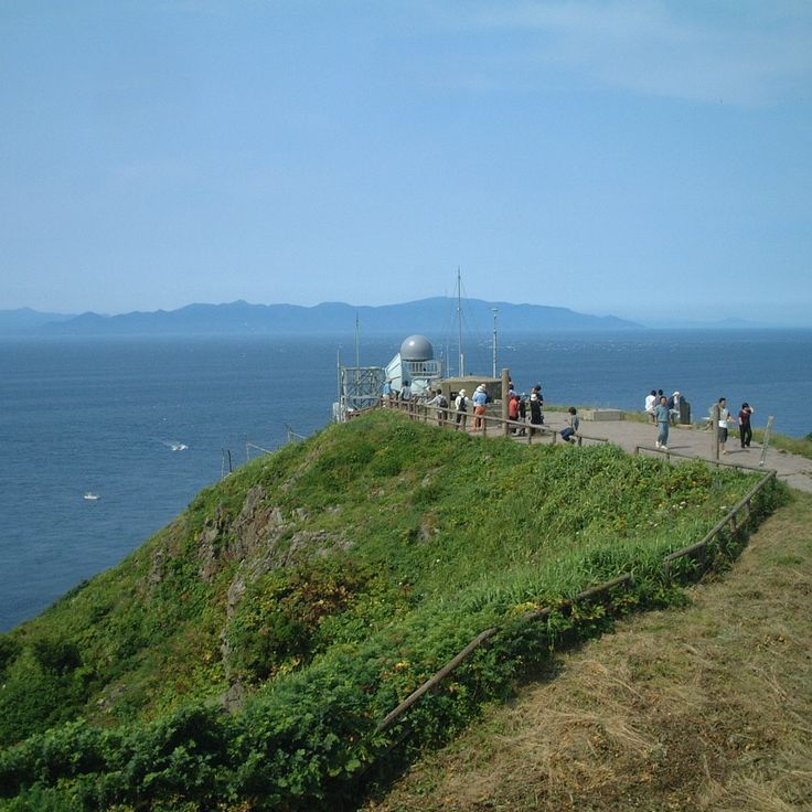
This strait connects the Sea of Japan to the Pacific Ocean and separates the Japanese islands of Honshu and Hokkaido. The Tsugaru Strait serves trade between the two islands and is an important passage for regional shipping. The strait lies in an area where cold currents from the north meet warmer waters from the south, which affects the local climate and fishing. Ferries cross the strait daily, connecting port cities on both sides. In winter, ice floes can appear in the strait, while in summer the waters are calmer and more ships pass through.
This strait runs between the Korean Peninsula and the Japanese islands, connecting the East China Sea to the Sea of Japan. For centuries, it has been an important route for maritime trade between Asia and the Pacific. Cargo ships, freighters, and fishing boats pass through these waters daily, which have played a central role in the history of the region. The currents can be strong, and the weather changes frequently. On clear days, you can see the opposite coast from either shore.
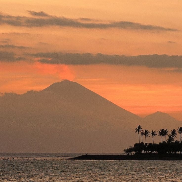
This strait between Bali and Lombok connects the Indian Ocean to the Java Sea and serves as an important waterway for international maritime traffic. The passage lies in a region of volcanic islands and tropical waters, crossed by trade routes and local fishing boats. Deep waters allow larger vessels to pass through as they navigate between oceans.
This strait is a natural waterway linking the Sea of Marmara with the Aegean Sea, separating Europe from Asia. It stretches for 61 kilometers (38 miles) and forms a central part of the trade routes connecting the Black Sea to the Mediterranean. Ships have passed through this historic passage for centuries, and its strategic location makes it a key element in international maritime transport. Currents run strong, and the narrow width of the passage requires careful navigation. Along the shores you see small towns, hills, and coastlines that extend on both sides of the waterway.
The Kattegat is a sea passage between Denmark and Sweden that connects the open waters of the North Sea with the more sheltered area of the Baltic Sea. This passage is 50 to 100 miles wide and forms an important route for merchant ships carrying goods between Northern and Central Europe. The water here is less salty than the North Sea because rivers from the Baltic region bring fresh water in. Small islands dot the area, and coastal towns on both sides live from fishing and shipping. Ferries cross regularly between Danish and Swedish ports, linking communities along the shores.
This body of water lies between Norway and the Danish peninsula of Jutland, forming one of the most important accesses to the Baltic Sea for international maritime transport. The Skagerrak connects the North Sea with the Kattegat and allows merchant ships to pass between Atlantic waters and Baltic ports. The waterway extends across a considerable width and plays a central role in the maritime economy of Northern Europe, as it enables trade routes between Scandinavia and the rest of the continent.
The Strait of Bonifacio is a narrow waterway between Corsica and Sardinia that links the Tyrrhenian Sea to the western Mediterranean. This natural passage between two large Mediterranean islands allows ship traffic and trade routes through the region. The water here moves between steep limestone cliffs and rocky coastlines. Strong currents and shifting winds shape the conditions in this channel. Fishermen from both islands know the waters well and have used them for generations. Ferries cross the strait daily, connecting ports on either side. The passage serves as an important route for boats traveling along Mediterranean coasts. Clear water and rocky surroundings make this strait a notable part of Mediterranean seafaring.
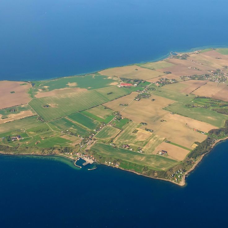
This strait separates the Danish island of Zealand from the Swedish coast of Scania and forms the main connection between the North Sea and the Baltic Sea. The Øresund is about 4 kilometers wide at its narrowest point and broadens to 28 kilometers toward the north. The average water depth is around 10 meters. Densely populated regions lie on both sides of the strait, with Copenhagen on the Danish side and Malmö on the Swedish side, linked by a bridge and tunnel that carry traffic between Scandinavia and continental Europe. The strait is a busy shipping route for trade between the Baltic Sea and the world's oceans.
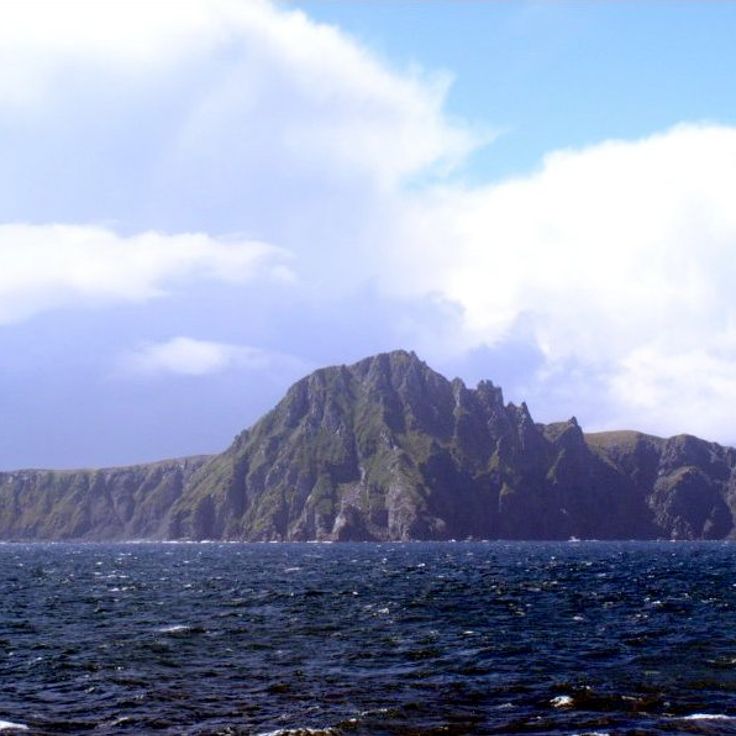
The Drake Passage connects the Atlantic Ocean with the Pacific Ocean and sits between Cape Horn and the South Shetland Islands. This strait separates South America from Antarctica and spans roughly 1000 kilometers (620 miles). The waters are known for their difficult navigation, with strong winds and tall waves formed by the meeting of different ocean currents. Ships cross this route when heading to Antarctica or when sailing around the South American continent.
This strait separates Taiwan from mainland China and connects the South China Sea to the East China Sea. The Taiwan Strait is about 112 miles (180 kilometers) wide and serves as a major shipping lane for international vessels. Merchant ships pass through these waters on routes between ports across East Asia. The passage lies in a region with strong currents and changing weather conditions. Fishermen from both coastal areas have used these waters for centuries. The strait is one of the busiest maritime routes in the world.
This strait connects the South China Sea to the East China Sea, separating Taiwan from mainland China. The Formosa Strait is one of the busiest shipping routes in Asia and serves as a major corridor for trade between ports across East Asia. Cargo ships, tankers, and fishing vessels cross these waters daily. Currents here are strong, and weather conditions shift quickly, especially during typhoon season. Along the coasts lie densely populated areas with ports that serve maritime traffic.
This strait connects the Celebes Sea in the north with the Java Sea in the south, separating the islands of Borneo and Sulawesi over a distance of around 600 kilometers (370 miles). The Makassar Strait serves as a major transport route for oil and commercial goods between Indonesian islands and beyond. Tankers and cargo ships pass through this passage daily on their way to Southeast Asian ports.
The Strait of Malacca connects the Indian Ocean with the South China Sea and forms one of the busiest waterways in the world for international trade. This passage between the Malay Peninsula and Sumatra allows merchant ships carrying goods between Asia, Europe and the Middle East to pass through. The water here is shallow and the passage narrow, so vessels must navigate slowly and carefully.
This strait connects the Persian Gulf to the Gulf of Oman, running between the Iranian coast and the Musandam Peninsula. Tankers pass through here on their way between the oil fields of the Gulf and international markets. The water is about 21 miles (33 kilometers) wide at its narrowest point, and the passage follows designated shipping lanes. The shores show rocky cliffs and barren landscapes, while strong currents move through the water. Traffic is heavy, with ships passing through the passage day and night.
The Denmark Strait is a maritime passage roughly 280 kilometers (about 174 miles) wide between Greenland and Iceland. This waterway connects the Greenland Sea to the Irminger Sea and forms part of the navigation routes through the North Atlantic. Cold currents from the Arctic flow south through here, while warmer Atlantic water moves north. The water remains cool throughout the year, and icebergs often drift through the passage. The strait is one of the geographic features that allow water exchange between polar and temperate zones.
The Strait of Magellan is a waterway that links the Pacific and Atlantic Oceans, running between the South American mainland and Tierra del Fuego. It stretches through Chilean territory and provides a sheltered route for ships seeking to avoid Cape Horn. The passage winds through fjords, channels, and bays, bordered by rugged coasts and mountains. Strong winds and shifting currents shape the waters here. In earlier centuries, it served as a key connection for maritime trade before the Panama Canal opened. Today, cargo vessels and cruise ships still use this historic route, which offers an alternative to the stormy Drake Passage.
This strait connects the Mediterranean Sea with the Atlantic Ocean and separates Europe from Africa. At its narrowest point, about 14 kilometers (9 miles) of water lie between the two continents. The currents move in two directions: surface water flows from the Atlantic into the Mediterranean, while saltier water at depth takes the opposite path. Rock faces and cliffs rise on both sides, especially on the European shore. Hundreds of cargo ships, ferries, and other vessels pass through here each day. The waters reach depths of around 900 meters (3,000 feet) in some areas. Wind and waves shape the character of this passage, which has served as an important route for trade between Mediterranean lands and the rest of the world for centuries.
This strait connects the northern Pacific Ocean to the Arctic Ocean and separates the eastern coast of Siberia from Alaska. The Bering Strait is roughly 85 kilometers (53 miles) wide and serves as a natural passage between two continents. In winter, parts of the waterway freeze, which limits navigation. The water is cold and often rough, with strong currents and shifting winds. The passage plays an important role in maritime traffic between the Pacific and the Arctic basin. Ships cross this strait mainly during summer months when ice conditions are more favorable. The region is sparsely populated, with small coastal communities on both sides of the water.
This strait connects the North Sea to the English Channel, separating the French coast near Calais from the white cliffs of Dover on the British side. The water becomes only 21 miles (33 kilometers) wide here, with an average depth of 148 feet (45 meters). Hundreds of cargo ships, ferries, and fishing boats cross the passage in both directions every day, making it one of the busiest shipping routes in the world. On clear days, people can see from one shore to the other. Below the seabed runs the Channel Tunnel, linking France and England.
The Bab-el-Mandeb Strait connects the Red Sea with the Gulf of Aden, separating the Arabian Peninsula from the Horn of Africa. This narrow passage is about 20 miles (32 kilometers) wide and serves as a shipping route for cargo vessels traveling between Europe and Asia. Each day, tankers and container ships move through here, carrying oil, goods, and freight. The shores are dry and rocky, with sparse settlements scattered along the coast. The strategic location makes this passage a key corridor for international trade.
This strait between the North Island and South Island of New Zealand connects the Tasman Sea to the Pacific Ocean and serves as one of the key shipping routes in the southern Pacific. The passage is roughly 14 miles (22 kilometers) wide and known for its strong winds and unpredictable currents, which can make crossing difficult at times. Ferries travel between Wellington and Picton several times a day, carrying passengers, vehicles, and cargo between the two main islands. The surrounding coastline is steep and green, with small bays and rocky outcrops jutting from the water. Fishermen often use these waters, as they are rich in marine life. The Cook Strait is named after the British navigator James Cook, who charted it during the 18th century. For New Zealand's maritime trade and internal connection between the islands, this strait holds great importance.
This strait cuts through Istanbul for roughly 19 miles (30 kilometers), separating Europe from Asia. The Bosphorus connects the Black Sea to the Sea of Marmara, forming one of the most important passages for international maritime trade. Along both shores, historic palaces, old fortresses, and residential neighborhoods line the waterway. Ferries shuttle between the two continents throughout the day, while cargo ships from around the world navigate the narrow waters. The current shifts direction depending on depth, making navigation demanding. From the banks, you see mosques, parks, and busy ports that tie urban life to maritime movement.
This strait connects Baffin Bay to the Labrador Sea and forms a body of water roughly 360 kilometers wide (about 220 miles) between Greenland and Baffin Island. The area lies in a region of cold currents and drifting ice, where Arctic waters meet and ecosystems of the far north develop. The passage is marked by high coasts and a sparse landscape that is often covered with ice during the winter months.
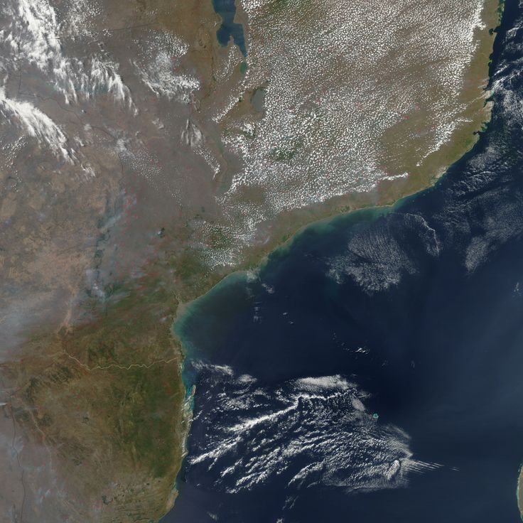
This maritime channel in the Indian Ocean separates the eastern coast of Africa from Madagascar across 1600 kilometers. Ocean currents here can reach speeds of 4 knots. As one of the major sea passages in the world, the channel serves as an important shipping route between southern African waters and routes to Asia and the Middle East. Merchant vessels cross this passage regularly, using the natural waterway to transport goods between continents.
This strait connects the Gulf of Mexico to the Atlantic Ocean and lies between the Florida Peninsula and Cuba. Water flows through this natural channel over a distance of about 90 miles (150 kilometers), playing an essential role in ship traffic between North America and Atlantic routes. The Florida Strait sees daily passage of cargo vessels, tankers, and other merchant ships traveling between Gulf region ports and international markets.
The Hudson Strait connects the Atlantic Ocean to Hudson Bay and forms one of the main shipping routes in the Canadian Arctic. This passage separates Baffin Island from the coast of Quebec and extends through cold northern waters. Ships pass through here on their way to ports along Hudson Bay, where trade routes and supply lines meet. The water is covered with ice for most of the year, which limits navigation to short periods in the summer months. Currents are strong, and icebergs drift through the passage, especially during spring and fall. Small communities along the shores depend on this route for supplies and connection to regions farther south. The strait plays a central role in maritime transport and in the history of Arctic exploration.
This strait connects the Arafura Sea to the Coral Sea and runs between the northern tip of Australia and the southern coast of Papua New Guinea. The Torres Strait spans roughly 93 miles (150 kilometers) in width and is dotted with over 270 islands, many of them home to Torres Strait Islander communities. The area is known for its warm, shallow waters, coral reefs, and rich marine biodiversity. Fishing vessels and smaller ships use this passage, while larger commercial ships often prefer the deeper routes east of Australia.
The Sunda Strait is a sea passage between Java and Sumatra that connects the Indian Ocean to the Java Sea. This waterway allows trade and shipping to move between the two bodies of water. It sits in an area with volcanoes, including Krakatau, which erupted in the nineteenth century and changed the geography of the passage. Merchant ships and fishing boats cross it regularly. The water carries currents from both sides, and in some places the passage narrows. The coasts show tropical vegetation, small settlements, and ports that matter for local connections.
The Palk Strait connects the Gulf of Mannar with the Bay of Bengal and separates the southeastern coast of India from Sri Lanka. This waterway measures about 33 miles (53 kilometers) at its widest point and features shallow waters with scattered sandbanks that make passage difficult for larger vessels. Fishing communities from both countries regularly navigate these waters, crossing between the two coasts. Coral reefs and small islands line this corridor, which has served as a traditional route for centuries.
This strait connects the Sea of Japan to the Pacific Ocean and separates the Japanese islands of Honshu and Hokkaido. The Tsugaru Strait serves trade between the two islands and is an important passage for regional shipping. The strait lies in an area where cold currents from the north meet warmer waters from the south, which affects the local climate and fishing. Ferries cross the strait daily, connecting port cities on both sides. In winter, ice floes can appear in the strait, while in summer the waters are calmer and more ships pass through.
This strait runs between the Korean Peninsula and the Japanese islands, connecting the East China Sea to the Sea of Japan. For centuries, it has been an important route for maritime trade between Asia and the Pacific. Cargo ships, freighters, and fishing boats pass through these waters daily, which have played a central role in the history of the region. The currents can be strong, and the weather changes frequently. On clear days, you can see the opposite coast from either shore.
This strait between Bali and Lombok connects the Indian Ocean to the Java Sea and serves as an important waterway for international maritime traffic. The passage lies in a region of volcanic islands and tropical waters, crossed by trade routes and local fishing boats. Deep waters allow larger vessels to pass through as they navigate between oceans.
This strait is a natural waterway linking the Sea of Marmara with the Aegean Sea, separating Europe from Asia. It stretches for 61 kilometers (38 miles) and forms a central part of the trade routes connecting the Black Sea to the Mediterranean. Ships have passed through this historic passage for centuries, and its strategic location makes it a key element in international maritime transport. Currents run strong, and the narrow width of the passage requires careful navigation. Along the shores you see small towns, hills, and coastlines that extend on both sides of the waterway.
The Kattegat is a sea passage between Denmark and Sweden that connects the open waters of the North Sea with the more sheltered area of the Baltic Sea. This passage is 50 to 100 miles wide and forms an important route for merchant ships carrying goods between Northern and Central Europe. The water here is less salty than the North Sea because rivers from the Baltic region bring fresh water in. Small islands dot the area, and coastal towns on both sides live from fishing and shipping. Ferries cross regularly between Danish and Swedish ports, linking communities along the shores.
This body of water lies between Norway and the Danish peninsula of Jutland, forming one of the most important accesses to the Baltic Sea for international maritime transport. The Skagerrak connects the North Sea with the Kattegat and allows merchant ships to pass between Atlantic waters and Baltic ports. The waterway extends across a considerable width and plays a central role in the maritime economy of Northern Europe, as it enables trade routes between Scandinavia and the rest of the continent.
The Strait of Bonifacio is a narrow waterway between Corsica and Sardinia that links the Tyrrhenian Sea to the western Mediterranean. This natural passage between two large Mediterranean islands allows ship traffic and trade routes through the region. The water here moves between steep limestone cliffs and rocky coastlines. Strong currents and shifting winds shape the conditions in this channel. Fishermen from both islands know the waters well and have used them for generations. Ferries cross the strait daily, connecting ports on either side. The passage serves as an important route for boats traveling along Mediterranean coasts. Clear water and rocky surroundings make this strait a notable part of Mediterranean seafaring.
This strait separates the Danish island of Zealand from the Swedish coast of Scania and forms the main connection between the North Sea and the Baltic Sea. The Øresund is about 4 kilometers wide at its narrowest point and broadens to 28 kilometers toward the north. The average water depth is around 10 meters. Densely populated regions lie on both sides of the strait, with Copenhagen on the Danish side and Malmö on the Swedish side, linked by a bridge and tunnel that carry traffic between Scandinavia and continental Europe. The strait is a busy shipping route for trade between the Baltic Sea and the world's oceans.
The Drake Passage connects the Atlantic Ocean with the Pacific Ocean and sits between Cape Horn and the South Shetland Islands. This strait separates South America from Antarctica and spans roughly 1000 kilometers (620 miles). The waters are known for their difficult navigation, with strong winds and tall waves formed by the meeting of different ocean currents. Ships cross this route when heading to Antarctica or when sailing around the South American continent.
This strait separates Taiwan from mainland China and connects the South China Sea to the East China Sea. The Taiwan Strait is about 112 miles (180 kilometers) wide and serves as a major shipping lane for international vessels. Merchant ships pass through these waters on routes between ports across East Asia. The passage lies in a region with strong currents and changing weather conditions. Fishermen from both coastal areas have used these waters for centuries. The strait is one of the busiest maritime routes in the world.
This strait connects the South China Sea to the East China Sea, separating Taiwan from mainland China. The Formosa Strait is one of the busiest shipping routes in Asia and serves as a major corridor for trade between ports across East Asia. Cargo ships, tankers, and fishing vessels cross these waters daily. Currents here are strong, and weather conditions shift quickly, especially during typhoon season. Along the coasts lie densely populated areas with ports that serve maritime traffic.
This strait connects the Celebes Sea in the north with the Java Sea in the south, separating the islands of Borneo and Sulawesi over a distance of around 600 kilometers (370 miles). The Makassar Strait serves as a major transport route for oil and commercial goods between Indonesian islands and beyond. Tankers and cargo ships pass through this passage daily on their way to Southeast Asian ports.
The Strait of Malacca connects the Indian Ocean with the South China Sea and forms one of the busiest waterways in the world for international trade. This passage between the Malay Peninsula and Sumatra allows merchant ships carrying goods between Asia, Europe and the Middle East to pass through. The water here is shallow and the passage narrow, so vessels must navigate slowly and carefully.
This strait connects the Persian Gulf to the Gulf of Oman, running between the Iranian coast and the Musandam Peninsula. Tankers pass through here on their way between the oil fields of the Gulf and international markets. The water is about 21 miles (33 kilometers) wide at its narrowest point, and the passage follows designated shipping lanes. The shores show rocky cliffs and barren landscapes, while strong currents move through the water. Traffic is heavy, with ships passing through the passage day and night.
The Denmark Strait is a maritime passage roughly 280 kilometers (about 174 miles) wide between Greenland and Iceland. This waterway connects the Greenland Sea to the Irminger Sea and forms part of the navigation routes through the North Atlantic. Cold currents from the Arctic flow south through here, while warmer Atlantic water moves north. The water remains cool throughout the year, and icebergs often drift through the passage. The strait is one of the geographic features that allow water exchange between polar and temperate zones.
The Strait of Magellan is a waterway that links the Pacific and Atlantic Oceans, running between the South American mainland and Tierra del Fuego. It stretches through Chilean territory and provides a sheltered route for ships seeking to avoid Cape Horn. The passage winds through fjords, channels, and bays, bordered by rugged coasts and mountains. Strong winds and shifting currents shape the waters here. In earlier centuries, it served as a key connection for maritime trade before the Panama Canal opened. Today, cargo vessels and cruise ships still use this historic route, which offers an alternative to the stormy Drake Passage.
This strait connects the Mediterranean Sea with the Atlantic Ocean and separates Europe from Africa. At its narrowest point, about 14 kilometers (9 miles) of water lie between the two continents. The currents move in two directions: surface water flows from the Atlantic into the Mediterranean, while saltier water at depth takes the opposite path. Rock faces and cliffs rise on both sides, especially on the European shore. Hundreds of cargo ships, ferries, and other vessels pass through here each day. The waters reach depths of around 900 meters (3,000 feet) in some areas. Wind and waves shape the character of this passage, which has served as an important route for trade between Mediterranean lands and the rest of the world for centuries.
This strait connects the northern Pacific Ocean to the Arctic Ocean and separates the eastern coast of Siberia from Alaska. The Bering Strait is roughly 85 kilometers (53 miles) wide and serves as a natural passage between two continents. In winter, parts of the waterway freeze, which limits navigation. The water is cold and often rough, with strong currents and shifting winds. The passage plays an important role in maritime traffic between the Pacific and the Arctic basin. Ships cross this strait mainly during summer months when ice conditions are more favorable. The region is sparsely populated, with small coastal communities on both sides of the water.
This strait connects the North Sea to the English Channel, separating the French coast near Calais from the white cliffs of Dover on the British side. The water becomes only 21 miles (33 kilometers) wide here, with an average depth of 148 feet (45 meters). Hundreds of cargo ships, ferries, and fishing boats cross the passage in both directions every day, making it one of the busiest shipping routes in the world. On clear days, people can see from one shore to the other. Below the seabed runs the Channel Tunnel, linking France and England.
The Bab-el-Mandeb Strait connects the Red Sea with the Gulf of Aden, separating the Arabian Peninsula from the Horn of Africa. This narrow passage is about 20 miles (32 kilometers) wide and serves as a shipping route for cargo vessels traveling between Europe and Asia. Each day, tankers and container ships move through here, carrying oil, goods, and freight. The shores are dry and rocky, with sparse settlements scattered along the coast. The strategic location makes this passage a key corridor for international trade.
This strait between the North Island and South Island of New Zealand connects the Tasman Sea to the Pacific Ocean and serves as one of the key shipping routes in the southern Pacific. The passage is roughly 14 miles (22 kilometers) wide and known for its strong winds and unpredictable currents, which can make crossing difficult at times. Ferries travel between Wellington and Picton several times a day, carrying passengers, vehicles, and cargo between the two main islands. The surrounding coastline is steep and green, with small bays and rocky outcrops jutting from the water. Fishermen often use these waters, as they are rich in marine life. The Cook Strait is named after the British navigator James Cook, who charted it during the 18th century. For New Zealand's maritime trade and internal connection between the islands, this strait holds great importance.
This strait cuts through Istanbul for roughly 19 miles (30 kilometers), separating Europe from Asia. The Bosphorus connects the Black Sea to the Sea of Marmara, forming one of the most important passages for international maritime trade. Along both shores, historic palaces, old fortresses, and residential neighborhoods line the waterway. Ferries shuttle between the two continents throughout the day, while cargo ships from around the world navigate the narrow waters. The current shifts direction depending on depth, making navigation demanding. From the banks, you see mosques, parks, and busy ports that tie urban life to maritime movement.
This strait connects Baffin Bay to the Labrador Sea and forms a body of water roughly 360 kilometers wide (about 220 miles) between Greenland and Baffin Island. The area lies in a region of cold currents and drifting ice, where Arctic waters meet and ecosystems of the far north develop. The passage is marked by high coasts and a sparse landscape that is often covered with ice during the winter months.
This maritime channel in the Indian Ocean separates the eastern coast of Africa from Madagascar across 1600 kilometers. Ocean currents here can reach speeds of 4 knots. As one of the major sea passages in the world, the channel serves as an important shipping route between southern African waters and routes to Asia and the Middle East. Merchant vessels cross this passage regularly, using the natural waterway to transport goods between continents.
This strait connects the Gulf of Mexico to the Atlantic Ocean and lies between the Florida Peninsula and Cuba. Water flows through this natural channel over a distance of about 90 miles (150 kilometers), playing an essential role in ship traffic between North America and Atlantic routes. The Florida Strait sees daily passage of cargo vessels, tankers, and other merchant ships traveling between Gulf region ports and international markets.
The Hudson Strait connects the Atlantic Ocean to Hudson Bay and forms one of the main shipping routes in the Canadian Arctic. This passage separates Baffin Island from the coast of Quebec and extends through cold northern waters. Ships pass through here on their way to ports along Hudson Bay, where trade routes and supply lines meet. The water is covered with ice for most of the year, which limits navigation to short periods in the summer months. Currents are strong, and icebergs drift through the passage, especially during spring and fall. Small communities along the shores depend on this route for supplies and connection to regions farther south. The strait plays a central role in maritime transport and in the history of Arctic exploration.
This strait connects the Arafura Sea to the Coral Sea and runs between the northern tip of Australia and the southern coast of Papua New Guinea. The Torres Strait spans roughly 93 miles (150 kilometers) in width and is dotted with over 270 islands, many of them home to Torres Strait Islander communities. The area is known for its warm, shallow waters, coral reefs, and rich marine biodiversity. Fishing vessels and smaller ships use this passage, while larger commercial ships often prefer the deeper routes east of Australia.
The Sunda Strait is a sea passage between Java and Sumatra that connects the Indian Ocean to the Java Sea. This waterway allows trade and shipping to move between the two bodies of water. It sits in an area with volcanoes, including Krakatau, which erupted in the nineteenth century and changed the geography of the passage. Merchant ships and fishing boats cross it regularly. The water carries currents from both sides, and in some places the passage narrows. The coasts show tropical vegetation, small settlements, and ports that matter for local connections.
The Palk Strait connects the Gulf of Mannar with the Bay of Bengal and separates the southeastern coast of India from Sri Lanka. This waterway measures about 33 miles (53 kilometers) at its widest point and features shallow waters with scattered sandbanks that make passage difficult for larger vessels. Fishing communities from both countries regularly navigate these waters, crossing between the two coasts. Coral reefs and small islands line this corridor, which has served as a traditional route for centuries.
This strait connects the Sea of Japan to the Pacific Ocean and separates the Japanese islands of Honshu and Hokkaido. The Tsugaru Strait serves trade between the two islands and is an important passage for regional shipping. The strait lies in an area where cold currents from the north meet warmer waters from the south, which affects the local climate and fishing. Ferries cross the strait daily, connecting port cities on both sides. In winter, ice floes can appear in the strait, while in summer the waters are calmer and more ships pass through.
This strait runs between the Korean Peninsula and the Japanese islands, connecting the East China Sea to the Sea of Japan. For centuries, it has been an important route for maritime trade between Asia and the Pacific. Cargo ships, freighters, and fishing boats pass through these waters daily, which have played a central role in the history of the region. The currents can be strong, and the weather changes frequently. On clear days, you can see the opposite coast from either shore.
This strait between Bali and Lombok connects the Indian Ocean to the Java Sea and serves as an important waterway for international maritime traffic. The passage lies in a region of volcanic islands and tropical waters, crossed by trade routes and local fishing boats. Deep waters allow larger vessels to pass through as they navigate between oceans.
This strait is a natural waterway linking the Sea of Marmara with the Aegean Sea, separating Europe from Asia. It stretches for 61 kilometers (38 miles) and forms a central part of the trade routes connecting the Black Sea to the Mediterranean. Ships have passed through this historic passage for centuries, and its strategic location makes it a key element in international maritime transport. Currents run strong, and the narrow width of the passage requires careful navigation. Along the shores you see small towns, hills, and coastlines that extend on both sides of the waterway.
The Kattegat is a sea passage between Denmark and Sweden that connects the open waters of the North Sea with the more sheltered area of the Baltic Sea. This passage is 50 to 100 miles wide and forms an important route for merchant ships carrying goods between Northern and Central Europe. The water here is less salty than the North Sea because rivers from the Baltic region bring fresh water in. Small islands dot the area, and coastal towns on both sides live from fishing and shipping. Ferries cross regularly between Danish and Swedish ports, linking communities along the shores.
This body of water lies between Norway and the Danish peninsula of Jutland, forming one of the most important accesses to the Baltic Sea for international maritime transport. The Skagerrak connects the North Sea with the Kattegat and allows merchant ships to pass between Atlantic waters and Baltic ports. The waterway extends across a considerable width and plays a central role in the maritime economy of Northern Europe, as it enables trade routes between Scandinavia and the rest of the continent.
The Strait of Bonifacio is a narrow waterway between Corsica and Sardinia that links the Tyrrhenian Sea to the western Mediterranean. This natural passage between two large Mediterranean islands allows ship traffic and trade routes through the region. The water here moves between steep limestone cliffs and rocky coastlines. Strong currents and shifting winds shape the conditions in this channel. Fishermen from both islands know the waters well and have used them for generations. Ferries cross the strait daily, connecting ports on either side. The passage serves as an important route for boats traveling along Mediterranean coasts. Clear water and rocky surroundings make this strait a notable part of Mediterranean seafaring.
This strait separates the Danish island of Zealand from the Swedish coast of Scania and forms the main connection between the North Sea and the Baltic Sea. The Øresund is about 4 kilometers wide at its narrowest point and broadens to 28 kilometers toward the north. The average water depth is around 10 meters. Densely populated regions lie on both sides of the strait, with Copenhagen on the Danish side and Malmö on the Swedish side, linked by a bridge and tunnel that carry traffic between Scandinavia and continental Europe. The strait is a busy shipping route for trade between the Baltic Sea and the world's oceans.
The Drake Passage connects the Atlantic Ocean with the Pacific Ocean and sits between Cape Horn and the South Shetland Islands. This strait separates South America from Antarctica and spans roughly 1000 kilometers (620 miles). The waters are known for their difficult navigation, with strong winds and tall waves formed by the meeting of different ocean currents. Ships cross this route when heading to Antarctica or when sailing around the South American continent.
This strait separates Taiwan from mainland China and connects the South China Sea to the East China Sea. The Taiwan Strait is about 112 miles (180 kilometers) wide and serves as a major shipping lane for international vessels. Merchant ships pass through these waters on routes between ports across East Asia. The passage lies in a region with strong currents and changing weather conditions. Fishermen from both coastal areas have used these waters for centuries. The strait is one of the busiest maritime routes in the world.
This strait connects the South China Sea to the East China Sea, separating Taiwan from mainland China. The Formosa Strait is one of the busiest shipping routes in Asia and serves as a major corridor for trade between ports across East Asia. Cargo ships, tankers, and fishing vessels cross these waters daily. Currents here are strong, and weather conditions shift quickly, especially during typhoon season. Along the coasts lie densely populated areas with ports that serve maritime traffic.
This strait connects the Celebes Sea in the north with the Java Sea in the south, separating the islands of Borneo and Sulawesi over a distance of around 600 kilometers (370 miles). The Makassar Strait serves as a major transport route for oil and commercial goods between Indonesian islands and beyond. Tankers and cargo ships pass through this passage daily on their way to Southeast Asian ports.