Chest opened
+${chestReward.xp} XP
Explorer
NOUVEAU ×${chestReward.collectible.quantity}
tapez pour fermer
Chest locked

Open chests in the app

Around Us is built for your phone — chests unlock when you walk, explore and capture nearby places.

Enable Location

We need your location to show you interesting places around you

Discover nearby places

Find interesting locations and hidden gems around you

Precise directions

Get accurate directions and distances to places

Your location is never shared with other users. It's only used when you tap the location button.

Caltrain

Log in to your account

Start exploring — it's free

Trusted by 72,886 travelers worldwide

Continue with Google
Continue with Apple
or

We will send you a code to connect

By continuing, you accept our Terms and Conditions and our Privacy Policy

Check your inbox

We've sent a pincode in your inbox. Please enter the code below.

Discussion Reviews 2 Photos
102k Popularity

Caltrain, Public transport network in San Francisco Bay Area, US.

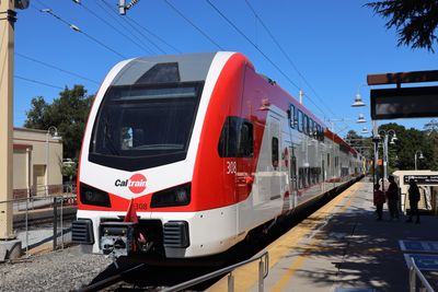
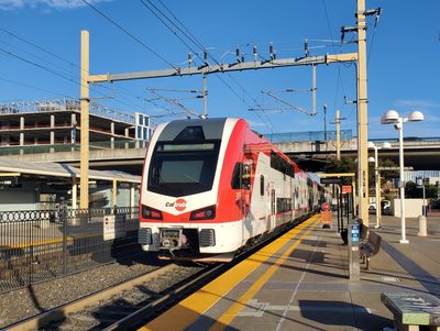
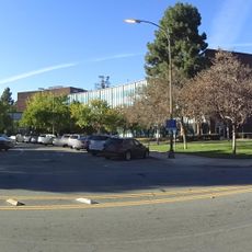
Caltrain is a commuter train that runs 77 miles (124 kilometers) between San Francisco and Gilroy on the peninsula south of the bay. The train stops at 32 stations, many of them in city centers like Palo Alto, San José, and Millbrae.

The state of California purchased the rail line from Southern Pacific Railway in 1985 and began operating it as a public commuter system two years later. Since 2024, electric trains run the entire route between San Francisco and San José, which previously used diesel locomotives.

The train brings commuters to technology companies in Palo Alto and Mountain View, while on weekends families ride to baseball stadiums in San Francisco or beaches in San Mateo. Along the route you see riders carrying bicycles, surfboards, or backpacks who use the system for recreation.

Tickets can be purchased at machines on every platform, with the price depending on the distance between your starting and ending station. Trains run more frequently on weekdays than weekends, and travelers should check schedules ahead of time at smaller stations.

Every train has special cars with racks that hold dozens of bicycles, allowing commuters to combine both modes of transport for their daily trip. At some stations you can watch cyclists roll their bikes directly onto the platform and into marked areas in the train.

The community of curious travelers

AroundUs brings together thousands of curated places, local tips, and hidden gems, enriched daily by 60,000 contributors worldwide.

Start exploring
Location
Location
Inception
1985
Official opening
1987
Operator
TransitAmerica Services, Incorporated
Part of
public transportation in San Francisco
Address
Lenzen Avenue
GPS coordinates
37.33878,-121.90765
Latest update
December 12, 2025 23:19
Around this place
Rosicrucian Egyptian Museum
United States of America

Rosicrucian Egyptian Museum

1.5 km
San Jose Diridon station
United States of America

San Jose Diridon station

1.1 km
Christmas in the Park
United States of America

Christmas in the Park

1.7 km
San Jose Center for the Performing Arts
United States of America

San Jose Center for the Performing Arts

1.7 km
San Jose Museum of Art
United States of America

San Jose Museum of Art

1.7 km
Rosicrucian Park
United States of America

Rosicrucian Park

1.5 km
Hotel De Anza
United States of America

Hotel De Anza

1.2 km
San Jose Municipal Rose Garden
United States of America

San Jose Municipal Rose Garden

1.9 km
Plaza de César Chávez
United States of America

Plaza de César Chávez

1.7 km
Peralta Adobe
United States of America

Peralta Adobe

1.2 km
Cathedral Basilica of Saint Joseph
United States of America

Cathedral Basilica of Saint Joseph

1.6 km
Circle of Palms Plaza
United States of America

Circle of Palms Plaza

1.7 km
Bank of Italy Building
United States of America

Bank of Italy Building

1.6 km
Japanese American Museum of San Jose
United States of America

Japanese American Museum of San Jose

1.6 km
Chinatown in San Jose
United States of America

Chinatown in San Jose

909 m
Hensley Historic District, San Jose
United States of America

Hensley Historic District, San Jose

1.4 km
Trinity Cathedral
United States of America

Trinity Cathedral

1.5 km
The First Unitarian Church of San José
United States of America

The First Unitarian Church of San José

1.6 km
Tower 55
United States of America

Tower 55

1.5 km
Fairmont Plaza
United States of America

Fairmont Plaza

1.7 km
Leib Carriage House
United States of America

Leib Carriage House

638 m
Gravestone of Harvey Spencer Lewis
United States of America

Gravestone of Harvey Spencer Lewis

1.5 km
Old Santa Clara County Courthouse
United States of America

Old Santa Clara County Courthouse

1.3 km
Captain Thomas Fallon
United States of America

Captain Thomas Fallon

985 m
Taylor Street Urban Interchange
United States of America

Taylor Street Urban Interchange

886 m
Santa Clara County Government Center
United States of America

Santa Clara County Government Center

1.5 km
San Jose City Hall
United States of America

San Jose City Hall

1.4 km
San Jose City Hall
United States of America

San Jose City Hall

1.7 km
Show the full map
Reviews
Share your experience

No review yet

Discussions
Start a discussion...

No discussion yet

« Caltrain - Public transport network in San Francisco Bay Area, US » is provided by Around Us (aroundus.com). Images and texts are derived from Wikimedia project under a Creative Commons license. You are allowed to copy, distribute, and modify copies of this page, under the conditions set by the license, as long as this note is clearly visible.

Discover hidden gems everywhere you go!

From secret cafés to breathtaking viewpoints, skip the crowded tourist spots and find places that match your style. Our app makes it easy with voice search, smart filtering, route optimization, and insider tips from travelers worldwide. Download now for the complete mobile experience.

Around Us App Screenshot

A unique approach to discovering new places

Le Figaro

All the places worth exploring

France Info

A tailor-made excursion in just a few clicks

20 Minutes

Around Us
Travel Guide & Maps
Download

Send to your phone

QR Code
1

Open the camera app on your mobile.

2

Point at the QR code with your camera. A notification will appear.

3

Tap the notification to open the link.