Enable Location

We need your location to show you interesting places around you

Discover nearby places

Find interesting locations and hidden gems around you

Precise directions

Get accurate directions and distances to places

Your location is never shared with other users. It's only used when you tap the location button.

Hell Creek Formation

Log in to your account

Start exploring — it's free

Trusted by 61,912 travelers worldwide

Continue with Google
Continue with Apple
or

We will send you a code to connect

By continuing, you accept our Terms and Conditions and our Privacy Policy

Check your inbox

We've sent a pincode in your inbox. Please enter the code below.

Hell Creek Formation

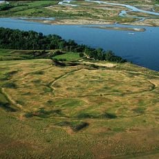
Hell Creek Formation, Geological formation in western North Dakota, United States.

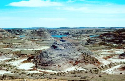
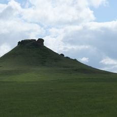
The Hell Creek Formation is a series of sandstone and clay layers in western North Dakota that rises through about 560 feet of rock dating from the Upper Cretaceous period. The layers appear exposed at the surface and display colors ranging from gray to brown and reddish, with alternating harder and softer rock bands.

Paleontologist Barnum Brown first documented this formation in 1907 and recognized its value for studying the final chapter of the dinosaur age. The rocks formed between roughly 66 and 68 million years ago in a low coastal plain that later rose to become part of today's Great Plains.

The formation houses extensive collections at the Museum of the Rockies and University of California Museum of Paleontology, contributing to scientific education.

Visitors should obtain permits from the relevant land management agencies before collecting fossils or removing rock samples. Any finds should be reported so that scientists can receive valuable information about location and context.

The formation contains the K-Pg boundary, a thin layer of clay and iridium that marks the transition between the Cretaceous period and the Paleogene. This line shows the moment when an asteroid impact fundamentally changed life on Earth.

The community of curious travelers

AroundUs brings together thousands of curated places, local tips, and hidden gems, enriched daily by 60,000 contributors worldwide.

Start exploring
Location
GPS coordinates
46.90000,-101.50000
Latest update
December 13, 2025 15:57
Around this place
Fort Abraham Lincoln
United States of America

Fort Abraham Lincoln

51.8 km
Fort Mandan
United States of America

Fort Mandan

47 km
North Dakota Governor's Residence
United States of America

North Dakota Governor's Residence

55.2 km
Salem Sue
United States of America

Salem Sue

7.7 km
Dakota Zoo
United States of America

Dakota Zoo

53.9 km
Bismarck North Dakota Temple
United States of America

Bismarck North Dakota Temple

52.6 km
Fort Clark Trading Post State Historic Site
United States of America

Fort Clark Trading Post State Historic Site

42.7 km
Cross Ranch State Park
United States of America

Cross Ranch State Park

51.6 km
Cathedral of the Holy Spirit
United States of America

Cathedral of the Holy Spirit

54.5 km
Heart Butte Dam
United States of America

Heart Butte Dam

41.2 km
Double Ditch
United States of America

Double Ditch

45.7 km
Liberty Memorial Bridge
United States of America

Liberty Memorial Bridge

52 km
Former North Dakota Executive Mansion
United States of America

Former North Dakota Executive Mansion

55.2 km
Fred Krause House
United States of America

Fred Krause House

44.9 km
Camp Hancock State Historic Site
United States of America

Camp Hancock State Historic Site

54.9 km
Hotel Brown
United States of America

Hotel Brown

53.7 km
German Evangelical St. Johns Church
United States of America

German Evangelical St. Johns Church

41.6 km
Bismarck Cathedral Area Historic District
United States of America

Bismarck Cathedral Area Historic District

54.5 km
Chief Looking's Village site
United States of America

Chief Looking's Village site

51.7 km
Carson Roller Mill
United States of America

Carson Roller Mill

53.8 km
Missouri River High Bridge
United States of America

Missouri River High Bridge

52 km
Fred and Gladys Grady House
United States of America

Fred and Gladys Grady House

55.3 km
Raging Rivers
United States of America

Raging Rivers

52.3 km
SuperSlide Amusement Park
United States of America

SuperSlide Amusement Park

53.9 km
Sims Lutheran Church
United States of America

Sims Lutheran Church

14.2 km
Former Governors' Mansion State Historic Site
United States of America

Former Governors' Mansion State Historic Site

55.2 km
Camp Hancock State Historic Site
United States of America

Camp Hancock State Historic Site

55 km
Louis Rehm Barn
United States of America

Louis Rehm Barn

42.9 km
Show the full map
« Hell Creek Formation - Geological formation in western North Dakota, United States » is provided by Around Us (aroundus.com). Images and texts are derived from Wikimedia project under a Creative Commons license. You are allowed to copy, distribute, and modify copies of this page, under the conditions set by the license, as long as this note is clearly visible.

Discover hidden gems everywhere you go!

From secret cafés to breathtaking viewpoints, skip the crowded tourist spots and find places that match your style. Our app makes it easy with voice search, smart filtering, route optimization, and insider tips from travelers worldwide. Download now for the complete mobile experience.

Around Us App Screenshot

A unique approach to discovering new places

Le Figaro

All the places worth exploring

France Info

A tailor-made excursion in just a few clicks

20 Minutes

Around Us
Travel Guide & Maps
Download

Send to your phone

QR Code
1

Open the camera app on your mobile.

2

Point at the QR code with your camera. A notification will appear.

3

Tap the notification to open the link.