Enable Location

We need your location to show you interesting places around you

Discover nearby places

Find interesting locations and hidden gems around you

Precise directions

Get accurate directions and distances to places

Your location is never shared with other users. It's only used when you tap the location button.

Log in to your account

Start exploring — it's free

Trusted by 66,096 travelers worldwide

Continue with Google
Continue with Apple
or

We will send you a code to connect

By continuing, you accept our Terms and Conditions and our Privacy Policy

Check your inbox

We've sent a pincode in your inbox. Please enter the code below.

Fort Lisa
Discussion Reviews Photo
5.3k Popularity

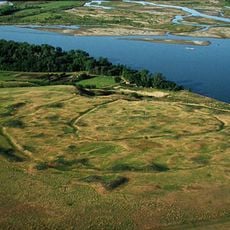
Fort Lisa, Trading fort near Missouri River, North Dakota

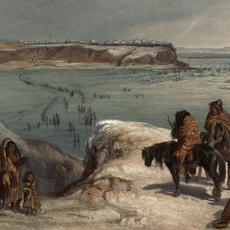
Fort Lisa is a historic fur trading post in North Dakota, built as a square two-story blockhouse at the junction of two rivers. The lower floor was used to store furs, while the upper floor provided basic shelter for the traders and hunters who passed through.

Manuel Lisa established this post in 1809 on behalf of the Missouri Fur Company to gain access to fur trade routes in the northern territories. The site was chosen for its position where two rivers meet, which made moving goods by canoe faster and easier.

Fort Lisa brought together fur traders from the east and Hidatsa people from the surrounding lands to exchange goods. Each group brought different knowledge of the land and its resources, making the post a crossroads of two worlds.

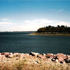
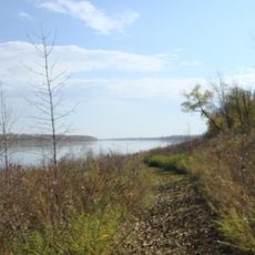
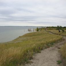
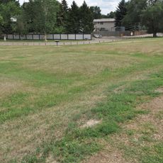
The site sits near the water, so the ground can be soft and wet, especially after rain or during spring. Sturdy shoes are a good idea, and early morning visits tend to offer more comfortable conditions.

Sacagawea, the guide from the Lewis and Clark Expedition, is believed to have spent her final days at this post with her husband Toussaint Charbonneau. Her death in 1812 was recorded here, linking this small trading post to one of the best-known journeys in American history.

The community of curious travelers

AroundUs brings together thousands of curated places, local tips, and hidden gems, enriched daily by 60,000 contributors worldwide.

Start exploring
Location
GPS coordinates
47.29611,-101.28611
Latest update
March 3, 2026 08:17
Around this place
Hell Creek Formation
United States of America

Hell Creek Formation

47 km
North Dakota State Capitol
United States of America

North Dakota State Capitol

65.2 km
Fort Mandan
United States of America

Fort Mandan

9 m
North Dakota Governor's Residence
United States of America

North Dakota Governor's Residence

65.4 km
Salem Sue
United States of America

Salem Sue

50.5 km
United States of America

North Dakota Heritage Center

65.5 km
Bismarck North Dakota Temple
United States of America

Bismarck North Dakota Temple

62.2 km
Audubon National Wildlife Refuge
United States of America

Audubon National Wildlife Refuge

33.9 km
Fort Clark Trading Post State Historic Site
United States of America

Fort Clark Trading Post State Historic Site

5 km
Lake Sakakawea State Park
United States of America

Lake Sakakawea State Park

28.3 km
Cross Ranch State Park
United States of America

Cross Ranch State Park

23.5 km
Fort Stevenson State Park
United States of America

Fort Stevenson State Park

34.3 km
Double Ditch
United States of America

Double Ditch

49.5 km
United States of America

Liberty Memorial Building

65.5 km
North Dakota Lewis and Clark Interpretive Center
United States of America

North Dakota Lewis and Clark Interpretive Center

18.4 km
Liberty Memorial Bridge
United States of America

Liberty Memorial Bridge

63.5 km
Fred Krause House
United States of America

Fred Krause House

25.9 km
Holy Trinity Ukrainian Greek Orthodox Church
United States of America

Holy Trinity Ukrainian Greek Orthodox Church

40.5 km
Lost Lake National Wildlife Refuge
United States of America

Lost Lake National Wildlife Refuge

29.3 km
Former McLean County Courthouse
United States of America

Former McLean County Courthouse

19.4 km
Bismarck Cathedral Area Historic District
United States of America

Bismarck Cathedral Area Historic District

65.6 km
Chief Looking's Village site
United States of America

Chief Looking's Village site

62.4 km
United States of America

Ingersoll School

28.2 km
Missouri River High Bridge
United States of America

Missouri River High Bridge

63.6 km
Fred and Gladys Grady House
United States of America

Fred and Gladys Grady House

65.6 km
Raging Rivers
United States of America

Raging Rivers

65 km
McLean County Courthouse
United States of America

McLean County Courthouse

19.6 km
North Dakota Heritage Center & State Museum
United States of America

North Dakota Heritage Center & State Museum

65.6 km
Show the full map
Reviews
Share your experience

No review yet

Discussions
Start a discussion...

No discussion yet

« Fort Lisa - Trading fort near Missouri River, North Dakota » is provided by Around Us (aroundus.com). Images and texts are derived from Wikimedia project under a Creative Commons license. You are allowed to copy, distribute, and modify copies of this page, under the conditions set by the license, as long as this note is clearly visible.

Discover hidden gems everywhere you go!

From secret cafés to breathtaking viewpoints, skip the crowded tourist spots and find places that match your style. Our app makes it easy with voice search, smart filtering, route optimization, and insider tips from travelers worldwide. Download now for the complete mobile experience.

Around Us App Screenshot

A unique approach to discovering new places

Le Figaro

All the places worth exploring

France Info

A tailor-made excursion in just a few clicks

20 Minutes

Around Us
Travel Guide & Maps
Download

Send to your phone

QR Code
1

Open the camera app on your mobile.

2

Point at the QR code with your camera. A notification will appear.

3

Tap the notification to open the link.