Enable Location

We need your location to show you interesting places around you

Discover nearby places

Find interesting locations and hidden gems around you

Precise directions

Get accurate directions and distances to places

Your location is never shared with other users. It's only used when you tap the location button.

Dubuque–Wisconsin Bridge

Log in to your account

Start exploring — it's free

Trusted by 63,620 travelers worldwide

Continue with Google
Continue with Apple
or

We will send you a code to connect

By continuing, you accept our Terms and Conditions and our Privacy Policy

Check your inbox

We've sent a pincode in your inbox. Please enter the code below.

Dubuque–Wisconsin Bridge
Discussion Reviews 1 Photos
3.4k Popularity

Dubuque–Wisconsin Bridge, Steel arch bridge in Dubuque, United States

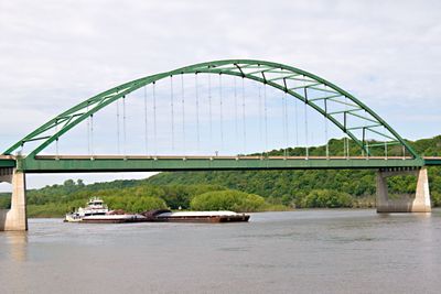
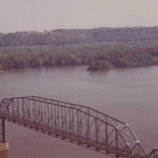
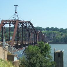
The Dubuque-Wisconsin Bridge is a steel arch bridge spanning the Mississippi River and connecting Iowa with Wisconsin. The structure features four traffic lanes and carries US Highway 61 across the water with a distinctive arched design.

The bridge opened in 1982 and replaced an older crossing to handle increased traffic between the two states. Its construction in the early 1980s involved significant engineering challenges across the river valley.

During construction in 1980, workers discovered a Native American burial site at the Wisconsin bluff, requiring ceremonial sanctification by a Winnebago medicine man.

The bridge carries US Highway 61 with steady traffic throughout the day. Pedestrians and cyclists should use caution or seek alternate routes, as the structure is primarily designed for motor vehicles.

Workers discovered a significant archaeological site during construction in the early 1980s. This finding required special ceremonial recognition before work could continue.

The community of curious travelers

AroundUs brings together thousands of curated places, local tips, and hidden gems, enriched daily by 60,000 contributors worldwide.

Start exploring
Location
Location
Inception
August 21, 1982
Official opening
August 21, 1982
GPS coordinates
42.51556,-90.63556
Latest update
December 12, 2025 08:01
Around this place
National Mississippi River Museum & Aquarium
United States of America

National Mississippi River Museum & Aquarium

3 km
Diamond Jo Casino
United States of America

Diamond Jo Casino

2.9 km
Shot Tower
United States of America

Shot Tower

2.3 km
Lock and Dam No. 11
United States of America

Lock and Dam No. 11

2.8 km
Mathias Ham House
United States of America

Mathias Ham House

2.2 km
Dubuque County Courthouse
United States of America

Dubuque County Courthouse

2.9 km
Eagle Point Bridge
United States of America

Eagle Point Bridge

2.5 km
Eagle Point Park
United States of America

Eagle Point Park

2.9 km
Saint Mary's Catholic Church
United States of America

Saint Mary's Catholic Church

2.7 km
Town Clock
United States of America

Town Clock

3.1 km
United States of America

Grand River Event Center

2.5 km
Dubuque Rail Bridge
United States of America

Dubuque Rail Bridge

2.2 km
Dubuque County Jail
United States of America

Dubuque County Jail

2.9 km
Grand Opera House
United States of America

Grand Opera House

2.9 km
Saint Patrick's Church
United States of America

Saint Patrick's Church

2.9 km
St. Luke's United Methodist Church
United States of America

St. Luke's United Methodist Church

3 km
St. John's Episcopal Church
United States of America

St. John's Episcopal Church

3 km
Upper Main Street Historic District
United States of America

Upper Main Street Historic District

3 km
Jackson Park Historic District
United States of America

Jackson Park Historic District

3 km
Sacred Heart School
United States of America

Sacred Heart School

2.6 km
Dubuque Millworking Historic District
United States of America

Dubuque Millworking Historic District

2.7 km
Interstate Power Company Building
United States of America

Interstate Power Company Building

3 km
Security Building
United States of America

Security Building

3 km
Dubuque City Hall
United States of America

Dubuque City Hall

2.9 km
Dubuque YMCA Building
United States of America

Dubuque YMCA Building

3 km
Hollenfelz House
United States of America

Hollenfelz House

2.8 km
Upper Iowa Street Historic District
United States of America

Upper Iowa Street Historic District

3.1 km
Washington Residential Historic District
United States of America

Washington Residential Historic District

2.7 km
Show the full map
Reviews
Share your experience

No review yet

Discussions
Start a discussion...

No discussion yet

« Dubuque–Wisconsin Bridge - Steel arch bridge in Dubuque, United States » is provided by Around Us (aroundus.com). Images and texts are derived from Wikimedia project under a Creative Commons license. You are allowed to copy, distribute, and modify copies of this page, under the conditions set by the license, as long as this note is clearly visible.

Discover hidden gems everywhere you go!

From secret cafés to breathtaking viewpoints, skip the crowded tourist spots and find places that match your style. Our app makes it easy with voice search, smart filtering, route optimization, and insider tips from travelers worldwide. Download now for the complete mobile experience.

Around Us App Screenshot

A unique approach to discovering new places

Le Figaro

All the places worth exploring

France Info

A tailor-made excursion in just a few clicks

20 Minutes

Around Us
Travel Guide & Maps
Download

Send to your phone

QR Code
1

Open the camera app on your mobile.

2

Point at the QR code with your camera. A notification will appear.

3

Tap the notification to open the link.