Enable Location

We need your location to show you interesting places around you

Discover nearby places

Find interesting locations and hidden gems around you

Precise directions

Get accurate directions and distances to places

Your location is never shared with other users. It's only used when you tap the location button.

Interstate 270

Log in to your account

Start exploring — it's free

Trusted by 62,834 travelers worldwide

Continue with Google
Continue with Apple
or

We will send you a code to connect

By continuing, you accept our Terms and Conditions and our Privacy Policy

Check your inbox

We've sent a pincode in your inbox. Please enter the code below.

Interstate 270

Interstate 270, Major interstate highway in Montgomery and Frederick Counties, United States

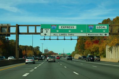
Interstate 270 is a major highway spanning roughly 35 miles from Bethesda to Frederick. The road features separate express and local lanes to manage significant traffic volumes.

The road began as an expressway project in the 1950s and received its current designation in 1973. Upgrades occurred gradually to match the region's expanding development.

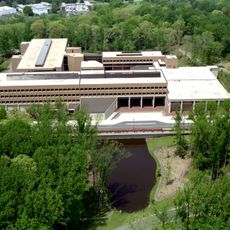
The corridor passes through an area with numerous biotechnology companies and research facilities. This concentration has shaped the region into a center for scientific innovation.

High-occupancy vehicle lanes operate during peak hours between Bethesda and Gaithersburg for carpools and multiple-passenger vehicles. Understanding the lane configuration helps you navigate more efficiently.

The number of lanes changes dramatically, with twelve lanes in Montgomery County reducing to four lanes in Frederick County. This shift reflects the different population pressures and development patterns of the two counties.

The community of curious travelers

AroundUs brings together thousands of curated places, local tips, and hidden gems, enriched daily by 60,000 contributors worldwide.

Start exploring
Location
Inception
1975
GPS coordinates
39.01868,-77.10353
Latest update
December 20, 2025 14:17
Around this place
Washington D.C. Temple
United States of America

Washington D.C. Temple

3.3 km
United States National Library of Medicine
United States of America

United States National Library of Medicine

2.7 km
Uniformed Services University of the Health Sciences
United States of America

Uniformed Services University of the Health Sciences

2.5 km
Columbia Country Club
United States of America

Columbia Country Club

3.1 km
Bethesda Meeting House
United States of America

Bethesda Meeting House

1.1 km
Riley-Bolten House
United States of America

Riley-Bolten House

3.2 km
Bethesda Theatre
United States of America

Bethesda Theatre

3.6 km
Woodend
United States of America

Woodend

3.6 km
Congregation Beth El
United States of America

Congregation Beth El

2.9 km
Kensington Historic District
United States of America

Kensington Historic District

2.5 km
North Bethesda Market
United States of America

North Bethesda Market

2.8 km
Rock Creek Woods Historic District
United States of America

Rock Creek Woods Historic District

3.7 km
Cedar Lane Unitarian Universalist Church
United States of America

Cedar Lane Unitarian Universalist Church

1.4 km
Garrett Park Historic District
United States of America

Garrett Park Historic District

2.1 km
Moreland
United States of America

Moreland

3.5 km
Music Center at Strathmore
United States of America

Music Center at Strathmore

1.4 km
Mansion at Strathmore
United States of America

Mansion at Strathmore

1.4 km
Wyngate Woods Park
United States of America

Wyngate Woods Park

2.5 km
Bethesda Trolley Trail
United States of America

Bethesda Trolley Trail

801 m
Noyes Library For Young Children
United States of America

Noyes Library For Young Children

2.7 km
Davis Library
United States of America

Davis Library

2.2 km
Bradley Hills Park
United States of America

Bradley Hills Park

3.5 km
St. Jane Frances de Chantal, Bethesda
United States of America

St. Jane Frances de Chantal, Bethesda

1.3 km
The Ratner Museum
United States of America

The Ratner Museum

1.5 km
Luxmanor Park
United States of America

Luxmanor Park

3.7 km
Chevy Chase Library
United States of America

Chevy Chase Library

3.8 km
Kensington Park Library
United States of America

Kensington Park Library

2.2 km
Gifford Pinchot Forest Building
United States of America

Gifford Pinchot Forest Building

599 m
Show the full map
« Interstate 270 - Major interstate highway in Montgomery and Frederick Counties, United States » is provided by Around Us (aroundus.com). Images and texts are derived from Wikimedia project under a Creative Commons license. You are allowed to copy, distribute, and modify copies of this page, under the conditions set by the license, as long as this note is clearly visible.

Discover hidden gems everywhere you go!

From secret cafés to breathtaking viewpoints, skip the crowded tourist spots and find places that match your style. Our app makes it easy with voice search, smart filtering, route optimization, and insider tips from travelers worldwide. Download now for the complete mobile experience.

Around Us App Screenshot

A unique approach to discovering new places

Le Figaro

All the places worth exploring

France Info

A tailor-made excursion in just a few clicks

20 Minutes

Around Us
Travel Guide & Maps
Download

Send to your phone

QR Code
1

Open the camera app on your mobile.

2

Point at the QR code with your camera. A notification will appear.

3

Tap the notification to open the link.