Chest opened
+${chestReward.xp} XP
Explorer
NOUVEAU ×${chestReward.collectible.quantity}
tapez pour fermer
Chest locked

Open chests in the app

Around Us is built for your phone — chests unlock when you walk, explore and capture nearby places.

Enable Location

We need your location to show you interesting places around you

Discover nearby places

Find interesting locations and hidden gems around you

Precise directions

Get accurate directions and distances to places

Your location is never shared with other users. It's only used when you tap the location button.

Log in to your account

Start exploring — it's free

Trusted by 72,876 travelers worldwide

Continue with Google
Continue with Apple
or

We will send you a code to connect

By continuing, you accept our Terms and Conditions and our Privacy Policy

Check your inbox

We've sent a pincode in your inbox. Please enter the code below.

Alcona Dam Pond
Discussion Reviews Photo
1.2k Popularity

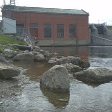
Alcona Dam Pond, reservoir in Alcona County, Michigan, USA

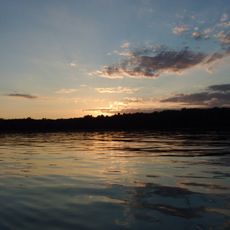
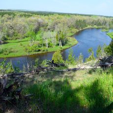
Alcona Dam Pond is a large reservoir in Alcona County, Michigan, created when a dam was built across the Au Sable River to control water flow. The water body covers about 953 acres with depths reaching around 40 feet (12 meters) at its deepest point and is fed by the Au Sable River and smaller streams including Bamfield Creek and Wilbur Creek.

The Alcona Dam was built many decades ago to regulate river flow and prevent flooding in the area. Since then, this reservoir has become a permanent feature of the local landscape and has developed into an important location for both recreation and water management for the region.

The name comes from Alcona County, which surrounds this place. You can see how people use the water for daily life and fun when boats move across the surface and families gather along the shore. This spot shows how a community has adapted its landscape for both work and leisure.

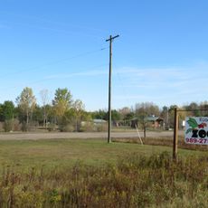
You can reach the shoreline by taking local roads that lead to the water's edge, where facilities are modest. Plan your visit during daytime hours when lighting conditions are best and be aware that weather changes with the seasons throughout the year.

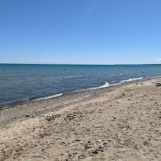
The water shifts in color and appearance depending on the season and time of day, giving the place an ever-changing quality. Summer brings a smooth, reflective surface while winter transforms it into quiet frozen ice, and autumn colors from surrounding trees mirror across the water.

The community of curious travelers

AroundUs brings together thousands of curated places, local tips, and hidden gems, enriched daily by 60,000 contributors worldwide.

Start exploring
Location
GPS coordinates
44.56250,-83.80000
Latest update
February 9, 2026 07:45
Around this place
Lumberman's Monument
United States of America

Lumberman's Monument

19.9 km
Sturgeon Point Light
United States of America

Sturgeon Point Light

44.9 km
Tawas Point State Park
United States of America

Tawas Point State Park

44.3 km
Harrisville State Park
United States of America

Harrisville State Park

41.2 km
Au Sable State Forest
United States of America

Au Sable State Forest

59.3 km
Tawas Point Light
United States of America

Tawas Point Light

44.3 km
Negwegon State Park
United States of America

Negwegon State Park

49.7 km
Tawas Point Camper's Beach
United States of America

Tawas Point Camper's Beach

44.1 km
Alabaster Historic District
United States of America

Alabaster Historic District

45.7 km
Five Channels Dam
United States of America

Five Channels Dam

15.4 km
Cooke Dam
United States of America

Cooke Dam

20.7 km
United States of America

Temple Beth El

62.3 km
Roscommon Zoo
United States of America

Roscommon Zoo

54.6 km
Harrisville State Park Beach
United States of America

Harrisville State Park Beach

41.2 km
Douglas House
United States of America

Douglas House

60.3 km
Oscoda County Courthouse
United States of America

Oscoda County Courthouse

27.8 km
Ogemaw Hills Pathway
United States of America

Ogemaw Hills Pathway

41.3 km
Bingham School
United States of America

Bingham School

62.4 km
Second Arenac County Courthouse
United States of America

Second Arenac County Courthouse

57.5 km
Dinosaur Gardens
United States of America

Dinosaur Gardens

48.4 km
Ogemaw Lanes & Lounge
United States of America

Ogemaw Lanes & Lounge

46.7 km
Thunder Bowl Lanes
United States of America

Thunder Bowl Lanes

60.2 km
Hi-Skore Lanes & Bar
United States of America

Hi-Skore Lanes & Bar

48.6 km
White Pine National
United States of America

White Pine National

31 km
Wurtsmith Air Museum
United States of America

Wurtsmith Air Museum

37 km
Wild Frontier Fun Park
United States of America

Wild Frontier Fun Park

31.3 km
CoopersVille USA
United States of America

CoopersVille USA

48 km
Au Sable National Scenic River
United States of America

Au Sable National Scenic River

16.3 km
Show the full map
Reviews
Share your experience

No review yet

Discussions
Start a discussion...

No discussion yet

« Alcona Dam Pond - reservoir in Alcona County, Michigan, USA » is provided by Around Us (aroundus.com). Images and texts are derived from Wikimedia project under a Creative Commons license. You are allowed to copy, distribute, and modify copies of this page, under the conditions set by the license, as long as this note is clearly visible.

Discover hidden gems everywhere you go!

From secret cafés to breathtaking viewpoints, skip the crowded tourist spots and find places that match your style. Our app makes it easy with voice search, smart filtering, route optimization, and insider tips from travelers worldwide. Download now for the complete mobile experience.

Around Us App Screenshot

A unique approach to discovering new places

Le Figaro

All the places worth exploring

France Info

A tailor-made excursion in just a few clicks

20 Minutes

Around Us
Travel Guide & Maps
Download

Send to your phone

QR Code
1

Open the camera app on your mobile.

2

Point at the QR code with your camera. A notification will appear.

3

Tap the notification to open the link.