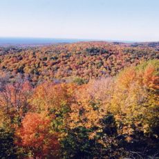
Black River, River and waterfalls system in Ottawa National Forest, Michigan.
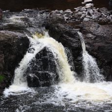
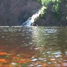
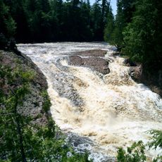
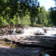
Black River is a waterway in Ottawa National Forest that flows through a deep gorge, creating multiple waterfalls along its course. The falling water reveals slate and sandstone layers that have been shaped over thousands of years.
The river has been used by local communities for centuries before the area became more accessible to travelers in the early 1900s. Infrastructure around the waterfalls grew over time to allow visitors easier access to the waterfall system.
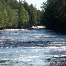
The North Country National Scenic Trail extends along six miles of the river, connecting visitors to the natural heritage of Michigan.
Black River Harbor Road provides access to walking trails, observation points, and picnic areas near the waterfalls. Summer and early fall offer the best visiting conditions when trails are passable and water flow reaches its peak.
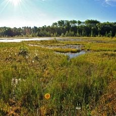
The area is home to salmon populations including coho and Chinook salmon that migrate up from Lake Superior to spawn. This yearly movement makes the lower river section an important gathering place for fish during certain seasons.
Location: Michigan
GPS coordinates: 46.31500,-90.02083
Latest update: December 11, 2025 18:06
Porcupine Mountains
54.4 km
Copper Falls State Park
48.3 kmNorthern Highland-American Legion State Forest
41 kmPowell Marsh Wildlife Area
29.2 km
Superior Falls
40.9 km
Ironwood Theatre
19.2 km
Black Tern Bog State Natural Area
46 km
Great Conglomerate Falls
35.4 km
Manido Falls
43.5 km
Nawadaha Falls
43 km
Ironwood Memorial/Municipal Building
19.2 km
Ironwood Carnegie Library
19.2 km
Gogebic County Courthouse
18.8 km
Solomon S. Curry House
19 km
Annala Round Barn
15.8 km
Rice Creek State Natural Area
26.8 km
Fifield Fire Lookout Tower
53.1 km
Old Iron County Courthouse
19.3 km
Bergland Administrative Site
45.9 km
Mellen City Hall
49.2 km
Marion Park Pavilion
48.2 km
Plummer Mine Headframe
23.2 km
Planter Road – Jackson Creek Bridge
22.4 km
Glidden State Bank
47 km
Lake Gogebic State Park
37.7 km
Lake Gogebic
39.4 km
Main Street – Black River Bridge
17.7 km
Smith Rapids Covered Bridge
46.5 kmVisited this place? Tap the stars to rate it and share your experience / photos with the community! Try now! You can cancel it anytime.
Discover hidden gems everywhere you go!
From secret cafés to breathtaking viewpoints, skip the crowded tourist spots and find places that match your style. Our app makes it easy with voice search, smart filtering, route optimization, and insider tips from travelers worldwide. Download now for the complete mobile experience.
A unique approach to discovering new places❞
— Le Figaro
All the places worth exploring❞
— France Info
A tailor-made excursion in just a few clicks❞
— 20 Minutes