Enable Location

We need your location to show you interesting places around you

Discover nearby places

Find interesting locations and hidden gems around you

Precise directions

Get accurate directions and distances to places

Your location is never shared with other users. It's only used when you tap the location button.

Cormorant Rock

Log in to your account

Start exploring — it's free

Trusted by 62,125 travelers worldwide

Continue with Google
Continue with Apple
or

We will send you a code to connect

By continuing, you accept our Terms and Conditions and our Privacy Policy

Check your inbox

We've sent a pincode in your inbox. Please enter the code below.

Cormorant Rock

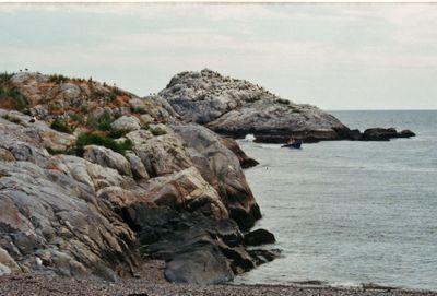
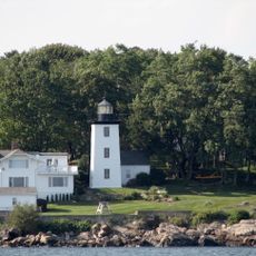
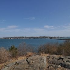
Cormorant Rock, Rocky island near Marblehead Harbor, Massachusetts, US

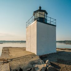
Cormorant Rock is a small rocky outcrop situated near Marblehead Harbor, rising approximately 300 feet from the southeastern shore of Children's Island. The formation creates a noticeable landmark in the coastal waters and serves as an important navigational reference point for vessels traveling through the harbor.

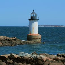
A navigational beacon was established on this rock in 1808 by the Marblehead Marine Society to guide ships through Salem Harbor waters. The beacon became a crucial aid for maritime traffic in this historically active shipping region.

Local maritime organizations continue their long tradition of monitoring and maintaining navigational safety measures around the rock for vessel protection.

Reaching this rock requires a boat or kayak since it sits in open water away from shore. Plan your visit during calm weather and stable water conditions, as currents in this harbor area can shift unpredictably.

The waters surrounding these rocks actually belong to Salem administratively, not Marblehead, despite being closer to Marblehead Harbor. This quirk of local jurisdiction creates an interesting detail in the harbor's geography that catches the attention of those who know the region's boundaries.

The community of curious travelers

AroundUs brings together thousands of curated places, local tips, and hidden gems, enriched daily by 60,000 contributors worldwide.

Start exploring
GPS coordinates
42.50954,-70.81199
Latest update
December 14, 2025 18:14
Around this place
Salem Willows
United States of America

Salem Willows

5.5 km
Pioneer Village
United States of America

Pioneer Village

6 km
Nathaniel Hawthorne Birthplace
United States of America

Nathaniel Hawthorne Birthplace

6.1 km
Fort Sewall
United States of America

Fort Sewall

2.4 km
Abbot Hall
United States of America

Abbot Hall

3.4 km
Marblehead Light
United States of America

Marblehead Light

1.8 km
United States of America

West Beach, Beverly, Massachusetts

5.8 km
Herreshoff Castle
United States of America

Herreshoff Castle

3.1 km
Jeremiah Lee Mansion
United States of America

Jeremiah Lee Mansion

3.3 km
Marblehead Historic District
United States of America

Marblehead Historic District

3.1 km
Bakers Island Light
United States of America

Bakers Island Light

3.7 km
General John Glover House
United States of America

General John Glover House

3 km
United States of America

Juniper Cove

5.3 km
Derby Wharf Light
United States of America

Derby Wharf Light

5.9 km
Hospital Point Range Front Light
United States of America

Hospital Point Range Front Light

5.5 km
Elbridge Gerry House
United States of America

Elbridge Gerry House

3 km
Robert "King" Hooper Mansion
United States of America

Robert "King" Hooper Mansion

4.9 km
Old Town House
United States of America

Old Town House

3.2 km
Simon Bradstreet House
United States of America

Simon Bradstreet House

3 km
Fort Pickering Light
United States of America

Fort Pickering Light

4.9 km
Marblehead Little Theatre
United States of America

Marblehead Little Theatre

3.8 km
Old Meeting House
United States of America

Old Meeting House

2.8 km
Marblehead Colonial Raised House
United States of America

Marblehead Colonial Raised House

3.2 km
Harris Farm
United States of America

Harris Farm

4.7 km
Salem Willows Historic District
United States of America

Salem Willows Historic District

5.3 km
Seaside Park
United States of America

Seaside Park

4.1 km
Captain Robert Haskell House
United States of America

Captain Robert Haskell House

5.8 km
Marblehead Neck Wildlife Sanctuary
United States of America

Marblehead Neck Wildlife Sanctuary

2.9 km
Show the full map
« Cormorant Rock - Rocky island near Marblehead Harbor, Massachusetts, US » is provided by Around Us (aroundus.com). Images and texts are derived from Wikimedia project under a Creative Commons license. You are allowed to copy, distribute, and modify copies of this page, under the conditions set by the license, as long as this note is clearly visible.

Discover hidden gems everywhere you go!

From secret cafés to breathtaking viewpoints, skip the crowded tourist spots and find places that match your style. Our app makes it easy with voice search, smart filtering, route optimization, and insider tips from travelers worldwide. Download now for the complete mobile experience.

Around Us App Screenshot

A unique approach to discovering new places

Le Figaro

All the places worth exploring

France Info

A tailor-made excursion in just a few clicks

20 Minutes

Around Us
Travel Guide & Maps
Download

Send to your phone

QR Code
1

Open the camera app on your mobile.

2

Point at the QR code with your camera. A notification will appear.

3

Tap the notification to open the link.