Enable Location

We need your location to show you interesting places around you

Discover nearby places

Find interesting locations and hidden gems around you

Precise directions

Get accurate directions and distances to places

Your location is never shared with other users. It's only used when you tap the location button.

East Lynn Lake

Log in to your account

Start exploring — it's free

Trusted by 62,533 travelers worldwide

Continue with Google
Continue with Apple
or

We will send you a code to connect

By continuing, you accept our Terms and Conditions and our Privacy Policy

Check your inbox

We've sent a pincode in your inbox. Please enter the code below.

East Lynn Lake

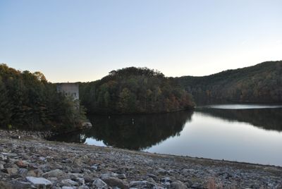
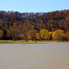
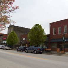
East Lynn Lake, State Wildlife Management Area in Wayne County, West Virginia

East Lynn Lake is a large reservoir in West Virginia that winds through hills and valleys like a meandering river. The water covers several hundred acres with numerous quiet coves, and the surrounding land includes campgrounds, picnic areas, and boat launch facilities.

The lake was built by the U.S. Army Corps of Engineers in the mid-20th century for flood control and officially named in 1971. Its construction significantly altered the region, including the flooding of the town of Stiltner and the relocation of a section of West Virginia Route 37.

The lake takes its name from the nearby town of East Lynn and shapes how locals spend their leisure time. People gather here to fish, boat, and picnic, making it a natural meeting point for outdoor recreation and community connection.

The lake is best visited from late spring through fall, with summer attracting the most visitors. A visitor center nearby provides maps and information, while boat launches, parking, and restroom facilities are available at multiple locations around the reservoir.

The lake is home to 29 native fish species and has gained recognition among anglers for record-breaking catches. Several fishermen have landed fish here that set state records, making it a destination for serious angling enthusiasts.

The community of curious travelers

AroundUs brings together thousands of curated places, local tips, and hidden gems, enriched daily by 60,000 contributors worldwide.

Start exploring
Location
GPS coordinates
38.14500,-82.38390
Latest update
February 7, 2026 11:40
Around this place
Camden Park
United States of America

Camden Park

30.1 km
Fairfield Stadium
United States of America

Fairfield Stadium

29.8 km
Huntington Museum of Art
United States of America

Huntington Museum of Art

28 km
Beech Fork State Park
United States of America

Beech Fork State Park

18.6 km
Chesapeake and Ohio 1308
United States of America

Chesapeake and Ohio 1308

30.1 km
Beech Fork Lake
United States of America

Beech Fork Lake

19 km
Heritage Farm Museum and Village
United States of America

Heritage Farm Museum and Village

26.8 km
Yatesville Lake State Park
United States of America

Yatesville Lake State Park

27.3 km
Old Huntington High School
United States of America

Old Huntington High School

30.3 km
Douglass Junior and Senior High School
United States of America

Douglass Junior and Senior High School

30.3 km
Hermitage of the Holy Cross
United States of America

Hermitage of the Holy Cross

9.1 km
Ritter Park Historic District
United States of America

Ritter Park Historic District

29.2 km
Cabwaylingo State Forest
United States of America

Cabwaylingo State Forest

19.3 km
Pink Bridge
United States of America

Pink Bridge

29.6 km
Memorial Arch
United States of America

Memorial Arch

29.9 km
Ohev Sholom Temple
United States of America

Ohev Sholom Temple

30.1 km
Lincoln National Bank
United States of America

Lincoln National Bank

28.4 km
Fred M. Vinson Birthplace
United States of America

Fred M. Vinson Birthplace

19.4 km
West Virginia Colored Children's Home
United States of America

West Virginia Colored Children's Home

29.4 km
Simms School Building
United States of America

Simms School Building

30.2 km
Mortimer Place Historic District
United States of America

Mortimer Place Historic District

29.8 km
Ricketts House
United States of America

Ricketts House

29.1 km
First United Methodist Church
United States of America

First United Methodist Church

19.7 km
Prichard House
United States of America

Prichard House

29.9 km
Louisa United Methodist Church
United States of America

Louisa United Methodist Church

19.4 km
Captain Freese House
United States of America

Captain Freese House

19.7 km
Louisa Commercial Historic District
United States of America

Louisa Commercial Historic District

19.5 km
Big Sandy Milling Company
United States of America

Big Sandy Milling Company

19.7 km
Show the full map
« East Lynn Lake - State Wildlife Management Area in Wayne County, West Virginia » is provided by Around Us (aroundus.com). Images and texts are derived from Wikimedia project under a Creative Commons license. You are allowed to copy, distribute, and modify copies of this page, under the conditions set by the license, as long as this note is clearly visible.

Discover hidden gems everywhere you go!

From secret cafés to breathtaking viewpoints, skip the crowded tourist spots and find places that match your style. Our app makes it easy with voice search, smart filtering, route optimization, and insider tips from travelers worldwide. Download now for the complete mobile experience.

Around Us App Screenshot

A unique approach to discovering new places

Le Figaro

All the places worth exploring

France Info

A tailor-made excursion in just a few clicks

20 Minutes

Around Us
Travel Guide & Maps
Download

Send to your phone

QR Code
1

Open the camera app on your mobile.

2

Point at the QR code with your camera. A notification will appear.

3

Tap the notification to open the link.